inforesta Sistema diffuso di informazione e educazione ambientale sulle foreste della Sardegna Parco Aymerich Complesso Forestale Barigadu Foresta Demaniale Campidano Foresta Demaniale Limbara Sud Foresta Demaniale Montes Foresta Demaniale Montarbu Foresta Demaniale Monte Pisanu Foresta Demaniale Pantaleo Foresta Demaniale Porto Conte
Transcript
inforestaSistema diffuso di informazione e educazione ambientale sulle foreste della Sardegna
Parco Aymerich
Complesso Forestale Barigadu
Foresta Demaniale Campidano
Foresta Demaniale Limbara Sud
Foresta Demaniale Montes
Foresta Demaniale Montarbu
Foresta Demaniale Monte Pisanu
Foresta Demaniale Pantaleo
Foresta Demaniale Porto Conte
Folder.indd 1 14-07-2008 17:04:52
A spasso nel parco
la conservazione e valorizzazione della biodiversità
Parco Aymerich
8 - parco aymerich.indd 1 14-07-2008 17:17:22
centro servizivisitor center
parcheggioparking
ingresso sentierotrail entrance
sentierotrail
area sostapicnic area
punto panoramicovista point
punto di interessepoint of interest
sorgentespring water
Dati sul percorso Trail information
Trail: Circular, 2.330 kmSlope: Max 30%Difficulty: EasyDuration: 75 minutes at a leisurely paceRest area: Benches in the locality of Funtana LadisClothing: Comfortable sportswear
Percorso: anulare, km 2,330Pendenza: max 30%Difficoltà: bassaDurata: 75' a passo lentoArea di sosta: attrezzata con panche in località Funtana LadusAbbigliamento: sportivo e comodo
8 - parco aymerich.indd 2 14-07-2008 17:17:24
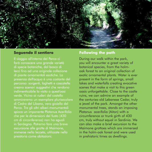
Il viaggio all'interno del Parco ci farà conoscere una grande varietà di specie botaniche, dal bosco di lecci fino ad una originale collezione di piante ornamentali esotiche. La presenza dell'acqua è una costante del percorso: sorgenti, laghetti e cascatelle creano scenari suggestivi che rendono indimenticabile la visita a quest'oasi verde. Vicino ai ruderi del castello ammireremo un esemplare plurisecolare di Cedro del Libano, vero gioiello del Parco. Tra gli altri alberi monumentali spicca un imponente Platanus Acerifolia che per le dimensioni del fusto (430 cm di circonferenza) non ha eguali in Sardegna. Potremo fare una breve escursione alle grotte di Maimone, immerse nella lecceta, utilizzate nella preistoria come abitazioni.
During our walk within the park, you will encounter a great variety of botanical species, from the holm-oak forest to an original collection of exotic ornamental plants. Water is ever present in the form of springs, small lakes and waterfalls creating evocative scenes that make a visit to this green oasis unforgettable. Close to the castle ruins, we can admire an example of the centuries-old Lebanese Cedar, truly a jewel of the park. Amongst the other monumental trees, stands an imposing Platanus acerifolia (Aiton) with a circumference or trunk girth of 430 cm, truly without equal in Sardinia. We can also make a brief excursion to the Maimone grottoes which are immersed in the holm-oak forest and were used in prehistoric times as dwellings.
Following the pathSeguendo il sentiero
8 - parco aymerich.indd 3 14-07-2008 17:17:25
Il Parco Aymerich, dal nome della famiglia cui appartenne fino al 1990, si estende per circa 22 ettari su una dolce collina digradante dai 600 ai 500 metri sul livello del mare. La sua superficie è tradizionalmente suddivisa in due zone: l'area storica e quella ricreativa. La prima è contraddistinta dai ruderi di un castello medievale in cui soggiornò la giudicessa Eleonora d'Arborea nei suoi periodi di riposo. La zona ricreativa riveste invece principalmente un interesse ambientale e paesaggistico. Le specie botaniche non indigene, grazie anche al favorevole clima temperato, si inseriscono con grande naturalezza nella vegetazione spontanea esistente, costitui-ta in prevalenza da boschi di leccio e roverella.
Alla scoperta della Foresta
8 - parco aymerich.indd 4 14-07-2008 17:17:29
Features of the Forest
Aymerich Park, so named after the Aymerich Family, who owned it until 1990, extends for about 22 hectares on a gentle hill slope from 600 m to 500 m above sea level. Traditionally, the park has been divided into two areas, one historical and the other recreational. The historical area is characterised by the medieval castle ruins, the retreat of the Judge Eleonora d’Arborea during her periods of rest. The main attraction of the recreational area is represented by its environment and landscape. Partly due to a favourable climate, the non-indigenous botanical species have naturally blended with the existing spontaneous vegetation consisting prevalently of holm and downy oak thickets.
8 - parco aymerich.indd 5 14-07-2008 17:17:30
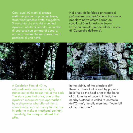
Con i suoi 40 metri di altezza svetta nel parco un pino calabrese, straordinariamente dritto e regolare. Si racconta che uno dei marchesi Aymerich rifiutò di cederlo, in cambio di una cospicua somma di denaro, ad un armatore che ne voleva fare il pennone di una nave.
Nei pressi della falesia principale si può notare una cavità che la tradizione popolare narra essere l'orma del cavallo di Sant'Ignazio da Laconi. La vicina cascata prende infatti il nome di "Cascatella dell'orma".
A Calabrian Pine of 40 m, extraordinarily neat and straight, stands out as the tallest tree in the park The story goes that once, one of the Aymerich marquises was approached by a shipowner who offered him a considerable sum of money for the tree in order to make a masthead pennant. Thankfully, the marquis refused this offer.
In the vicinity of the principle cliff there is a hole that is said by popular belief to be the hoof print of the horse of St. Ignatius of Laconi. In fact, the nearby waterfall is called “Cascatella dell’Orma”, literally meaning, “waterfall of the hoof print”.
8 - parco aymerich.indd 6 14-07-2008 17:17:34
Come arrivare
Il Parco è aperto tutto l’anno, tutti i giorni della settimana. L’orario d’apertura è variabile: da aprile a settembre dalle 8.00 a.m. alle 20.00; da ottobre a marzo dalle 8.00 a.m. alle 16.00.
The park is open everyday all year round.Opening hours: April - September:from 8am till 8pmOctober - March:from 8am till 4pm
How to get there
8 - parco aymerich.indd 7 14-07-2008 17:17:36
Regione Autonoma della SardegnaEnte Foreste della Sardegna
Sistema diffuso di informazione e educazione ambientale sulle foreste della Sardegnawww.sardegnaforeste.it
8 - parco aymerich.indd 8 14-07-2008 17:17:37
Complesso Forestale Barigadu
paesaggi naturali e culturalitra i segni del passato
Lungo la via dei carbonai
5 - foresta barigadu.indd 1 14-07-2008 17:12:45
Dati sul percorso
Percorso: lineare, km 2 Pendenza: pianeggianteDifficoltà: molto bassaDurata: 80' a passo lentoArea di sosta: attrezzata con tavolie panche in località AssaiAbbigliamento: sportivo e comodo
Trail: Straight, 2 kmTerrain: FlatDifficulty: very easyDuration: 80 minutes at a leisurely paceRest area: an area with picnic tables and benches located in AssaiClothing: Comfortable sportswear
Trail information
centro servizivisitor center
parcheggioparking
ingresso sentierotrail entrance
sentierotrail
area sostapicnic area
punto panoramicovista point
punto di interessepoint of interest
sorgentespring water
5 - foresta barigadu.indd 2 14-07-2008 17:12:47
Seguendo il sentiero Following the path
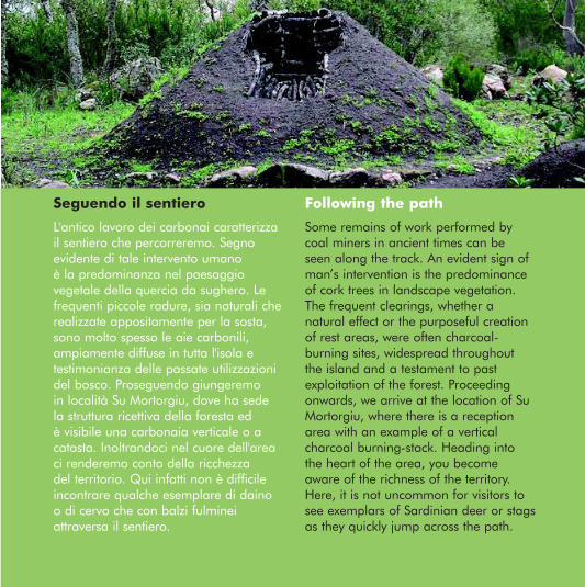
Some remains of work performed by coal miners in ancient times can be seen along the track. An evident sign of man’s intervention is the predominance of cork trees in landscape vegetation. The frequent clearings, whether a natural effect or the purposeful creation of rest areas, were often charcoal-burning sites, widespread throughout the island and a testament to past exploitation of the forest. Proceeding onwards, we arrive at the location of Su Mortorgiu, where there is a reception area with an example of a vertical charcoal burning-stack. Heading into the heart of the area, you become aware of the richness of the territory. Here, it is not uncommon for visitors to see exemplars of Sardinian deer or stags as they quickly jump across the path.
L'antico lavoro dei carbonai caratterizza il sentiero che percorreremo. Segno evidente di tale intervento umano è la predominanza nel paesaggio vegetale della quercia da sughero. Le frequenti piccole radure, sia naturali che realizzate appositamente per la sosta, sono molto spesso le aie carbonili, ampiamente diffuse in tutta l'isola e testimonianza delle passate utilizzazioni del bosco. Proseguendo giungeremo in località Su Mortorgiu, dove ha sede la struttura ricettiva della foresta ed è visibile una carbonaia verticale o a catasta. Inoltrandoci nel cuore dell'area ci renderemo conto della ricchezza del territorio. Qui infatti non è difficile incontrare qualche esemplare di daino o di cervo che con balzi fulminei attraversa il sentiero.
5 - foresta barigadu.indd 3 14-07-2008 17:12:47
Alla scoperta della Foresta
Nel complesso forestale nasce nel 1983 l'Oasi di Assai, zona di protezione faunistica permanente. Gli animali che la popolano rivestono infatti grande interesse scientifico: oltre al daino e al cervo sardo, qui, tra le altre specie, vivono in tutta tranquillità numerosi cinghiali, gatti selvatici e martore. Tra i rami dei lecci e delle querce nidificano alcuni endemismi sardo-corsi, come lo sparviere, il picchio rosso maggiore, la cincia mora, lo zigolo nero. Sono presenti anche il raro ed elusivo passero solitario, la ghiandaia, il corvo imperiale, la pernice sarda, il colombaccio. Recentemente, dopo tanti anni di assenza, è tornata a nidificare nell'area l'aquila reale: senza dubbio un segnale positivo che ci fa capire che la situazione faunistico-ambientale sta evolvendo verso un equilibrio sempre più stabile.
5 - foresta barigadu.indd 4 14-07-2008 17:12:50
Features of the Forest
In 1983, the forest compound gave birth to the Oasis of Assai, a permanent protec-ted wildlife area for wildlife. The animals are of great scientific interest: Sardinian deer and stags live in complete harmony with the wild boar, wild cats and martens. Between the branches of the holm oak and cork trees nest some Sardo-corsican species like the sparrowhawk, the great spotted woodpecker, the coal tit and the cirl bunting. Also present are: the rare and elusive blue rock thrush, the Eurasian jay, the common raven, Barbary partridge and woodpigeon. Recently, after years of absence, the golden eagle has returned to nest in the area, without doubt a positive sign that the territorial wildlife is returning because of the ever more stable environment.
5 - foresta barigadu.indd 5 14-07-2008 17:12:51
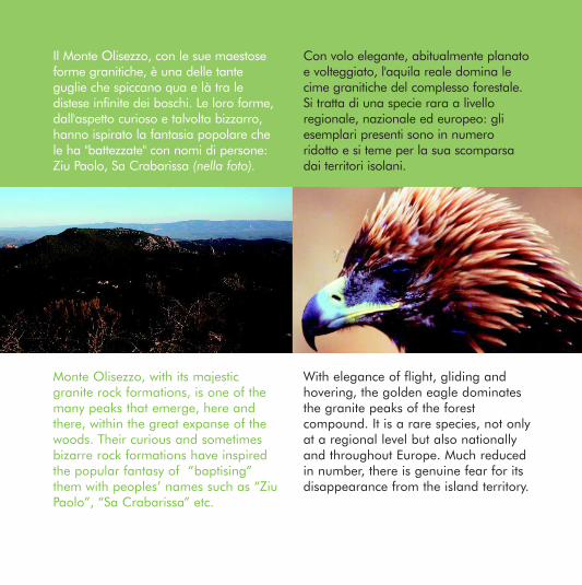
Il Monte Olisezzo, con le sue maestose forme granitiche, è una delle tante guglie che spiccano qua e là tra le distese infinite dei boschi. Le loro forme, dall'aspetto curioso e talvolta bizzarro, hanno ispirato la fantasia popolare che le ha "battezzate" con nomi di persone: Ziu Paolo, Sa Crabarissa (nella foto).
Con volo elegante, abitualmente planato e volteggiato, l'aquila reale domina le cime granitiche del complesso forestale. Si tratta di una specie rara a livello regionale, nazionale ed europeo: gli esemplari presenti sono in numero ridotto e si teme per la sua scomparsa dai territori isolani.
Monte Olisezzo, with its majestic granite rock formations, is one of the many peaks that emerge, here and there, within the great expanse of the woods. Their curious and sometimes bizarre rock formations have inspired the popular fantasy of “baptising” them with peoples’ names such as “Ziu Paolo”, “Sa Crabarissa” etc.
With elegance of flight, gliding and hovering, the golden eagle dominates the granite peaks of the forest compound. It is a rare species, not only at a regional level but also nationally and throughout Europe. Much reduced in number, there is genuine fear for its disappearance from the island territory.
5 - foresta barigadu.indd 6 14-07-2008 17:12:54
Come arrivare How to get there
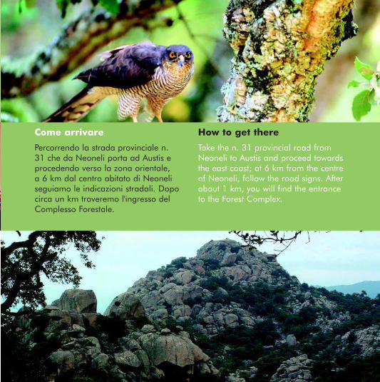
Take the n. 31 provincial road from Neoneli to Austis and proceed towards the east coast; at 6 km from the centre of Neoneli, follow the road signs. After about 1 km, you will find the entrance to the Forest Complex.
Percorrendo la strada provinciale n. 31 che da Neoneli porta ad Austis e procedendo verso la zona orientale, a 6 km dal centro abitato di Neoneli seguiamo le indicazioni stradali. Dopo circa un km troveremo l'ingresso del Complesso Forestale.
5 - foresta barigadu.indd 7 14-07-2008 17:12:56
Regione Autonoma della SardegnaEnte Foreste della Sardegna
Sistema diffuso di informazione e educazione ambientale sulle foreste della Sardegnawww.sardegnaforeste.it
5 - foresta barigadu.indd 8 14-07-2008 17:12:57
I paesaggi del fuoco
Paesaggi naturali e culturali I rischi per l´ambiente forestaleInterventi a favore della foresta
Foresta Demaniale Campidano
9 - foresta campidano.indd 1 14-07-2008 17:07:49
Dati sul percorso
Percorso: km 4Pendenza: dolceDifficoltà: molto facileDurata: 2 ore compreso il rientroArea di sosta: all´inizio del percorsoAbbigliamento: comodo, sportivo, scorta d´acqua
Trail information
Trail: 4 kmSlope: gentleDifficulty: Very easyDuration: 120' including the return walkRest area: At the start of the trailClothing: Comfortable sportswear, drinkable water
centro servizivisitor center
parcheggioparking
ingresso sentierotrail entrance
sentierotrail
area sostapicnic area
punto panoramicovista point
punto di interessepoint of interest
sorgentespring water
cungiaus
bi 'e sinnia
9 - foresta campidano.indd 2 14-07-2008 17:07:51
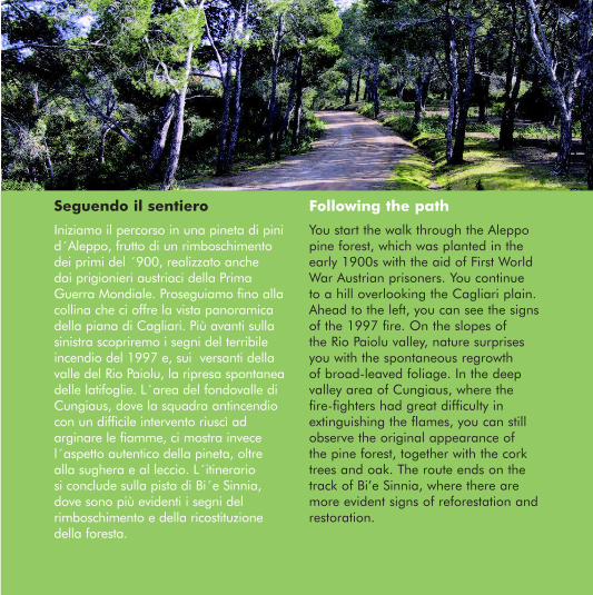
Iniziamo il percorso in una pineta di pini d´Aleppo, frutto di un rimboschimento dei primi del ´900, realizzato anche dai prigionieri austriaci della Prima Guerra Mondiale. Proseguiamo fino alla collina che ci offre la vista panoramica della piana di Cagliari. Più avanti sulla sinistra scopriremo i segni del terribile incendio del 1997 e, sui versanti della valle del Rio Paiolu, la ripresa spontanea delle latifoglie. L´area del fondovalle di Cungiaus, dove la squadra antincendio con un difficile intervento riuscì ad arginare le fiamme, ci mostra invece l´aspetto autentico della pineta, oltre alla sughera e al leccio. L´itinerario si conclude sulla pista di Bi´e Sinnia, dove sono più evidenti i segni del rimboschimento e della ricostituzione della foresta.
You start the walk through the Aleppo pine forest, which was planted in the early 1900s with the aid of First World War Austrian prisoners. You continue to a hill overlooking the Cagliari plain. Ahead to the left, you can see the signs of the 1997 fire. On the slopes of the Rio Paiolu valley, nature surprises you with the spontaneous regrowth of broad-leaved foliage. In the deep valley area of Cungiaus, where the fire-fighters had great difficulty in extinguishing the flames, you can still observe the original appearance of the pine forest, together with the cork trees and oak. The route ends on the track of Bi’e Sinnia, where there are more evident signs of reforestation and restoration.
Following the pathSeguendo il sentiero
9 - foresta campidano.indd 3 14-07-2008 17:07:52
Alla scoperta della Foresta
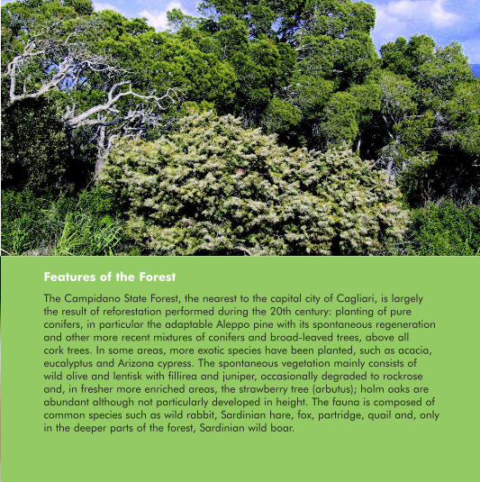
La Foresta Demaniale Campidano, la più vicina al capoluogo, è in gran parte originata dai rimboschimenti eseguiti in tutto il secolo scorso. Si tratta di impianti puri di conifere, in particolare di pino d´Aleppo, che si è ben adattato e che si rinnova spontaneamente, e di altri più recenti misti di conifere e latifoglie, soprattutto sughera. In alcune aree sono state inserite specie esotiche, come acacie, eucalipti e cipressi dell´Arizona. Le formazioni spontanee sono macchie a olivastro e lentisco con fillirea e ginepri, talvolta degradate a cisteti, e nelle aree più fresche arricchite dal corbezzolo; i lecci sono frequenti anche se non particolarmente sviluppati in altezza. La fauna comprende specie piuttosto comuni come il coniglio selvatico, la lepre sarda, la pernice, la quaglia, la volpe, e, solo dove la foresta è più fitta, il cinghiale sardo
9 - foresta campidano.indd 4 14-07-2008 17:09:28
The Campidano State Forest, the nearest to the capital city of Cagliari, is largely the result of reforestation performed during the 20th century: planting of pure conifers, in particular the adaptable Aleppo pine with its spontaneous regeneration and other more recent mixtures of conifers and broad-leaved trees, above all cork trees. In some areas, more exotic species have been planted, such as acacia, eucalyptus and Arizona cypress. The spontaneous vegetation mainly consists of wild olive and lentisk with fillirea and juniper, occasionally degraded to rockrose and, in fresher more enriched areas, the strawberry tree (arbutus); holm oaks are abundant although not particularly developed in height. The fauna is composed of common species such as wild rabbit, Sardinian hare, fox, partridge, quail and, only in the deeper parts of the forest, Sardinian wild boar.
Features of the Forest
9 - foresta campidano.indd 5 14-07-2008 17:07:54
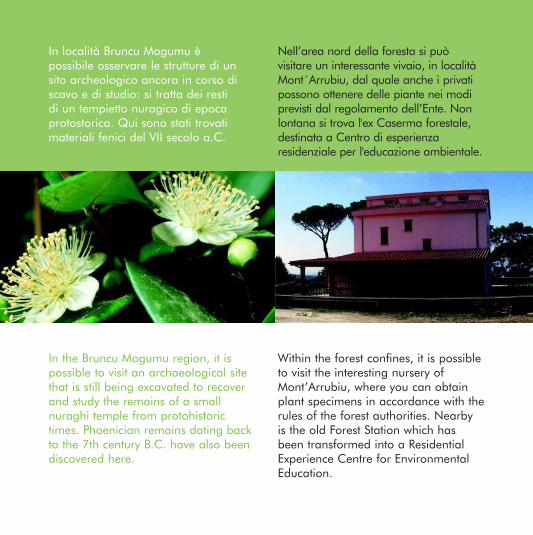
Nell’area nord della foresta si può visitare un interessante vivaio, in località Mont´Arrubiu, dal quale anche i privati possono ottenere delle piante nei modi previsti dal regolamento dell’Ente. Non lontana si trova l'ex Caserma forestale, destinata a Centro di esperienza residenziale per l'educazione ambientale.
In località Bruncu Mogumu è possibile osservare le strutture di un sito archeologico ancora in corso di scavo e di studio: si tratta dei resti di un tempietto nuragico di epoca protostorica. Qui sono stati trovati materiali fenici del VII secolo a.C.
In the Bruncu Mogumu region, it is possible to visit an archaeological site that is still being excavated to recover and study the remains of a small nuraghi temple from protohistoric times. Phoenician remains dating back to the 7th century B.C. have also been discovered here.
Within the forest confines, it is possible to visit the interesting nursery of Mont’Arrubiu, where you can obtain plant specimens in accordance with the rules of the forest authorities. Nearby is the old Forest Station which has been transformed into a Residential Experience Centre for Environmental Education.
9 - foresta campidano.indd 6 14-07-2008 17:08:11
Come arrivare How to get there
The forest can be reached from Sinnai or Soleminis.For further information, please contact: Forest Headquarters in Sa Pira, tel. 070 767596Mont’Arrubiu Nursery, tel. 070 749523Residential Experience Centre for Environmental Education, tel. 070 748019
La foresta si raggiunge da Sinnai e da Soleminis. Per informazioni: Centro di Cantiere Sa Pira tel. 070 767596; Vivaio Mont´Arrubiu, tel. 070 749523; Centro Esperienza Educazione Ambientale, tel. 070 748019.
9 - foresta campidano.indd 7 14-07-2008 17:08:18
Regione Autonoma della SardegnaEnte Foreste della Sardegna
Sistema diffuso di informazione e educazione ambientale sulle foreste della Sardegnawww.sardegnaforeste.it
9 - foresta campidano.indd 8 14-07-2008 17:08:19
Allo stazzo di Tiu Daniele:
dall’utilizzo delle risorse, alla conservazione della biodiversità del paesaggio
Percorso: anulare, km 1,330Pendenza: bassa (500 - 580 m slm)Difficoltà: bassaDurata: 80' a passo lentoArea di sosta: attrezzata con tavoli e panche in località Vivaio
Circular walk: 1.330 kmSlope: gentle (500-580 metres above sea level)Difficulty: EasyDuration: 80 minutes at a leisurely paceRest area: in an area of the Plant Nursery with picnic tables and benches Clothing: Comfortable sportswear
Partiamo dal vivaio, dove un orto botanico raccoglie specie utilizzate in passato nelle opere di rimboschimento e un frutteto dove meli, peri, ciliegi, susini tipici sono l'espressione della biodiversità in Sardegna. Oltre il giardino il sentiero sale gradualmente, offrendoci la veduta di una grande varietà di paesaggi: la Piana di Chilivani e Ozieri, il Lago del Coghinas, il Monte Acuto e sullo sfondo i monti di Alà, Su Filigosu e il Monte Lerno, in spettacolare contrasto con i maestosi graniti del Limbara alle nostre spalle. Proseguiamo lungo una foresta dove la macchia mediterranea si alterna a tratti di lecceta. Tra la rigogliosa vegetazione dominata dal corbezzolo, si apre un sentiero che ci porta verso un vecchio stazzo, detto di "Tiu Daniele".
You start from the nursery where a botanical garden gathers a variety of species deriving from past reforestation efforts and an orchard with apple, pear, plum and cherry trees typically expresses the biodiversity of Sardinia. Beyond the garden, the path gradually slopes upwards, offering splendid views of the Plains of Chilivani and Ozieri, Lake Coghinas, Mount Acuto and in the background, the Alà hills, Su Filigosu and Mount Lerno, in spectacular contrast to the imposing granite rocks of Mount Limbara behind. The trail leads into a forest where the Mediterranean maquis alternates with Holm oak (Quercus ilex) foliage. After winding through the lush vegetation dominated by arbutus-berry, a path opens out towards the old outpost known as “Tiu Daniele”.
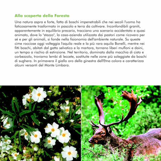
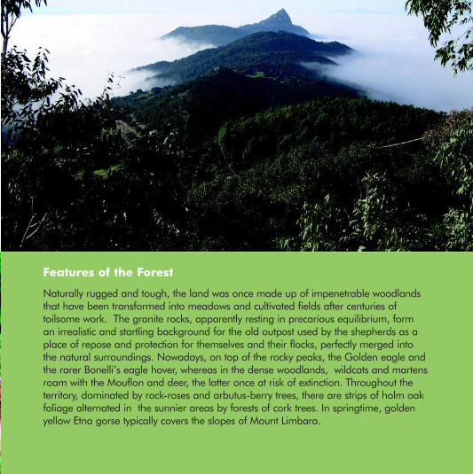
Una natura aspra e forte, fatta di boschi impenetrabili che nei secoli l'uomo ha faticosamente trasformato in pascolo e terra da coltivare. Inconfondibili graniti, apparentemente in equilibrio precario, tracciano uno scenario accidentato e quasi animato, dove lo "stazzo", la casa-azienda utilizzata dai pastori come ricovero per sé e per gli animali, si fonde nella fisionomia dell'ambiente naturale. Su queste cime rocciose oggi volteggia l'aquila reale e la più rara aquila Bonelli, mentre nei fitti boschi, abitati dal gatto selvatico e la martora, tornano liberi mufloni e daini, un tempo a rischio di estinzione. Nel territorio, dominato dalla macchia di cisto e corbezzolo, troviamo lembi di leccete, sostituite nelle zone più soleggiate da boschi di sughera. In primavera il giallo oro della ginestra dell'Etna colora e caratterizza alcuni versanti del Monte Limbara.
Naturally rugged and tough, the land was once made up of impenetrable woodlands that have been transformed into meadows and cultivated fields after centuries of toilsome work. The granite rocks, apparently resting in precarious equilibrium, form an irrealistic and startling background for the old outpost used by the shepherds as a place of repose and protection for themselves and their flocks, perfectly merged into the natural surroundings. Nowadays, on top of the rocky peaks, the Golden eagle and the rarer Bonelli’s eagle hover, whereas in the dense woodlands, wildcats and martens roam with the Mouflon and deer, the latter once at risk of extinction. Throughout the territory, dominated by rock-roses and arbutus-berry trees, there are strips of holm oak foliage alternated in the sunnier areas by forests of cork trees. In springtime, golden yellow Etna gorse typically covers the slopes of Mount Limbara.
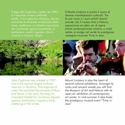
Il lago del Coghinas, creato nel 1927, è il secondo invaso artificialesardo. Il suo specchio d'acqua, che ha arricchito la diversità ambientale della zona, costituisce un habitat importante per numerose specie acquatiche, in particolare uccelli migratori che in inverno vi trovano rifugio.
Il Monte Limbara è anche il cuore di diverse manifestazioni culturali. Tra le sue rocce e i suoi antichi boschi prende vita il museo Arte e Natura, esposizione en plein air di opere d'arte contemporanea mentre, a metà estate, si svolge nel verde la prestigiosa rassegna musicale Time in Jazz.
Lake Coghinas was created in 1927 and is the second largest artificial reservoir in Sardinia. This expanse of water has enriched the diversity of flora and fauna in the area, forming an important habitat for numerous aquatic species, particularly migratory birds sheltering in the winter.
Mount Limbara is also the heart of several cultural exhibitions. Amongst its rocks and ancient woods you will find the Museum of Art and Nature with its open-air exhibition of contemporary art works. In mid-summer it also hosts the prestigious musical event “Time in Jazz”.
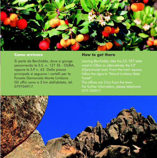
Si parte da Berchidda, dove si giunge percorrendo la S.S. n. 127 SS - OLBIA, oppure la S.P n. 62. Dalla piazza principale si seguono i cartelli per la Foresta Demaniale Monte Limbara. Gli uffici sono a 3 km dall'abitato, tel. 079704917.
Leaving Berchidda, take the S.S. 597 state road to Olbia or, alternatively, the S.P. 62provincial road. From the main square, follow the signs to “Mount Limbara State Forest”.The offices are 3 km from the town.For further information, please telephone 079-704917
Un punto di vista privilegiatosul Supramonte e il Gennargentupaesaggi naturali e culturali tra i segni del passato
Foresta Demaniale Montes
4 - foresta montes.indd 1 14-07-2008 17:16:30
centro servizivisitor center
parcheggioparking
ingresso sentierotrail entrance
sentierotrail
area sostapicnic area
punto panoramicovista point
punto di interessepoint of interest
sorgentespring water
Dati sul percorso
Percorso: km 4,8Pendenza: media (1085 - 1316 m slm)Difficoltà: bassaDurata: 80' a passo lentoArea di sosta: attrezzata con tavoli e panche in località Funtana Bona e presso la caserma forestale
Trail information
Trail: 4.8 kmSlope: Medium, 1085 – 1316 metres above sea levelDifficulty: easyDuration: 80 minutes at a leisurely paceRest area: picnic tables and benches located in the area of Funtana Bona near the forest station
4 - foresta montes.indd 2 14-07-2008 17:16:32
Si parte dalla Caserma Forestale “Ilodei Malu”, percorrendo la strada forestale immersa nel bosco, che costituisce la principale via d'accesso al Supramonte di Orgosolo.Si giunge alla sorgente di Funtana Bona, da cui ha origine il fiume Cedrino, alla base del torrione calcareo del Monte Fumai. Da qui uno stretto sentiero sale sino alla base della falesia attraverso zone cespugliose ricche di specie endemiche e rocce dalle forme talvolta strane e suggestive.
Leaving the “Ilodei Malu” forest station, you take the forest road that forms the main entry point to the Supramonte of Orgosolo. The road leads to the springs of Funtana Bona where, at the base of the large limestone rock towers of Monte Fumai, the Cedrino river has its source.From here, a narrow upward path leads to the base of the cliff, through bushy areas of endemic plant species and im-pressive and occasionally strange rock formations.
Following the pathSeguendo il sentiero
4 - foresta montes.indd 3 14-07-2008 17:16:32
Il paesaggio è quanto mai vario e suggestivo, tra falesie, dirupi e grotte tipiche del calcare cui si contrappongono le forme più dolci degli scisti paleozoici.La vegetazione è altrettanto ricca, con leccete plurisecolari, garighe abitate da branchi di mufloni, campi di fiori selvatici tra i quali spicca la rosa peonia. Particolarmente interessante dal punto di vista naturalistico è Monte Novo San Giovanni, con le sue guglie alte fino a settanta metri. Tutto ciò rende la Foresta di Montes un ambiente unico nel bacino del Mediterraneo.
Alla scoperta della Foresta
4 - foresta montes.indd 4 14-07-2008 17:16:36
The landscape varies between cliffs, ravines and typical limestone grottoes in contrast with the softer forms of the Palaeozoic schist. The vegetation is rich with centuries-old holm oaks, soft-leaved scrublands inhabited by herds of mouflon and fields of wild flowers amongst which the peony rose grows. Particularly interesting from a naturalistic point of view is Mount Nuovo San Giovanni with crests of up to seventy metres high. All this makes the Montes Forest a unique environment within the Mediterranean basin.
Feautures of the Forest
4 - foresta montes.indd 5 14-07-2008 17:16:37
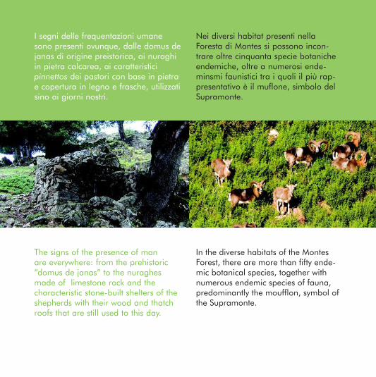
I segni delle frequentazioni umane sono presenti ovunque, dalle domus de janas di origine preistorica, ai nuraghi in pietra calcarea, ai caratteristici pinnettos dei pastori con base in pietra e copertura in legno e frasche, utilizzati sino ai giorni nostri.
Nei diversi habitat presenti nella Foresta di Montes si possono incon-trare oltre cinquanta specie botaniche endemiche, oltre a numerosi ende-minsmi faunistici tra i quali il più rap-presentativo è il muflone, simbolo del Supramonte.
The signs of the presence of man are everywhere: from the prehistoric “domus de janas” to the nuraghes made of limestone rock and the characteristic stone-built shelters of the shepherds with their wood and thatch roofs that are still used to this day.
In the diverse habitats of the Montes Forest, there are more than fifty ende-mic botanical species, together with numerous endemic species of fauna, predominantly the moufflon, symbol of the Supramonte.
4 - foresta montes.indd 6 14-07-2008 17:16:39
Come arrivare How to get there
The forest can easily be reached from Orgosolo (Nuoro) by following the n. 48 provincial road for a distance of about 15 km.For further information, please telephone 0784-201521
La Foresta è facilmente raggiungibile da Orgosolo (NU) percorrendo la strada provinciale 48. La distanza dal paese è di circa 15 chilometri. Per informazioni: tel. 0784.201521
4 - foresta montes.indd 7 14-07-2008 17:16:41
Regione Autonoma della SardegnaEnte Foreste della Sardegna
Sistema diffuso di informazione e educazione ambientale sulle foreste della Sardegnawww.sardegnaforeste.it
4 - foresta montes.indd 8 14-07-2008 17:16:41
Rio Ermolinus,il ruscello nel boscopaesaggi naturali e culturali tra i segni del passato
Foresta Demaniale Montarbu
6 - foresta montarbu.indd 1 14-07-2008 17:19:26
Dati sul percorso
Percorso: anulare, km 1,6; i primi 460 m. fruibili da portatori di handicap Pendenza: pianeggianteDifficoltà: molto bassaDurata: 90' a passo lentoArea di sosta: attrezzata con tavoli e panche nel centro servizi presso la caserma
Distance: Circular, 1.6 km with access for the disabled for the first 460 mTerrain: FlatDifficulty: very easyDuration: 90 min at a leisurely paceRest area: Equipped with tables and benches in the service centre near the forest station
Trail information
centro servizivisitor center
parcheggioparking
ingresso sentierotrail entrance
sentierotrail
area sostapicnic area
punto panoramicovista point
punto di interessepoint of interest
sorgentespring water
6 - foresta montarbu.indd 2 14-07-2008 17:19:28
Il sentiero è vivacizzato dal Rio Ermolinus, che crea nel cuore della foresta un armonico insieme di vaschette di travertino (piscinas). Affacciandoci dai ponticelli in legno scorgeremo, tra rocce e piante acquatiche, la trota sarda. Lungo il percorso le carbonaie (fogaiasa), sono il segno dal lavoro dell'uomo, insieme ai vecchi canali (Is corasa) che portavano l'acqua agli orti, e ai terrazzi coltivati. La flora è costituita da agrifoglio, tasso, carpino nero, frassino, ontano, leccio e cedro. Molto bella è la campagna in primavera, con le splendide fioriture, e in autunno, quando le sfumature di verde, giallo, rosso e marrone si confondono tra loro. Nel sentiero incontreremo "i due sposini", lecci monumentali disposti sulle sponde opposte del torrente.
The path along the Rio Ermolinus, which flows through the very heart of the forest, is enlivened by a series of travertine pools (piscinas). By stopping on the enchanting small wooden bridges, we can spot the Sardinian trout between the rocks and aquatic plants. Along the way, coalpi-les (forgaiasa), mark the work of man, together with the old irrigation channels (Is corasa) that once supplied water to the gardens and cultivated terraces. The flora consists of holly, black hornbeams, yew, ash, alder, oak and cedar. The countrysi-de in filled with beauty, from the blosso-ming colours of spring to the rich array of green, yellow, red and golden brown foliage in autumn. Along the path, we will encounter “I due sposini” (“the newly weds”), two monumental oaks standing on the opposite banks of the stream.
Seguendo il sentiero Following the path
6 - foresta montarbu.indd 3 14-07-2008 17:19:29
Alla scoperta della Foresta
Importante meta turistica, la foresta è attrezzata con accoglienti infrastrutture ricetti-ve e comode piste che la percorrono in tutta la sua estensione. L’area è ricca di siti di valore geologico e geomorfologico di rilevante interesse scientifico e ambientale. Il paesaggio dei Tonneri è caratterizzato da elevati tacchi calcarei, tra cui svetta la Punta Margiani Pubusa con i suoi 1324 m., da spettacolari fenomeni di erosione e carsismo che offre all’osservatore uno straordinario patrimonio di valori costituito da grotte, polje, doline, paleovalli, gole, città di rocce, campi carreggiati, ecc. che ne fanno un luogo unico per il turismo naturalistico e il geoturismo. Dal 1980 l’in-tera superficie della foresta è diventata oasi di protezione faunistica. Tra le specie animali presenti ricordiamo il Cervo Sardo e il Muflone, facilmente osservabili, diventati simbolo del territorio. La foresta, particolarmente ricca d’acqua, è lambita dal Flumendosa.
6 - foresta montarbu.indd 4 14-07-2008 17:19:33
The forest is a major tourist attraction with its delightful series of capillary trails and receptive infrastructures. The territory is rich with geological and geomorphological sites of considerable scientific and environmental interest. The Tonneri landscape is characteristically scattered with tall heel-shaped limestone mounds (tacchi) among which the Punta Margiani Pubusa peaks with its 1324 m, a spectacular phenomenon of erosion that offers the observer an extraordinary and valuable patrimony of grottoes, polje, dolines, paleovalleys, gorges, rock clusters and old wagon trails etc., making this a unique place for naturalistic and geological tourism. Since 1980, the entire forest has become an oasis of wildlife preservation. Amongst the animal species, the Sardinian stag and mouflon are a common sight and have become symbols of the area. The forested area, lapped by the Flumendosa, is particularly rich in water.
Features of the Forest
6 - foresta montarbu.indd 5 14-07-2008 17:19:35
Montarbu vanta la presenza di alberi monumentali, di proporzioni eccezionali, cui è stato addirittura dato un nome. S'Ilixi de Canali, un leccio alto 25 m. e largo 6 ; S'Ulimu de Pauli, un pioppo di 22 m. di altezza e Su Lidoni de Traviarbus, un corbezzolo alto 9 m. e ampio ben 2 metri e mezzo.
Is fogaiasa, ovvero le piazzole dove si produceva il carbone, sono il risultato di una tecnica importata dai toscani e dagli emiliani. La legna accatastata, coperta da terriccio, formava un cumulo di circa quattro metri, mentre lo spazio vuoto nella parte centrale fungeva da canna fumaria.
Montarbu boasts monumental trees of such exceptional proportions that they were given a name: S’Ilixi de Canali, an oak 25 m in height and 6 m in girth; S’Ulima do Pauli, a poplar, 22 m in height and Su Lidoni de Traviarbus, a strawberry tree, 9 m in height and 2.5 m in girth.
Is Forgaiasa is full of charcoal-burning sites. The technique used for the production of charcoal was imported from Tuscany and Emilia. The wood was stacked and covered with earth, forming piles of about 4 m, with a hole down the center to help air movement in the clamp.
6 - foresta montarbu.indd 6 14-07-2008 17:19:38
Come arrivare How to get there
From Seui, take the road to Ussassai; after the Arcueri Cantoniera take the mountain road to the left in the direction of the upper area of the Flumendosa lake. After 6.5 km, turn right into the access road to the State Forest of Montarbu.
Da Seui, imboccata la strada che porta a Ussassai, dopo la cantoniera Arcuerì, si prende a sinistra la strada montana in direzione del lago dell'alto Flumendosa. Dopo 6,5 km si svolta a destra per la strada d'accesso alla Foresta Demaniale di Montarbu.
6 - foresta montarbu.indd 7 14-07-2008 17:19:40
Regione Autonoma della SardegnaEnte Foreste della Sardegna
Sistema diffuso di informazione e educazione ambientale sulle foreste della Sardegnawww.sardegnaforeste.it
6 - foresta montarbu.indd 8 14-07-2008 17:19:41
Tra le sughere e i castagni... sulle tracce del leccioecosistemi naturali e agroecosistemi
Foresta Demaniale Monte Pisanu
3 - monte pisanu.indd 1 14-07-2008 17:10:21
centro servizivisitor center
parcheggioparking
ingresso sentierotrail entrance
sentierotrail
area sostapicnic area
punto panoramicovista point
punto di interessepoint of interest
sorgentespring water
Dati sul percorso
Percorso: anulare, km 2,2Pendenza: moderataDifficoltà: bassaDurata: 60' a passo lentoArea di sosta: tavoli e panche nella prima metà del sentiero Abbigliamento: sportivo e comodo
Trail information
Trail: Circular, 2,2 kmSlope: Moderate with level stretchesDifficulty: EasyDuration: 60 minutes at a leisurely paceRest area: equipped with picnic tables and benches, halfway along the pathClothing: Comfortable sportswear
3 - monte pisanu.indd 2 14-07-2008 17:10:23
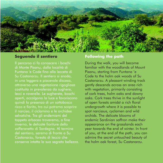
Il percorso ci fa conoscere i boschi di Monte Pisanu, dalla località di Funtana 'e Code fino alla lecceta di Su Castanarzu. Il sentiero si snoda, in una leggera e piacevole discesa, attraverso una vegetazione rigogliosa costituita in prevalenza da sughere, lecci e roverelle. Le sugherete, boschi aperti, accolgono la luce e favoriscono quindi la presenza di un sottobosco ricco e fiorito, tra cui potremo scoprire il narciso, il ciclamino e le orchidee selvatiche. Tra gli endemismi del tappeto erbaceo troveremo, a fine inverno, le delicate fioriture dello zafferanetto di Sardegna. Al termine del sentiero, saremo di fronte a Su Castanarzu, foresta di leccio che conserva intatta la sua segreta bellezza.
During the walk, you will become familiar with the woodlands of Mount Pisanu, starting from Funtana ‘e Code to the holm oak woods of Su Castanarzu. A pleasant winding track gently descends across an area rich with vegetation, primarily consisting of cork trees, holm oaks and downy oaks. Cork trees thrive in the sunlight of open forests amidst a rich floral undergrowth where it is possible to spot narcissus, cyclamen and wild orchids. The delicate blooms of endemic Sardinian saffron make their appearance on the grasslands each year towards the end of winter. In front of you, at the end of the path, you can admire the secret untouched beauty of the holm oak forest, Su Castanarzu.
Following the pathSeguendo il sentiero
3 - monte pisanu.indd 3 14-07-2008 17:10:24
Alla scoperta della Foresta
Il complesso forestale del Goceano è formato dalle tre sezioni separate di Fiorentini, Monte Pisanu e Anela. Nell'area di Fiorentini, in località Su Tassu, potremo osservare i maestosi pini larici che superano i 30 metri di altezza. Il vicino complesso demaniale di Anela, che giunge fino a mille metri di altitudine, è caratterizzato da un clima fresco e umido e da un paesaggio quasi appenninico. Infine, percorrendo una pista forestale della sezione di Monte Pisanu, arriveremo a Sos Nibberos, monumento naturale con i suoi tassi millenari. Caratteristici di questi habitat forestali sono il gatto selvatico, dal comportamento elusivo e solitario, il topo quercino e l'astore sardo, specie endemica che nidifica sugli alberi più alti della foresta. Sulle cime rocciose e sulle radure non è raro vedere volteggiare il grande corvo imperiale ed il gracchio corallino.
3 - monte pisanu.indd 4 14-07-2008 17:10:26
The Goceano forest region consists of three separate sections, Fiorentini, Monte Pisanu and Anela. In the Fiorentini area of Su Tassu, you will find the majestic larch pines, growing to more than 30 metres in height. In the neighbouring state territory of Anela, that reaches 1000 metres in altitude, the climate is fresh and humid, almost Apennine in feature. Finally, travelling along a forest track through Monte Pisanu, you will arrive at Sos Nibberos, a natural monument with its millennial yew trees. Typical of this forest habitat is the elusive and solitary wild cat, the garden dormouse (Eliomys quercinus) and the Sardinian goshawk, an endemic species that nests in the highest forest trees. Above the glades, among the rocky peaks, it is not rare to spot the large common raven and the red-billed chough gliding above.
Feautures of the Forest
3 - monte pisanu.indd 5 14-07-2008 17:10:27
Le popolazioni locali hanno sin dall'antichità utilizzato le risorse delle foreste del Goceano in modo comunitario. Dall'uso agricolo, alla raccolta della legna e al pascolo brado, queste aree costituiscono un luogo storico, dove l'ambiente ha modellato la vicenda umana.
Nel Centro Servizi della Foresta Demaniale di Monte Pisanu si trova la xiloteca sulle essenze arboree ed arbustive della Sardegna. In quello di Fiorentini viene illustrato invece il ciclo della quercia da sughero ed è possibile osservarne i prodotti.
Since ancient times, the local communities have shared the resources of the Goceano forest. From farming, to timber and the untamed pastures, these historical areas testify how the environment has moulded human lifestyles.
The Monte Pisanu State Forest Service Centre offers visitors a xiloteca (a col-lection of wood specimens and sections) of Sardinian trees and shrubs. At the Fiorentini Forest Service Center, the cork tree cycle is illustrated and it is possible to admire the cork products.
3 - monte pisanu.indd 6 14-07-2008 17:10:30
Come arrivare How to get there
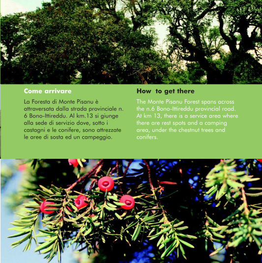
La Foresta di Monte Pisanu è attraversata dalla strada provinciale n. 6 Bono-Ittireddu. Al km.13 si giunge alla sede di servizio dove, sotto i castagni e le conifere, sono attrezzate le aree di sosta ed un campeggio.
The Monte Pisanu Forest spans across the n.6 Bono-Ittireddu provincial road. At km 13, there is a service area where there are rest spots and a camping area, under the chestnut trees and conifers.
3 - monte pisanu.indd 7 14-07-2008 17:10:31
Regione Autonoma della SardegnaEnte Foreste della Sardegna
Sistema diffuso di informazione e educazione ambientale sulle foreste della Sardegnawww.sardegnaforeste.it
3 - monte pisanu.indd 8 14-07-2008 17:10:32
Sulle vie del legno
paesaggi naturali e culturali tra i segni del passato
Foresta Demaniale Pantaleo
7 - foresta pantaleo.indd 1 14-07-2008 17:18:32
Dati sul percorso
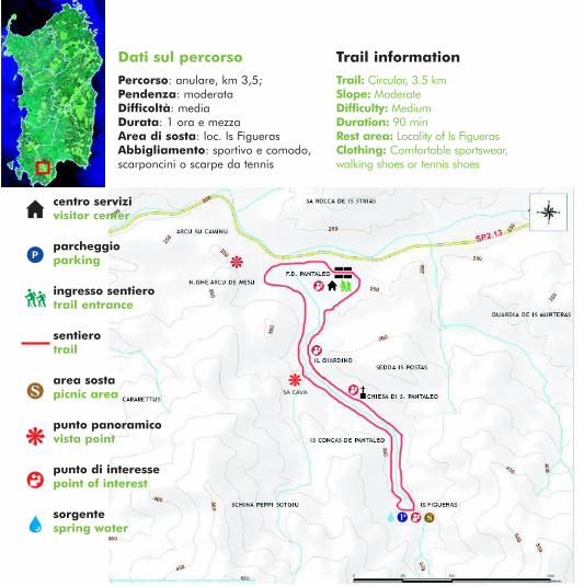
Percorso: anulare, km 3,5; Pendenza: moderata Difficoltà: media Durata: 1 ora e mezzaArea di sosta: loc. Is FiguerasAbbigliamento: sportivo e comodo, scarponcini o scarpe da tennis
Trail: Circular, 3.5 kmSlope: Moderate Difficulty: MediumDuration: 90 minRest area: Locality of Is FiguerasClothing: Comfortable sportswear, walking shoes or tennis shoes
Trail information
centro servizivisitor center
parcheggioparking
ingresso sentierotrail entrance
sentierotrail
area sostapicnic area
punto panoramicovista point
punto di interessepoint of interest
sorgentespring water
sa cava
7 - foresta pantaleo.indd 2 14-07-2008 17:18:34
Seguendo il sentiero Following the path
You leave from the Central Forest Station by crossing an area of pine reforestation which is in keeping with the natural vegetation of the area. We continue through the bush land and woods of high trunked oaks that dominate the landscape. “The garden” is the name of a locality rich with water, that was used in the past to feed the canals and sluices. The road cuts through the holm-oak grove with its ancient charcoal burning sites, reaching the ruins of the Roman thermal baths which later became the “Pantaleo Church” and ending with the Is Figueras springs. The return path descends along the left bank of the Is Figueras river to the locality of Sa Cava where we can see the structural remains of the place apparently used to weigh the wood before it was sent down to the valley, where the woodcutters were paid.
Partiamo dal Centro di Cantiere attraversando un rimboschimento con dei pini, seguito dalla vegetazione naturale dell'area, macchia e boschi di leccio avviati all'alto fusto, che poi costituiranno il paesaggio dominante. La località Il giardino è ricca d'acqua, che in passato fu sfruttata per realizzare canalizzazioni e chiuse. La strada percorre la lecceta, con le antiche carbonaie, e giunge prima ai ruderi di un edificio termale di epoca romana, in seguito denominato la “chiesa Pantaleo”, e poi alle sorgenti di Is Figueras. Il sentiero di ritorno scende in sinistra idrografica lungo il rio Is Figueras e incontra, in località sa Cava, i resti di una struttura dove pare si pesassero i prodotti ricavati dal taglio dei boschi prima di essere avviati a valle e pagati ai lavoratori.
7 - foresta pantaleo.indd 3 14-07-2008 17:18:34
Alla scoperta della Foresta
I monti del Sulcis sono coperti da una coltre continua e fitta di vegetazione, in prevalenza boschi cedui di leccio. Si tratta della più estesa lecceta dell'Europa e del Mediterraneo. Nel territorio sono presenti specie rare quali il tasso, l'agrifoglio, ed endemismi arborei quali la ginestra dell'Etna. L'habitat ospita una fauna notevole e varia il cui rappresentante più noto è forse il cervo sardo, e che comprende inoltre il gatto selvatico, la martora, la volpe e la donnola. Vi nidificano l'aquila reale e l'astore, oltre allo sparviere, al falco pellegrino ed ad altre specie più diffuse. La zona è di grande importanza per il passo degli uccelli migratori. Inoltre dal 1988 vi è stato intrapreso con buoni risultati l'allevamento sperimentale della lepre sarda.
7 - foresta pantaleo.indd 4 14-07-2008 17:18:37
Features of the Forest
The Sulcis mountains are covered with a blanket of dense vegetation dominated by deciduous holm-oak thickets. This area corresponds to the most extensive stretch of holm-oaks in Europe and the Mediterranean. The territory exhibits many rare species like yew, holly and some endemic trees such as Mount Etna broom. The ha-bitat hosts a remarkable variety of fauna, perhaps the most famous being Sardinian deer, but also comprises wildcats, martens, foxes, and weasels. It is also the nesting place of the golden eagle and goshawk amongst other more profuse species such as the sparrow-hawk and peregrine falcon. The area is of great importance as a resting place for migratory birds. Moreover, in 1988 a project was undertaken, with great success, for the experimental breeding of the Sardinian hare.
7 - foresta pantaleo.indd 5 14-07-2008 17:18:37
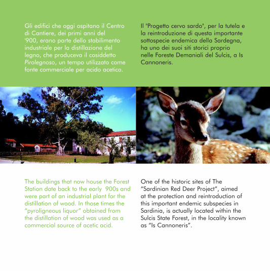
Il "Progetto cervo sardo", per la tutela e la reintroduzione di questa importante sottospecie endemica della Sardegna, ha uno dei suoi siti storici proprio nelle Foreste Demaniali del Sulcis, a Is Cannoneris.
Gli edifici che oggi ospitano il Centro di Cantiere, dei primi anni del '900, erano parte dello stabilimento industriale per la distillazione del legno, che produceva il cosiddetto Pirolegnoso, un tempo utilizzato come fonte commerciale per acido acetico.
The buildings that now house the Forest Station date back to the early ′900s and were part of an industrial plant for the distillation of wood. In those times the “pyroligneous liquor” obtained from the distillation of wood was used as a commercial source of acetic acid.
One of the historic sites of The “Sardinian Red Deer Project”, aimed at the protection and reintroduction of this important endemic subspecies in Sardinia, is actually located within the Sulcis State Forest, in the locality known as “Is Cannoneris”.
7 - foresta pantaleo.indd 6 14-07-2008 17:18:42
Come arrivare How to get there
The Pantaleo Forest Station is on the n. 1 Provincial Road and can be reached from Santadi by driving along an 8 km stretch of asphalt road. It can also be reached from S. Lucia, Capoterra, by driving for about 25 km along a dirt road.For further information, please contact the Pantaleo Forest Station, Tel: 0781955179
Il Centro di Cantiere Pantaleo si trova lungo la Strada Provinciale n. 1 e si raggiunge da Santadi in 8 km su strada asfaltata, mentre da S. Lucia di Capoterra si percorrono circa 25 km a fondo sterrato. Informazioni: Centro di Cantiere Pantaleo tel. 0781955179
7 - foresta pantaleo.indd 7 14-07-2008 17:18:44
Regione Autonoma della SardegnaEnte Foreste della Sardegna
Sistema diffuso di informazione e educazione ambientale sulle foreste della Sardegnawww.sardegnaforeste.it
7 - foresta pantaleo.indd 8 14-07-2008 17:18:45
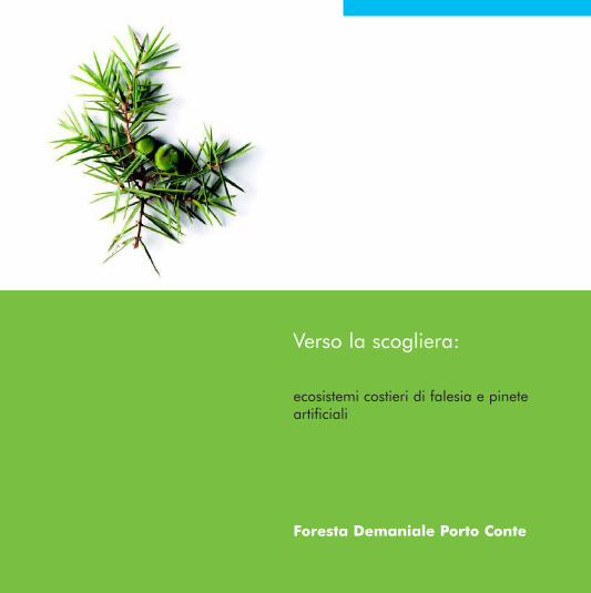
Verso la scogliera:
ecosistemi costieri di falesia e pinete artificiali
Foresta Demaniale Porto Conte
2 - Porto Conte.indd 1 14-07-2008 17:11:46
centro servizivisitor center
parcheggioparking
ingresso sentierotrail entrance
sentierotrail
area sostapicnic area
punto panoramicovista point
punto di interessepoint of interest
sorgentespring water
Dati sul percorso Trail information
Percorso: anulare, km 1,330Pendenza: pianeggianteDifficoltà: molto bassaDurata: 45' a passo lentoArea di sosta: attrezzata con tavoli e panche in località Cala LongaAbbigliamento: sportivo e comodo
Trail: Circular walk, 1.330 kmTerrain: FlatDifficulty: Very easyDuration: 45 minutes at a leisurely paceRest area: Cala Longa rest area with picnic tables and benches Clothing: Comfortable sportswear
2 - Porto Conte.indd 2 14-07-2008 17:11:48
Seguendo il sentiero Following the path
Leaving the Cala Longa “Information Point”, you follow a path which is initially dominated by the intense green of the Aleppo pines and the scent of Phoenician junipers. Proceeding towards the sea, near the spectacular cliffs, the landscape is covered with the small round shrubs typical of the coastal gariga. The return path crosses the pine forest where, amongst the more common species such as lentisk and fillirea, the brilliant colours of the endemic gorse emerge, Genista sardoa being particularly thorny. During our walk, we may encounter small herds of miniature donkeys and wild horses, sometimes even different species of deer.
Partiamo dal "Punto informazioni" di Cala longa e percorriamo il sentiero inizialmente dominato dal verde intenso del pino d'Aleppo e dai profumi del ginepro fenicio. Procedendo verso il mare, in prossimità delle spettacolari falesie dove ancora nidifica il grifone, la vegetazione è caratterizzata dai piccoli arbusti della gariga costiera. Tra questi, molte entità endemiche quali il rarissimo fiordaliso spinoso, l'astragalo dragante, il limonio, l'euforbia delle Baleari e altre ancora. Nel percorso di ritorno, il sentiero costeggia la pineta verso il mare, tra specie comuni come il lentisco e la fillirea, spiccano i colori brillanti di una ginestra endemica, particolarmente spinosa, la ginestra di Sardegna. Durante l’escursione potremmo incontrare asinelli e cavallini inselvatichiti e qualche esemplare di daino.
2 - Porto Conte.indd 3 14-07-2008 17:11:48
Alla scoperta della Foresta
La Foresta Demaniale di Porto Conte, gioiello verde incastonato nel mare di Alghero, fu chiamata dai romani per la sua bellezza "La baia delle ninfe". La penisola di capo Caccia, che sembra nascere dall'acqua, è una terra molto antica, ricca di fenomeni carsici, sia di superficie che profondi, quali grotte, inghiottitoi e cunicoli che si affacciano sulla scogliera. Tra tutti spicca per imponenza e spettacolarità la falesia di Punta Cristallo (326 m. s.l.m.). La zona, conosciuta come "Arca", è un'Oasi permanente di protezione faunistica, dove le foreste di pino d'Aleppo e pino domestico furono piantate per proteggere la ricrescita della macchia mediterranea e in cui furono immessi i daini, i cavallini della Giara e gli asinelli bianchi dell'isola Asinara. Qui, in suggestiva e perfetta armonia, i profumi delle resine dei pini si mescolano alle fragranze marine portate dal vento.
2 - Porto Conte.indd 4 14-07-2008 17:11:53
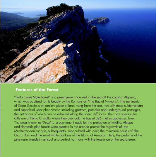
Features of the Forest
“Porto Conte State Forest” is a green jewel mounted in the sea off the coast of Alghero, which was baptized for its beauty by the Romans as “The Bay of Nymphs”. The peninsular of Capo Caccia is an ancient piece of land rising from the sea, rich with deep subterranean and superficial karst phenomena including grottoes, potholes and underground passages, the entrances of which can be admired along the sheer cliff faces. The most spectacular cliffs are at Punta Cristallo where they overlook the bay at 326 metres above sea level. The area known as “Arca” is a permanent oasis for the protection of wildlife. Aleppo and domestic pine forests were planted in the area to protect the regrowth of the Mediterranean maquis, subsequently repopulated with deer, the miniature horses of the Giara Plain and the small white donkeys of the Island of Asinara. Here, the perfume of the pine resin blends in sensual and perfect harmony with the fragrance of the sea breeze.
2 - Porto Conte.indd 5 14-07-2008 17:11:54
Le Grotte di Nettuno, raggiungibili in barcone o dalla caratteristica Escala del Cabirol, sono una delle maggiori attrattive turistiche della zona. Nelle cavità delle pareti verticali trovano rifugio e nidificano le berte, l'uccello delle tempeste e il falco pellegrino.
Il fiordaliso spinoso è considerato un paleoendemismo, ed è presente nel mondo solo in Sardegna, nella penisola di Capo Caccia e nelle isole di Asinara e Tavolara. Specie relitta vegetale, testimonia l'era in cui l'isola era ancora unita al continente.
The Neptune caves are a major tourist attraction and can be reached by boat or the peculiar Cabirol Staircase. In the cavities of the cliff face, the berte, shearwater and peregrine falcons find refuge and nesting places.
Here, the spiny Lily grows and is considered to be a paleoendemic species. It can only be found in Sardinia, on the peninsula of Capo Caccia and on the islands of Asinara and Tavolara. This stranded species of plant life is testimony to the time when Sardinia was still part of the European continent.
2 - Porto Conte.indd 6 14-07-2008 17:11:57
Come arrivare How to get there
Da Sassari si prende la SS 291 per Alghero fino al nuraghe Sant'Imbenia, per raggiungere Capo Caccia. Accesso alla Foresta: dal lunedì al venerdì dalle 9.00 alle 16.00 e il sabato e la domenica dalle 9.00 alle 17.00. Ufficio Informazioni tel. 079 949060
Leave Sassari by taking the SS 291 state road to Alghero until you reach the Nura-ghe village of Sant’Imbenia. From there, follow the signs to Capo Caccia. Forest entrance times: Monday to Friday from 9am to 4pm; Saturdays and Sundays from 9am to 5pm. For further information, please telephone 079 949060
2 - Porto Conte.indd 7 14-07-2008 17:11:59
Regione Autonoma della SardegnaEnte Foreste della Sardegna
Sistema diffuso di informazione e educazione ambientale sulle foreste della Sardegnawww.sardegnaforeste.it
2 - Porto Conte.indd 8 14-07-2008 17:12:00
Regione Autonoma della SardegnaEnte Foreste della Sardegna
Sistema diffuso di informazione e educazione ambientale sulle foreste della Sardegnawww.sardegnaforeste.it
InforestaInforesta is a project set up the Forest Agency and the Assessorate for the Environment of the Sardinian Regional Government. The project aims at contributing to activities focused on the divulgation of information, public awareness and environmental education. The project targets schools and associations involved in environmental teaching activities. The formation program concentrates on 6 different environmental themes that are developed across a didactic network spanning the main state forests. A net of Service Centres within these forests have shown interest in the program and will provide the necessary logistic support
InforestaInforesta è un progetto dell'Ente Foreste e dell'Assessorato Difesa Ambiente della Regione Sardegna che ha come finalità quella di contribuire alla attività di informazione, divulgazione, sensibilizzazione ed educazione ambientale. L’iniziativa è rivolta a scuole e alle associazioni impegnate in attività didattiche sui temi ambientali. Il programma formativo affronta sei aree tematiche e si sviluppa attraverso una rete di sentieri didattici dislocati all’interno delle principali foreste demaniali. Una rete di Centri Servizi, dislocati nelle foreste interessate al programma, fornisce il supporto ogistico necessario.