84
Gargano’s sandy, pebbly Beaches Sabbia, ghiaia, ciottoli Azienda di Promozione Turistica della Provincia di Foggia le Spiagge del
Gargano’s sandy, pebbly Beaches
Sabbia, ghiaia, ciottoli
Azienda di Promozione Turisticadella Provincia di Foggia
le Spiagge del
Si ringrazia per la gentile collaborazione:For the grateful contribution thanks to:
per il comune di Cagnano Varano Beraradino Bocale
per il comune di Ischitella Giuseppe Derrico (Presidente Associazione Turistica Ambientale Varano) Dottor Leo La Malva (Assessore Turismo e Sport)
per il comune di Vico del Gargano Avvocato Massimo Fiorentino (Assessore ai lavori pubblici) Raffaele Lamonaca Giovanni Cassa
per il comune di Peschici Vincenzo Denittis (Assessore Turismo e Sport) Gabriele Draicchio
per il comune di Vieste Ingegnere Giuseppe Armellino (Studio Tecnico ArKingegno) Agenzia viaggi vieste.it - Via C. dell’Erba n° 4 - 71019 Vieste (FG) Sito web: www.vieste.it - e-mail: [email protected] - Tel.: 0884.701080
per il comune di Mattinata Pierpaolo D’Arienzo Lorenzo Di Mauro
Un particolare ringraziamento a:Special thanks to:
Giuseppe Disanti (maestro), Dottor Angelo Raffaele Guglielmi (GTOURS), Maria Grazia Dirodi (maestra),Tonino Vitarelli (operatore turistico in Mattinata), Remo Rainone (Studio Tecnico Kartographia)
Si ringraziano inoltre per la fornitura di materiale fotografico i seguenti operatori:For available photographs thanks to:
Archivio fotografico APT-Foggia, Nicola De Marco, Gruppo Saccia, Vincenzo Toma, Vincenzo Derrico,Domenico Damato, P.I. Giuseppe Bonsanto, Dante Ottolini, Paolo Lorusso, Luigi Manzionna,Girolamo Notarangelo, Girolamo Notarangelo, Natale Corso, Stefano Martucci, Gruppo Sacco,Gaetano Lavacca, Carlo Ranalli, Franco Iaconeta, Berardino Mione (Foto Studio Dettagli),Antonio Giuliani, Michele Fusillo, Marino Solitro, Mario Turi, Francesca Palmucci, Pasquale Tatalo
Fotoaeree e cartografia:Aerial photos and cartography:
Cartografia Tecnica Regionale (ortofoto) - www.sit.puglia.it
TraduzioniTranslations
Agenzia SOL sasdi Abbattista T. R. (Vieste)Tel. 340.9062046www.solvieste.it
Grafica e stampaLayout and print
Grafiche GrilliVia Manfredonia, km 2,20071100 FoggiaTel. 0881.56.80.40 - Fax [email protected]
Iniziativa finanziata con fondi UE.Linee di intervento misura 4.15 POR Puglia 2000/2006 Progetto “Città Aperte”
UNIONE EUROPEA REGIONE PUGLIA
5
The Gargano, well-known all over the province of Foggia, Italy and abroad for tourism is also considered for its coast, one of the most important Italy’s naturalistic patrimony.Its coast, approximately 140 km long, embellished with a great number of beaches, inlets, bays and caves gives us the opportunity to work at this project, a guidebook, that can be used by thousands of travellers, who visit our region every year.The aim of this booklet is to make it possible for dedica-ted visitors to explore and better spend their holiday at seaside.This work depicts our region, as well as our coast and sea, with a description of beaches, inlets and bays, which are favourite destinations of summer tourism.This guidebook, planned and published by the Foggia Tourist Board employees, promotes Gargano’s territory. Now I say enjoy Your holiday and our marvellous beaches.
Commissary of Foggia Tourist Board Mr Nicola Vascello
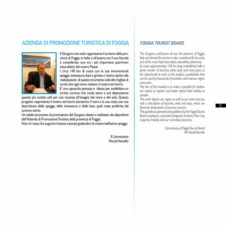
Il Gargano non solo rappresenta il turismo della pro-vincia di Foggia, in Italia e all’estero, ma il suo litorale è considerato uno tra i più importanti patrimoni naturalistici del nostro Paese.I circa 140 km di costa con le sue innumerevoli spiagge, insenature, baie e grotte ci hanno spinto alla realizzazione di questo strumento utile alle migliaia di turisti che ogni anno visitano il nostro territorio.E’ uno opuscolo pensato e ideato per soddisfare un turista curioso che vuole avere a sua disposizione
quante più notizie utili per una vacanza all’insegna del mare e del sole. Questo progetto rappresenta il nostro territorio attraverso il mare e la sua costa con una descrizione delle spiagge, delle insenature e delle baie, quali mete preferite dal turismo estivo. Un valido strumento di promozione del Gargano ideato e realizzato dai dipendenti dell’Azienda di Promozione Turistica della provincia di Foggia. Non mi resta che augurarvi buone vacanze godendovi le nostre bellissime spiagge.
Il Commissario Nicola Vascello
AZIENDA DI PROMOZIONE TURISTICA DI FOGGIA FOGGIA TOURIST BOARD
6
UFFICI TURISTICI DELLA PROVINCIA DI FOGGIA
InFormAzIone e AccoglIenzA TurIsTIcA - locAl TourIsT oFFIce VerkehrsVereIn - syndAcAT d’InITIATIVe
APT “AzIendA dI PromozIone TurIsTIcA dellA ProVIncIA dI FoggIA”Via E. Perrone, 17CAP 71100 FoggiaTel. 0881.723141 - Fax. 0881.725536www.viaggiareinpuglia.ite-mail: [email protected]
mAnFredonIA Piazza della Libertà, c/o stazione F.SCAP 71043Tel. e Fax 0884.581998e-mail: [email protected]
mArgherITA dI sAVoIAVia Principe Amedeo, 4CAP 71044Tel. 0883.654012e-mail: [email protected]
mATTInATACorso Matino, 68CAP 71030Tel. 0884.559169 - Fax. 0884.550013
PeschIcIVia Magenta, 3CAP 71013Tel. e Fax 0884.915362
sAn gIoVAnnI roTondo Piazza Europa, 104CAP 71013Tel. e Fax. 0882.456240e-mail: [email protected]
TroIAPiazza Giovanni XXIIICAP 71029Tel. 0881.970020
VIesTePiazza KennedyCAP 71019Tel. 0884.708806 / 707495 - Fax 0884.704511e-mail: [email protected]
7
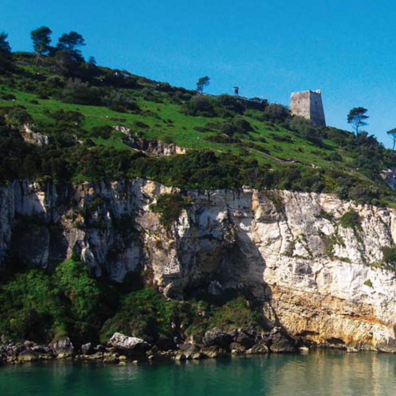
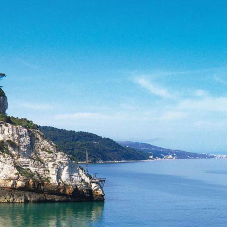
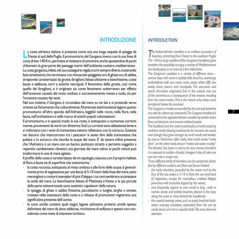
La costa adriatica italiana si presenta come una una lunga sequela di spiagge da Trieste al sud della Puglia. Il promontorio del Gargano, invece, con la sua linea di
costa di ben 140 Km., permette al visitatore di ammirare, anche spostandosi di pochi chilometri, la gran parte dei paesaggi marini dell’ambiente costiero mediterraneo.La costa garganica, infatti, nel suo susseguirsi regala scorci sempre diversi, mostrando baie strettissime che terminano con minuscole spiaggette ora di ghiaia ora di sabbia, strapiombi caratterizzati da grotte, faraglioni, falesie altissime e bianchissime, coste basse e sabbiose, torri e antiche necropoli. Il fenomeno delle grotte, così come quello dei faraglioni, si è originato sia come fenomeno sotterraneo per effetto dell’erosione causata dal moto ondoso e successivamente messe a nudo, sia per l’erosione causata dai venti.Nel suo insieme, il Gargano è circondato dal mare su tre lati e si protende verso oriente sia fisicamente che culturalmente. Numerose testimonianze legano questo promontorio all’altra sponda dell’Adriatico, leggibili nelle rocce, nella flora, nella fauna, nell’architettura e nelle tracce di antichi popoli colonizzatori.Il promontorio, e in special modo la sua costa, è sottoposto a numerose correnti marine, provenienti da nord con direttrice Sud. Le correnti sono abbastanza lente e si rinforzano con i venti di tramontana mentre rallentano con lo scirocco. Sovente nei discorsi che intercorrono tra i pescatori si sente dire della tramontana che pulisce e lo scirocco che intorba le acque del mare. E’ da tenere infine presente che l’Adriatico è un mare con un bacino piuttosto stretto e pertanto soggetto a repentini cambiamenti climatici: una giornata dal mare calmo in pochi minuti può trasformarsi in una di mare agitato.Il profilo della costa è caratterizzato da tre tipologie, ciascuna con il proprio habitat, di flora e fauna sia di superficie che sottomarina:- la costa rocciosa, sottoposta al moto ondoso e alle furie delle acque, è general-
mente priva di vegetazione per una fascia di 5-10 metri dalla linea del mare, salvo meravigliosi e contorti esemplari di pini d’aleppo i cui rami sembrano accarezzare le onde del mare. Le bianchissime falesie di Mattinata e Vieste o le più piccole della parte settentrionale sono autentici capolavori della natura;
- le spiagge, di ghiaia o sabbia finissima, piccolissime o lunghe, larghe o strette, createsi nelle insenature della costa o a ridosso di promontori registrano una significativa presenza dell’uomo;
- le zone umide costiere quali stagni, lagune salmastre, praterie umide spesso delimitate dal mare da dune sabbiose, ricchissime di avifauna e spesso non con-siderate come meta di interesse turistico.
The Italian Adriatic coastline is an endless succession of beaches, stretching from Trieste to the southern Puglia.
The 140 km long coastline of the Gargano’s headland gives travellers the possibility to enjoy a variety of Mediterranean sea landscapes, in an area of a few kilometres. The Gargano’s coastline is a variety of different views – narrow bays with sand or pebbly little beaches, overhangs embroidered with sea caves, rocks, steep white cliffs, low sandy shore, towers and necropolis. The sea-caves and stacks formation originated first in the subsoil, rose out of the sea-level, as a consequence of the erosion, resulting from the wave-motion. This is the reason why many caves are placed below the sea-level. The Gargano is mostly surrounded by the sea and stretches out, with its culture too, eastwards. The Gargano headland is connected to the opposite Adriatic coastline by similar rocks, flora, architecture and ancient civilised people.The headland, and the coast in particular, is mainly swept by northern winds blowing southwards. Air streams are weak, even though they grow stronger by north winds and weaker by sirocco. Fishermen often state, that north winds “make clear”, on the other hand, sirocco “makes sea water muddy”. The Adriatic Sea basin is said to be very narrow, therefore it is exposed to sudden climatic changes. A day of calm sea can turn into a rough one.Three different kinds of shoreline can be compared, identi-fied by different surface, sea flora and fauna habitat:- the rocky shoreline, pounded by the waves and by the
fury of the sea water, is 5-10 m from the sea level bare of vegetation, except for marvellous crabbed Aleppo pine-trees with branches lapped by the waves;
- very frequently appear to men small or long , wide or narrow sandy and pebbly beaches, placed in the bays along the coast or close behind the headlands;
- the coastal swampy areas, such as pools, brackish back-water, swampy meadows, separated from the sea by sandy dunes, are rich in aquatic birds. This area deserves attention.
INTRODUZIONE INTRODUCTION
8
GEN
NA
IOJA
NU
ARy
FEB
BR
AIO
FEB
RU
ARy
MA
RZO
MA
RCh
APR
ILE
APR
IL
MAG
GIO
MAy
GIU
GN
OJU
NE
LUG
LIO
JULy
AGO
STO
AUG
UST
SETT
EMB
RE
SEPT
EMB
ER
OTTO
BR
EO
CTO
BER
NOV
EMB
RE
NOV
EMB
ER
DIC
EMB
RE
DEC
EMB
ER
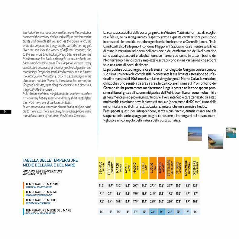
TEMPERATURE MASSIMEMAxIMUM TEMPERATURE 11.3° 11.7° 13.2° 16.5° 20.7° 24.5° 27.3° 27.6° 24.7° 20.3° 16.2° 12.9°
TEMPERATURE MINIMEMINIMUM TEMPERATURE 7.1° 7.1° 8.4° 11.2° 15.0° 18.9° 21.5° 21.8° 19.2° 15.3° 11.7° 8.7°
TEMPERATURE MEDIEMEDIUM TEMPERATURE 9.2° 9.4° 10.8° 13.9° 17.9° 21.7° 24.5° 24.7° 22.0° 17.8° 13.9° 10.8°
TEMPERATURE MEDIE DEL MARESEA MEDIUM TEMPERATURE 14° 12° 14° 16° 17° 19° 23° 24° 21° 20° 19° 14°
TABELLA DELLE TEMPERATURE MEDIE DELL’ARIA E DEL MAREAIR AND SEA TEMPERATUREAVERAGE ChART
La scarsa accessibilità della costa garganica tra Vieste e Mattinata, formata da scoglie-re e falesie, ne ha salvaguardato l’aspetto; grazie a questa caratteristica persistono interessanti elementi del mondo vegetale ed animale come la Coronilla Juncea, l’Inula Candida il Falco Pellegrino, il Rondone Maggiore, il Gabbiano Reale mentre sulla linea di mare le variazioni ad opera dell’erosione e del cambiamento del livello marino sono assai spettacolari e talvolta nette. Le maree, così come in tutto il bacino del Mediterraneo, hanno scarsa ampiezza e si traducono in una variazione che scopre solo una zona di pochi decimetri.La particolare posizione geofisica e la stessa morfologia del Gargano conferiscono al suo clima una notevole complessità. Nonostante la sua limitata estensione ed un’al-titudine massima di 1065 metri s.m.l. che si raggiunge sul Monte Calvo, le variazioni climatiche sono sensibili da area a area. In particolare il clima sul Promontorio del Gargano risulta prettamente mediterraneo lunga la costa e nelle zone appena pros-sime ai litorali grazie all’azione mitigatrice dell’Adriatico. I litorali sono molto miti e generalmente poco piovosi, in particolare il versante Sud è caratterizzato da estati molto calde e siccitose dove la piovosità annuale (poco meno di 400 mm) è una delle minori italiane ed il clima resta abbastanza mite anche nel semestre freddo.Presupposti questi per intraprendere, senza alcun rischio, entusiasmanti gite alla scoperta delle varie spiagge per meglio conoscere e immergersi nel nostro mera-viglioso e unico angolo della natura della costa adriatica.
The lack of service roads between Vieste and Mattinata, has preserved the territory, riddled with cliffs, so that interesting plants and animals still live, such as the crown vetch, the white elecampene, the peregrine, the swift, the herring-gull. Over the sea level the variety of different sceneries, due to the erosion, is breathtaking. Neap tides are all over the Mediterranean Sea basin, a change in the sea level only, that bares small coastline areas. The Gargano’s climate is very complicated, because of its peculiar geophysical position and morphology. Despite its small-sized territory and its highest mountain, Calvo Mountain (1065 m a.s.l.), changes in the climate are notable. Thanks to the Adriatic Sea current, the Gargano’s climate, right along the coastline and close to it, is typically Mediterranean. Mild climate and short rainfall mark the southern coastline: it means very hot dry summer and yearly short rainfall (less than 400 mm), one of the lowest in Italy.In late autumn and winter the climate is also mild, it is possi-ble to make excursions searching for beaches, placed in this marvellous corner of nature on the Adriatic Sea coast.
9
CAPOIALE FOCE VARANO LIDO DEL SOLE SAN MENAIO PESCHICI BIVIO UMBRA MARE VIESTE TESTA DEL GARGANO PUGNOCHIUSO BIVIO SANTA TECLA BAIA DELLE ZAGARE MATTINATA km 0,0 km 5,61 km 10,6 km 12,47 km 23,35 km 30,85 km 47,53 km 53,93 km 62,33 km 72,59 km 77,49 km 87,02 km 102,47
CAGNANO VARANO ISCHITELLA RODI GARGANICO VICO DEL GARGANO PESCHICI VIESTE MATTINATA
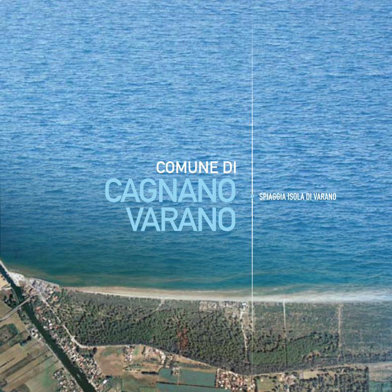
COMUNE DI
CAGNANOVARANO
• SPIAGGIA ISOLA DI VARANO
10
CAPOIALE FOCE VARANO LIDO DEL SOLE SAN MENAIO PESCHICI BIVIO UMBRA MARE VIESTE TESTA DEL GARGANO PUGNOCHIUSO BIVIO SANTA TECLA BAIA DELLE ZAGARE MATTINATA km 0,0 km 5,61 km 10,6 km 12,47 km 23,35 km 30,85 km 47,53 km 53,93 km 62,33 km 72,59 km 77,49 km 87,02 km 102,47
CAGNANO VARANO ISCHITELLA RODI GARGANICO VICO DEL GARGANO PESCHICI VIESTE MATTINATA
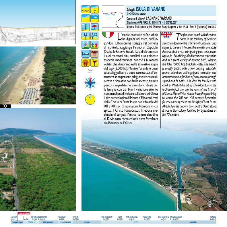
L’arenile, costituito di fine sabbia che digrada nel mare, prolun-
gandosi sull’omonima spiaggia del comune di Ischitella, raggiunge l’istmo di Capoiale. Ospita la Riserva Statale Isola di Varano con i suoi maestosi pini, eucalipti e una ridente macchia mediterranea nonché i numerosi volatili che dimorano nelle salmastre acque del lago (6.000 ha). Mentre l’arenile è quasi tuta spiaggia libera e poco attrezzato, nell’en-troterra sono presenti adeguate strutture ri-cettive e ricreative con facile accesso, tramite percorsi segnalati che la rendono ideale per le famiglie con bambini. Il visitatore attento non mancherà di visitare sull’altura ad Ovest il sito archeologico di Monte d’Elio con i resti della Chiesa di Santa Maria con affreschi del XII e XIII sec. di ispirazione bizantina in cui spicca il Cristo Pantocrator. In epoca me-dievale vi sorgeva l’antico centro cittadino di Devia nato come colonia slava fortificata dai Bizantini nell’XI sec.
The fine sand beach with the same name in the territory of Ischitella
stretches down to the isthmus of Capoiale and slopes to the sea. It houses the Isola Varano State Reserve, that is rich in imposing pine trees, euca-lyptus, in flourishing Mediterranean vegetation and in a great variety of aquatic birds, living in the lake (6000 ha) brackish water. The beach is mostly public with a few bathing establish-ments. Inland are well-equipped recreation and accommodation facilities of easy access through signed and fit paths. It is ideal for families with children. West of the top of Elio Mountain in the archaeological site, are the ruins of the Church of Santa Maria. Wise visitors have the possibility to watch the XII and XIII century Byzantine frescoes among these the Almighty Christ. In the Middle Age the ancient town centre Devia stood, it was a Slav colony, fortified by Byzantines in the XI century.
spiaggia IsolA dI VArAnoIsola Varano beachcomune di (Town): CAGNANO VARANOriferimento gPs (gPs): n. 41’54,875’ - e. 015’43,601’distanza fra i comuni vicini (distance from): cagnano V. km 17,30 - Foce V. (Ischitella) km 5,03
5,480 60
NordNorth
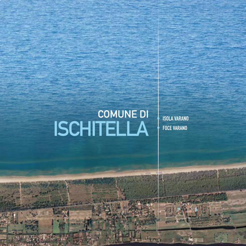
COMUNE DI
ISChITELLA
ISOLA DI VARANO
11
CAPOIALE FOCE VARANO LIDO DEL SOLE SAN MENAIO PESCHICI BIVIO UMBRA MARE VIESTE TESTA DEL GARGANO PUGNOCHIUSO BIVIO SANTA TECLA BAIA DELLE ZAGARE MATTINATA km 0,0 km 5,61 km 10,6 km 12,47 km 23,35 km 30,85 km 47,53 km 53,93 km 62,33 km 72,59 km 77,49 km 87,02 km 102,47
CAGNANO VARANO ISCHITELLA RODI GARGANICO VICO DEL GARGANO PESCHICI VIESTE MATTINATA
COMUNE DI
ISChITELLA• ISOLA VARANO
• FOCE VARANO
12
CAPOIALE FOCE VARANO LIDO DEL SOLE SAN MENAIO PESCHICI BIVIO UMBRA MARE VIESTE TESTA DEL GARGANO PUGNOCHIUSO BIVIO SANTA TECLA BAIA DELLE ZAGARE MATTINATA km 0,0 km 5,61 km 10,6 km 12,47 km 23,35 km 30,85 km 47,53 km 53,93 km 62,33 km 72,59 km 77,49 km 87,02 km 102,47
CAGNANO VARANO ISCHITELLA RODI GARGANICO VICO DEL GARGANO PESCHICI VIESTE MATTINATA
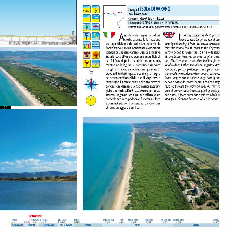
Antichissima lingua di sabbia che ha causato la formazione
del lago dividendolo dal mare, che va da Foce Varano sino alla confinante e omonima spiaggia di Cagnano Varano. Ospita la Riserva Statale Isola di Varano con una superficie di ha 154 fatta di pini e macchia mediterranea, mentre nella laguna si possono osservare tra gli altri volatili i cormorani, gli svassi, i piovanelli tridatti, i quattrocchi e gli smergi e nel bosco occhioni, silvie, cuculi, volpi, tassi e tartarughe. L’arenile, quasi del tutto privo di concessioni demaniali, è facilmente raggiun-gibile tramite la S. P. n. 41 attraverso numerosi ingressi segnalati, con un cancellato e un comodo sentiero pedonale. Esposta a Nord è dominata da venti settentrionali, ideali per chi ama veleggiare con il surf.
It is a very ancient sandy strip, that have caused the formation of the
lake, by separating it from the sea. It stretches from the Varano Mouth down to the Cagnano Varano beach. It houses the 154 ha wide Isola Varano State Reserve, an area of pine trees and Mediterranean vegetation. Habitat for a lot of birds and other animals, among these are: sea crows, grebes, goldeneyes , mergansers, in the wood stone-curlews, white throats, cuckoos, foxes, badgers and tortoises. A large part of the beach is not under State license, it can be easily reached through the provincial road 41, from it several service roads branch, signed by railings and paths. It faces north and northern winds, is ideal for surfers and for those, who love nature.
4,800 55
NordNorth
spiaggia di IsolA dI VArAnoIsola Varano beachcomune di (Town): ISCHITELLAriferimento gPs (gPs): n. 41’55,152’ - e. 015’47,287’distanza fra i comuni vicini (distance from): Ischitella km 10,5 - rodi garganico km 7,4
ISOLA DI VARANO
13
CAPOIALE FOCE VARANO LIDO DEL SOLE SAN MENAIO PESCHICI BIVIO UMBRA MARE VIESTE TESTA DEL GARGANO PUGNOCHIUSO BIVIO SANTA TECLA BAIA DELLE ZAGARE MATTINATA km 0,0 km 5,61 km 10,6 km 12,47 km 23,35 km 30,85 km 47,53 km 53,93 km 62,33 km 72,59 km 77,49 km 87,02 km 102,47
CAGNANO VARANO ISCHITELLA RODI GARGANICO VICO DEL GARGANO PESCHICI VIESTE MATTINATA
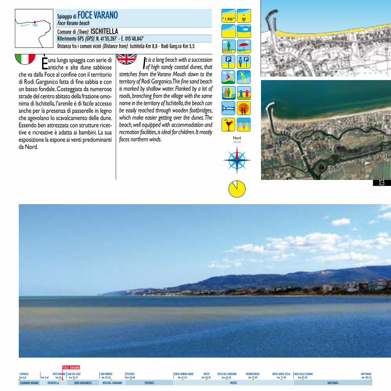
È una lunga spiaggia con serie di antiche e alte dune sabbiose
che va dalla Foce al confine con il territorio di Rodi Garganico fatta di fine sabbia e con un basso fondale. Costeggiata da numerose strade del centro abitato della frazione omo-nima di Ischitella, l’arenile è di facile accesso anche per la presenza di passerelle in legno che agevolano lo scavalcamento delle dune. Essendo ben attrezzata con strutture ricet-tive e ricreative è adatta ai bambini. La sua esposizione la espone ai venti predominanti da Nord.
It is a long beach with a succession of high sandy coastal dunes, that
stretches from the Varano Mouth down to the territory of Rodi Garganico. The fine sand beach is marked by shallow water. Flanked by a lot of roads, branching from the village with the same name in the territory of Ischitella, the beach can be easily reached through wooden footbridges, which make easier getting over the dunes. The beach, well equipped with accommodation and recreation facilities, is ideal for children. It mostly faces northern winds.
1.950 50
NordNorth
spiaggia di Foce VArAnoFoce Varano beachcomune di (Town): ISCHITELLAriferimento gPs (gPs): n. 41’55,287’ - e. 015’48,847’distanza fra i comuni vicini (distance from): Ischitella km 8,8 - rodi garg.co km 5,5
FOCE VARANO
15
CAPOIALE FOCE VARANO LIDO DEL SOLE SAN MENAIO PESCHICI BIVIO UMBRA MARE VIESTE TESTA DEL GARGANO PUGNOCHIUSO BIVIO SANTA TECLA BAIA DELLE ZAGARE MATTINATA km 0,0 km 5,61 km 10,6 km 12,47 km 23,35 km 30,85 km 47,53 km 53,93 km 62,33 km 72,59 km 77,49 km 87,02 km 102,47
CAGNANO VARANO ISCHITELLA RODI GARGANICO VICO DEL GARGANO PESCHICI VIESTE MATTINATA
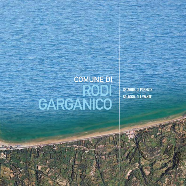
COMUNE DI
RODIGARGANICO
• SPIAGGIA DI PONENTE
• SPIAGGIA DI LEVANTE
16
CAPOIALE FOCE VARANO LIDO DEL SOLE SAN MENAIO PESCHICI BIVIO UMBRA MARE VIESTE TESTA DEL GARGANO PUGNOCHIUSO BIVIO SANTA TECLA BAIA DELLE ZAGARE MATTINATA km 0,0 km 5,61 km 10,6 km 12,47 km 23,35 km 30,85 km 47,53 km 53,93 km 62,33 km 72,59 km 77,49 km 87,02 km 102,47
CAGNANO VARANO ISCHITELLA RODI GARGANICO VICO DEL GARGANO PESCHICI VIESTE MATTINATA
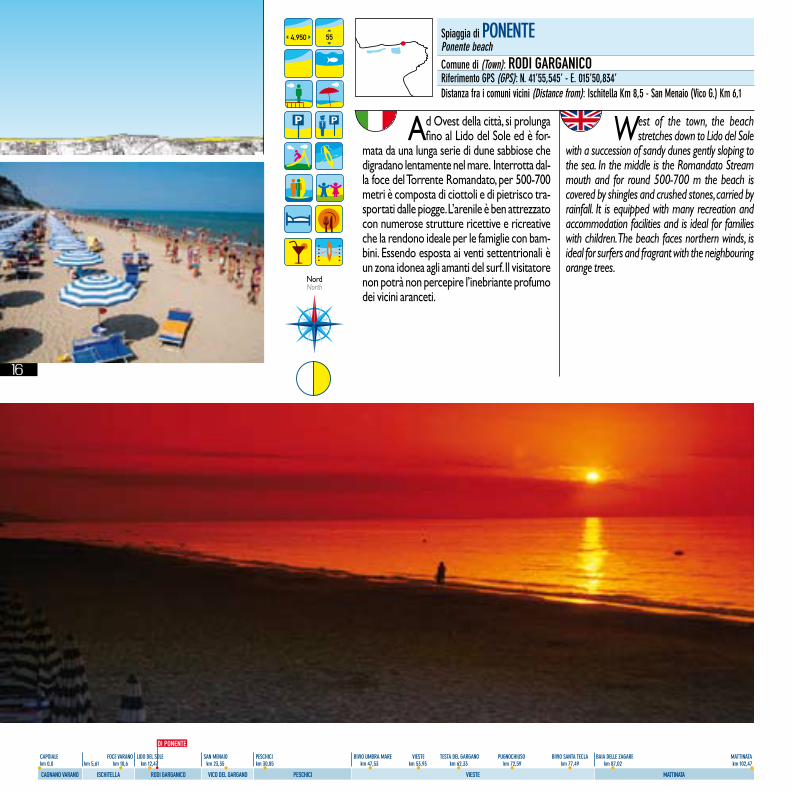
Ad Ovest della città, si prolunga fino al Lido del Sole ed è for-
mata da una lunga serie di dune sabbiose che digradano lentamente nel mare. Interrotta dal-la foce del Torrente Romandato, per 500-700 metri è composta di ciottoli e di pietrisco tra-sportati dalle piogge. L’arenile è ben attrezzato con numerose strutture ricettive e ricreative che la rendono ideale per le famiglie con bam-bini. Essendo esposta ai venti settentrionali è un zona idonea agli amanti del surf. Il visitatore non potrà non percepire l’inebriante profumo dei vicini aranceti.
West of the town, the beach stretches down to Lido del Sole
with a succession of sandy dunes gently sloping to the sea. In the middle is the Romandato Stream mouth and for round 500-700 m the beach is covered by shingles and crushed stones, carried by rainfall. It is equipped with many recreation and accommodation facilities and is ideal for families with children. The beach faces northern winds, is ideal for surfers and fragrant with the neighbouring orange trees.
4,950 55
NordNorth
spiaggia di PonenTePonente beachcomune di (Town): RODI GARGANICOriferimento gPs (gPs): n. 41’55,545’ - e. 015’50,834’distanza fra i comuni vicini (distance from): Ischitella km 8,5 - san menaio (Vico g.) km 6,1
DI PONENTE

17
CAPOIALE FOCE VARANO LIDO DEL SOLE SAN MENAIO PESCHICI BIVIO UMBRA MARE VIESTE TESTA DEL GARGANO PUGNOCHIUSO BIVIO SANTA TECLA BAIA DELLE ZAGARE MATTINATA km 0,0 km 5,61 km 10,6 km 12,47 km 23,35 km 30,85 km 47,53 km 53,93 km 62,33 km 72,59 km 77,49 km 87,02 km 102,47
CAGNANO VARANO ISCHITELLA RODI GARGANICO VICO DEL GARGANO PESCHICI VIESTE MATTINATA
Il lungo arenile si trova ad Est della città ed è fatto di una fine sab-
bia dorata che digrada dolcemente nel mare. Dominata ad Ovest dalla città appollaiata sul costone roccioso è fiancheggiata sia dalla S. S. 89 che dalla Ferrovia del Gargano e arricchita dal moderno e attrezzato porto turistico. La baia citata da D’Annunzio è “tutta coperta da una selva di aranci e limoni” circondata da giardini che addolciscono e profumano il paesaggio. Di facile accesso è attrezzata con strutture ricettive e balneari che la rendono adatta ai bambini.
East of the town, the long golden fine sand beach gently slopes
to the sea. Overlooked by the town, perched on the cliff, it is flanked both by the State Road 89 and the Gargano Railway and enriched with the new well-equipped marina. The bay, mentioned by D’Annunzio, “ it is fully covered with orange and lemon trees”, is very pleasant and fragrant with the gardens, that enclose it. Of easy access, the beach is well-equipped with accommodation facilities and bathing establishments, ideal for children.
3,810 80
NordNorth
spiaggia di leVAnTelevante beachcomune di (Town): RODI GARGANICOriferimento gPs (gPs): n. 41’55,792’ - e. 015’53,960’distanza fra i comuni vicini (distance from): Ischitella km 14,5 - san menaio (Vico g.) km 1,4
DI LEVANTE
18
CAPOIALE FOCE VARANO LIDO DEL SOLE SAN MENAIO PESCHICI BIVIO UMBRA MARE VIESTE TESTA DEL GARGANO PUGNOCHIUSO BIVIO SANTA TECLA BAIA DELLE ZAGARE MATTINATA km 0,0 km 5,61 km 10,6 km 12,47 km 23,35 km 30,85 km 47,53 km 53,93 km 62,33 km 72,59 km 77,49 km 87,02 km 102,47
CAGNANO VARANO ISCHITELLA RODI GARGANICO VICO DEL GARGANO PESCHICI VIESTE MATTINATA
19
CAPOIALE FOCE VARANO LIDO DEL SOLE SAN MENAIO PESCHICI BIVIO UMBRA MARE VIESTE TESTA DEL GARGANO PUGNOCHIUSO BIVIO SANTA TECLA BAIA DELLE ZAGARE MATTINATA km 0,0 km 5,61 km 10,6 km 12,47 km 23,35 km 30,85 km 47,53 km 53,93 km 62,33 km 72,59 km 77,49 km 87,02 km 102,47
CAGNANO VARANO ISCHITELLA RODI GARGANICO VICO DEL GARGANO PESCHICI VIESTE MATTINATA
COMUNE DI
VICO DELGARGANO
• SPIAGGIA DI SAN MENAIO
• SPIAGGIA DEI CENTO SCALINI
O DELLE TUFARE
• SPIAGGIA DI MURGIA
DELLA MADONNA - SOSPETTO
• SPIAGGIA DI CALENELLE
20
CAPOIALE FOCE VARANO LIDO DEL SOLE SAN MENAIO PESCHICI BIVIO UMBRA MARE VIESTE TESTA DEL GARGANO PUGNOCHIUSO BIVIO SANTA TECLA BAIA DELLE ZAGARE MATTINATA km 0,0 km 5,61 km 10,6 km 12,47 km 23,35 km 30,85 km 47,53 km 53,93 km 62,33 km 72,59 km 77,49 km 87,02 km 102,47
CAGNANO VARANO ISCHITELLA RODI GARGANICO VICO DEL GARGANO PESCHICI VIESTE MATTINATA
2,550 60
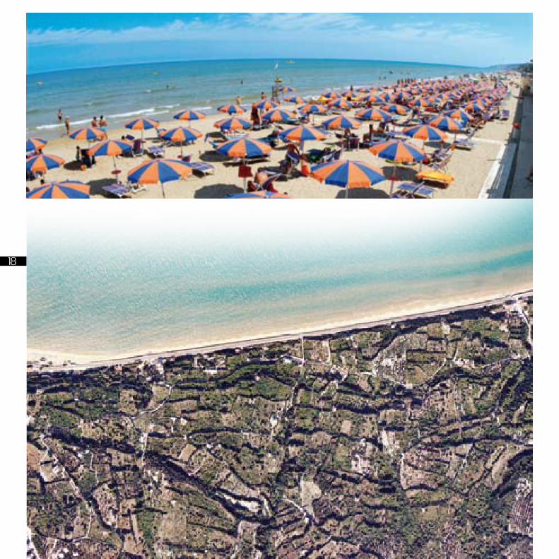
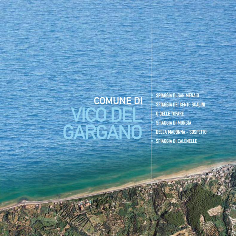
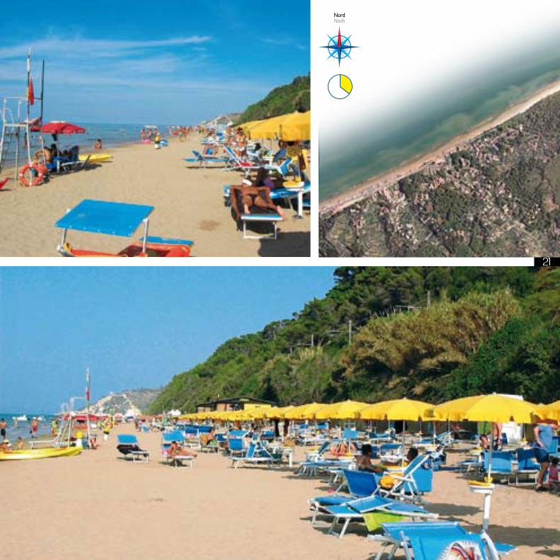
La spiaggia, prospiciente l’omoni-ma frazione di Vico del Gargano,
sviluppatasi intorno ad una antica torre e alle casette che ospitavano i contadini addetti nei profumatissimi e rinomati giardini, conta oggi numerosi e attrezzati lidi con annessi servizi che la rendono, nonostante l’estensione, ben attrezzata a soddisfare le più svariate esigenze. La località con la sua spiaggia ha contribuito in maniera rilevante allo sviluppo del turismo garganico, e già negli anni 50 annoverava svariati lidi attrezzati e residenze estive mentre nel resto del Gargano si viveva solo di agricoltura e pastorizia. La spiaggia confina a Nord , in località Pietre Nere, con il territorio di Rodi Garganico e su tutta la riviera giunge il fragore incantato degli aranceti che la circondano.
The beach faces the village of the same name, placed in the territory
of Vico del Gargano. It expanded round an ancient tower and the little houses, lived by the farmers cultivating the well-known and fragrant citrus trees. The large beach is equipped with a great number of good bathing establishments, that can meet the guests’ requirements. Since fifties, the village and its beach have heavily helped increasing tourism in the Gargano, that lived on agriculture and sheep-farming. The beach was equipped with bathing establishments and holiday-houses. On the North the beach borders, in Pietre Nere area, on Rodi Garganico, and is fragrant with its orange trees.
spiaggia di sAn menAIosan menaio beachcomune di (Town): VICO DEL GARGANOriferimento gPs (gPs): n. 41’56,070’ - e. 015’56,066’distanza fra i comuni vicini (distance from): rodi garganico km 4,7 - Peschici km 7,6
SAN MENAIO
21
CAPOIALE FOCE VARANO LIDO DEL SOLE SAN MENAIO PESCHICI BIVIO UMBRA MARE VIESTE TESTA DEL GARGANO PUGNOCHIUSO BIVIO SANTA TECLA BAIA DELLE ZAGARE MATTINATA km 0,0 km 5,61 km 10,6 km 12,47 km 23,35 km 30,85 km 47,53 km 53,93 km 62,33 km 72,59 km 77,49 km 87,02 km 102,47
CAGNANO VARANO ISCHITELLA RODI GARGANICO VICO DEL GARGANO PESCHICI VIESTE MATTINATA
NordNorth
22
CAPOIALE FOCE VARANO LIDO DEL SOLE SAN MENAIO PESCHICI BIVIO UMBRA MARE VIESTE TESTA DEL GARGANO PUGNOCHIUSO BIVIO SANTA TECLA BAIA DELLE ZAGARE MATTINATA km 0,0 km 5,61 km 10,6 km 12,47 km 23,35 km 30,85 km 47,53 km 53,93 km 62,33 km 72,59 km 77,49 km 87,02 km 102,47
CAGNANO VARANO ISCHITELLA RODI GARGANICO VICO DEL GARGANO PESCHICI VIESTE MATTINATA
970 18
NordNorth
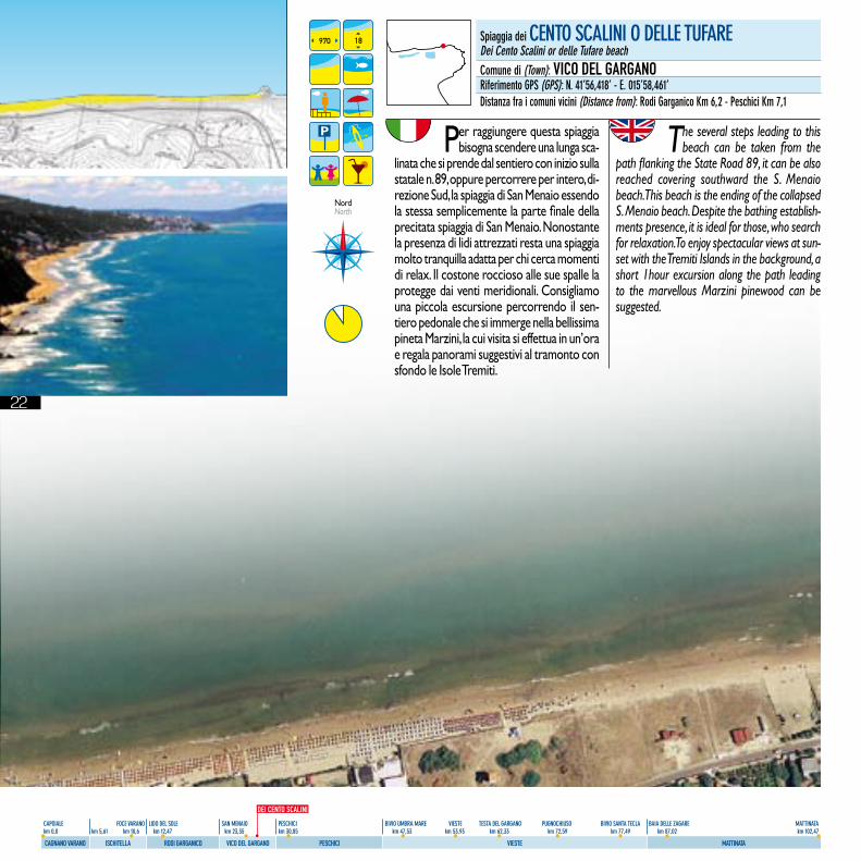
spiaggia dei cenTo scAlInI o delle TuFAre dei cento scalini or delle Tufare beachcomune di (Town): VICO DEL GARGANOriferimento gPs (gPs): n. 41’56,418’ - e. 015’58,461’distanza fra i comuni vicini (distance from): rodi garganico km 6,2 - Peschici km 7,1
DEI CENTO SCALINI
Per raggiungere questa spiaggia bisogna scendere una lunga sca-
linata che si prende dal sentiero con inizio sulla statale n. 89, oppure percorrere per intero, di-rezione Sud, la spiaggia di San Menaio essendo la stessa semplicemente la parte finale della precitata spiaggia di San Menaio. Nonostante la presenza di lidi attrezzati resta una spiaggia molto tranquilla adatta per chi cerca momenti di relax. Il costone roccioso alle sue spalle la protegge dai venti meridionali. Consigliamo una piccola escursione percorrendo il sen-tiero pedonale che si immerge nella bellissima pineta Marzini, la cui visita si effettua in un’ora e regala panorami suggestivi al tramonto con sfondo le Isole Tremiti.
The several steps leading to this beach can be taken from the
path flanking the State Road 89, it can be also reached covering southward the S. Menaio beach. This beach is the ending of the collapsed S. Menaio beach. Despite the bathing establish-ments presence, it is ideal for those, who search for relaxation. To enjoy spectacular views at sun-set with the Tremiti Islands in the background, a short 1hour excursion along the path leading to the marvellous Marzini pinewood can be suggested.
23
CAPOIALE FOCE VARANO LIDO DEL SOLE SAN MENAIO PESCHICI BIVIO UMBRA MARE VIESTE TESTA DEL GARGANO PUGNOCHIUSO BIVIO SANTA TECLA BAIA DELLE ZAGARE MATTINATA km 0,0 km 5,61 km 10,6 km 12,47 km 23,35 km 30,85 km 47,53 km 53,93 km 62,33 km 72,59 km 77,49 km 87,02 km 102,47
CAGNANO VARANO ISCHITELLA RODI GARGANICO VICO DEL GARGANO PESCHICI VIESTE MATTINATA
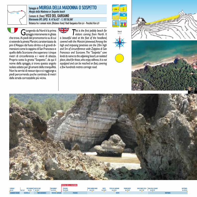
spiaggia di murgIA dellA mAdonnA o sosPeTTomurgia della madonna or sospetto beachcomune di (Town): VICO DEL GARGANOriferimento gPs (gPs): n. 41’56,427’ - e. 015’58,580’distanza fra i comuni vicini (distance from): rodi garganico km 6,4 - Peschici km 6,9
Giungendo da Nord è la prima spiaggia interamente in ghiaia
che trova. Ai piedi del promontorio su di cui si estende la pineta Marzini, caratterizzata da pini d’Aleppo dal fusto diritto e di grandi di-mensioni come lo zappino di San Francesco e quello dello Scorzone che superano i cinque metri di circonferenza e i venti di altezza. Proprio sotto la grotta “Sospetto”, da qui il nome della spiaggia, si trova questo angolo isolato adatto per gli amanti della tranquillità. Non ha servizi di nessun tipo e si raggiunge a piedi percorrendo poche centinaia di metri dalla strada carrozzabile più vicina.
This is the first pebbly beach for visitors coming from North. It
is beautiful sited at the foot of the headland, covered with the Marzini pinewood. Among the high and imposing pinetrees are the 20m high and 5m of circumference wide Zappino di San Francesco and Scorzone. The “Sospetto” cave lends its name to the adjoining beach, an isolated place, ideal for those, who enjoy stillness. It is not equipped and can be reached on foot, covering a few hundreds metres carriage road.
270 15
NordNorth
MURGIA DELLA MADONNA
24
CAPOIALE FOCE VARANO LIDO DEL SOLE SAN MENAIO PESCHICI BIVIO UMBRA MARE VIESTE TESTA DEL GARGANO PUGNOCHIUSO BIVIO SANTA TECLA BAIA DELLE ZAGARE MATTINATA km 0,0 km 5,61 km 10,6 km 12,47 km 23,35 km 30,85 km 47,53 km 53,93 km 62,33 km 72,59 km 77,49 km 87,02 km 102,47
CAGNANO VARANO ISCHITELLA RODI GARGANICO VICO DEL GARGANO PESCHICI VIESTE MATTINATA
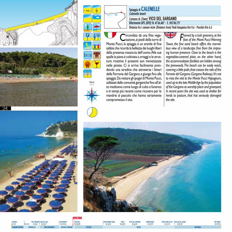
Circondata da una fitta vege-tazione, ai piedi della torre di
Monte Pucci, la spiaggia è un arenile di fine sabbia che ricorda la bellezza dei luoghi liberi dalla presenza massiccia dell’uomo. Alle sue spalle la piana è coltivata a ortaggi e le strut-ture ricettive li presenti son mimetizzate nelle pinete. Ci si arriva facilmente pren-dendo una stradina che attraversa i binari della Ferrovia del Gargano e giunge fino alla spiaggia. Da visitare gli ipogei di Monte Pucci, utilizzati dalle comunità garganiche fino all’al-to medioevo come luogo di culto e funereo e in tempi più recenti come ricovero per le mandrie al pascolo che hanno seriamente compromesso il sito.
Framed by a lush greenery, at the foot of the Monti Pucci Warning
Tower, the fine sand beach offers the marvel-lous view of a landscape free from the impos-ing human presence. Close to the beach is the vegetables-covered plain, on the other hand, the accommodation facilities are hidden among the pinewoods. The beach can be easily reach, covering a little path, that crosses the rails of the Ferrovie del Gargano (Gargano Railway). It’s not to miss the visit to the Monte Pucci Hypogeum, used up to the late Middle Age by the population of the Gargano as worship place and graveyard. In recent years the site was used as shelter for herds to pasture, that has seriously damaged the site.
spiaggia di cAlenellecalenelle beachcomune di (Town): VICO DEL GARGANOriferimento gPs (gPs): n. 41’56,487’ - e. 015’58,771’distanza fra i comuni vicini (distance from): rodi garganico km 9,6 - Peschici km 6,3
910 50
NordNorth
CALENELLE
25
CAPOIALE FOCE VARANO LIDO DEL SOLE SAN MENAIO PESCHICI BIVIO UMBRA MARE VIESTE TESTA DEL GARGANO PUGNOCHIUSO BIVIO SANTA TECLA BAIA DELLE ZAGARE MATTINATA km 0,0 km 5,61 km 10,6 km 12,47 km 23,35 km 30,85 km 47,53 km 53,93 km 62,33 km 72,59 km 77,49 km 87,02 km 102,47
CAGNANO VARANO ISCHITELLA RODI GARGANICO VICO DEL GARGANO PESCHICI VIESTE MATTINATA
comune di
PeScHici
• JALILLO O MAPPAMONDO
• MARINA DI PESCHICI
• LA CALA
• PROCINISCO
• SAN NICOLA
• ZAIANA
• MANACCORA
• CALA LUNGA
• BAIA DEL TURCO
• GUSMAY
• SPIAGGIA DELLA CROCE
O SANTA CROCE
• BESCILE O MANACORA
• SFINALE O SPINALE
26
CAPOIALE FOCE VARANO LIDO DEL SOLE SAN MENAIO PESCHICI BIVIO UMBRA MARE VIESTE TESTA DEL GARGANO PUGNOCHIUSO BIVIO SANTA TECLA BAIA DELLE ZAGARE MATTINATA km 0,0 km 5,61 km 10,6 km 12,47 km 23,35 km 30,85 km 47,53 km 53,93 km 62,33 km 72,59 km 77,49 km 87,02 km 102,47
CAGNANO VARANO ISCHITELLA RODI GARGANICO VICO DEL GARGANO PESCHICI VIESTE MATTINATA
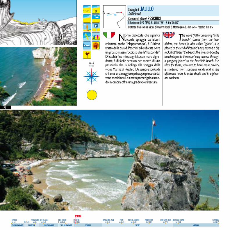
Nome dialettale che significa piccola spiaggia da alcuni
chiamata anche “Mappamondo”, è l’ultimo tratto della baia di Peschici ed è ubicata oltre un grosso masso roccioso che la “nasconde”. Di sabbia fine mista a ghiaia, con mare digra-dante, è di facile accesso per mezzo di una passerella che la collega alla spiaggia della vicina Marina di Peschici. Da sempre scelta da chi ama una maggiore privacy, è protetta dai venti meridionali e a metà pomeriggio essen-do in ombra offre una gradevole frescura.
The word “Jalillo”, meaning “little beach”, comes from the local
dialect, the beach is also called “globe”. It is placed at the end of Peschici’s bay, beyond a big rock, that “hides” the beach. The fine sand-pebbly beach slopes to the sea, of easy access through a gangway joined to the Peschici’s beach. It is ideal for those, who love to have more privacy, is sheltered from southern winds and in the afternoon hours is in the shade and in a pleas-ant coolness.
167 15
NordNorth
Spiaggia di JALILLOJalillo beachComune di (Town): PESCHICIRiferimento GPS (GPS): N. 41’56,726’ - E. 016’00,119’Distanza fra i comuni vicini (Distance from): S. Menaio (Vico G.) Km 6,45 - Peschici Km 1,5
JALILLO
27
CAPOIALE FOCE VARANO LIDO DEL SOLE SAN MENAIO PESCHICI BIVIO UMBRA MARE VIESTE TESTA DEL GARGANO PUGNOCHIUSO BIVIO SANTA TECLA BAIA DELLE ZAGARE MATTINATA km 0,0 km 5,61 km 10,6 km 12,47 km 23,35 km 30,85 km 47,53 km 53,93 km 62,33 km 72,59 km 77,49 km 87,02 km 102,47
CAGNANO VARANO ISCHITELLA RODI GARGANICO VICO DEL GARGANO PESCHICI VIESTE MATTINATA
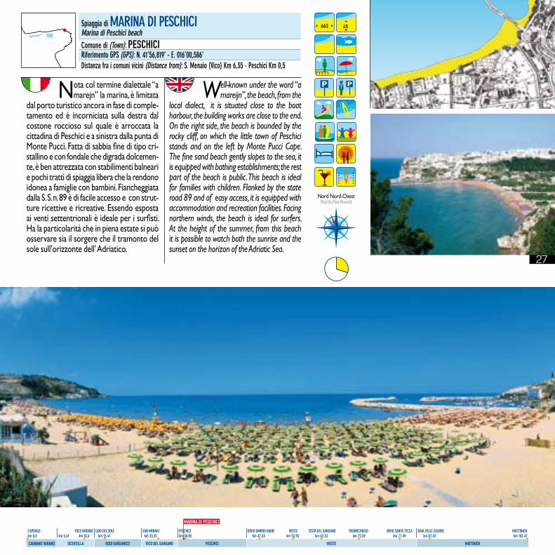
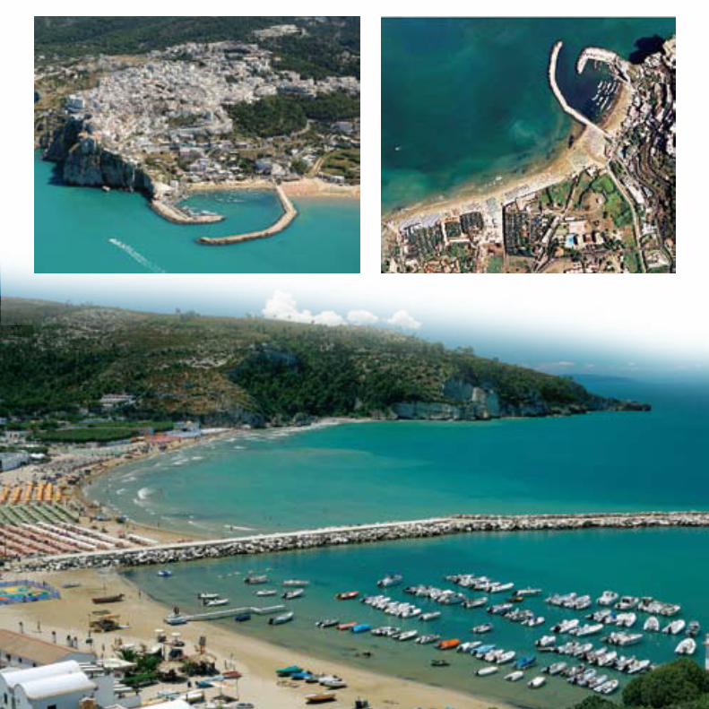
Nota col termine dialettale “a marejn” la marina, è limitata
dal porto turistico ancora in fase di comple-tamento ed è incorniciata sulla destra dal costone roccioso sul quale è arroccata la cittadina di Peschici e a sinistra dalla punta di Monte Pucci. Fatta di sabbia fine di tipo cri-stallino e con fondale che digrada dolcemen-te, è ben attrezzata con stabilimenti balneari e pochi tratti di spiaggia libera che la rendono idonea a famiglie con bambini. Fiancheggiata dalla S. S. n. 89 è di facile accesso e con strut-ture ricettive e ricreative. Essendo esposta ai venti settentrionali è ideale per i surfisti. Ha la particolarità che in piena estate si può osservare sia il sorgere che il tramonto del sole sull’orizzonte dell’ Adriatico.
Well-known under the word “a mareijn”, the beach, from the
local dialect, it is situated close to the boat harbour, the building works are close to the end. On the right side, the beach is bounded by the rocky cliff, on which the little town of Peschici stands and on the left by Monte Pucci Cape. The fine sand beach gently slopes to the sea, it is equipped with bathing establishments; the rest part of the beach is public. This beach is ideal for families with children. Flanked by the state road 89 and of easy access, it is equipped with accommodation and recreation facilities. Facing northern winds, the beach is ideal for surfers. At the height of the summer, from this beach it is possible to watch both the sunrise and the sunset on the horizon of the Adriatic Sea.
663 45
Nord Nord-OvestNorth-Northwest
Spiaggia di MARINA DI PESCHICIMarina di Peschici beachComune di (Town): PESCHICIRiferimento GPS (GPS): N. 41’56,819’ - E. 016’00,586’Distanza fra i comuni vicini (Distance from): S. Menaio (Vico) Km 6,35 - Peschici Km 0,5
MARINA DI PESCHICI
28
CAPOIALE FOCE VARANO LIDO DEL SOLE SAN MENAIO PESCHICI BIVIO UMBRA MARE VIESTE TESTA DEL GARGANO PUGNOCHIUSO BIVIO SANTA TECLA BAIA DELLE ZAGARE MATTINATA km 0,0 km 5,61 km 10,6 km 12,47 km 23,35 km 30,85 km 47,53 km 53,93 km 62,33 km 72,59 km 77,49 km 87,02 km 102,47
CAGNANO VARANO ISCHITELLA RODI GARGANICO VICO DEL GARGANO PESCHICI VIESTE MATTINATA
29
CAPOIALE FOCE VARANO LIDO DEL SOLE SAN MENAIO PESCHICI BIVIO UMBRA MARE VIESTE TESTA DEL GARGANO PUGNOCHIUSO BIVIO SANTA TECLA BAIA DELLE ZAGARE MATTINATA km 0,0 km 5,61 km 10,6 km 12,47 km 23,35 km 30,85 km 47,53 km 53,93 km 62,33 km 72,59 km 77,49 km 87,02 km 102,47
CAGNANO VARANO ISCHITELLA RODI GARGANICO VICO DEL GARGANO PESCHICI VIESTE MATTINATA
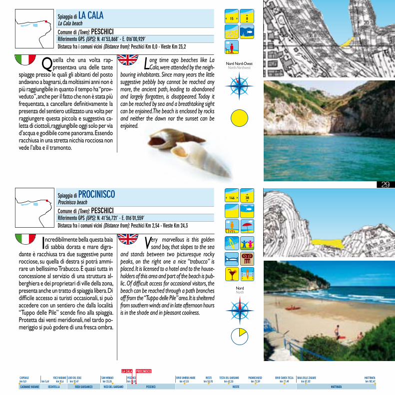
Quella che una volta rap-presentava una delle tante
spiagge presso le quali gli abitanti del posto andavano a bagnarsi, da moltissimi anni non è più raggiungibile in quanto il tempo ha “prov-veduto”, anche per il fatto che non è stata più frequentata, a cancellare definitivamente la presenza del sentiero utilizzato una volta per raggiungere questa piccola e suggestiva ca-letta di ciottoli, raggiungibile oggi solo per via d’acqua e godibile come panorama. Essendo racchiusa in una stretta nicchia rocciosa non vede l’alba e il tramonto.
Long time ago beaches like La Cala, were attended by the neigh-
bouring inhabitants. Since many years the little suggestive pebbly bay cannot be reached any more, the ancient path, leading to abandoned and largely forgotten, is disappeared. Today it can be reached by sea and a breathtaking sight can be enjoined. The beach is enclosed by rocks and neither the dawn nor the sunset can be enjoined.
15 8
Nord Nord-OvestNorth-Northwest
Spiaggia di PROCINISCOProcinisco beachComune di (Town): PESCHICIRiferimento GPS (GPS): N. 41’56,721’ - E. 016’01,559’Distanza fra i comuni vicini (Distance from): Peschici Km 2,54 - Vieste Km 24,3
Incredibilmente bella questa baia di sabbia dorata e mare digra-
dante è racchiusa tra due suggestive punte rocciose, su quella di destra si potrà ammi-rare un bellissimo Trabucco. È quasi tutta in concessione al servizio di una struttura al-berghiera e dei proprietari di ville della zona, presenta anche un tratto di spiaggia libera. Di difficile accesso ai turisti occasionali, si può accedere con un sentiero che dalla località “Tuppo delle Pile” scende fino alla spiaggia. Protetta dai venti meridionali, nel tardo po-meriggio si può godere di una fresca ombra.
Very marvellous is this golden sand bay, that slopes to the sea
and stands between two picturesque rocky peaks, on the right one a nice “trabucco” is placed. It is licensed to a hotel and to the house-holders of this area and part of the beach is pub-lic. Of difficult access for occasional visitors, the beach can be reached through a path branches off from the “Tuppo delle Pile” area. It is sheltered from southern winds and in late afternoon hours is in the shade and in pleasant coolness.
146 38
NordNorth
PROCINISCOLA CALA
Spiaggia di LA CALALa Cala beachComune di (Town): PESCHICIRiferimento GPS (GPS): N. 41’53,868’ - E. 016’00,929’Distanza fra i comuni vicini (Distance from): Peschici Km 0,0 - Vieste Km 23,2
30
CAPOIALE FOCE VARANO LIDO DEL SOLE SAN MENAIO PESCHICI BIVIO UMBRA MARE VIESTE TESTA DEL GARGANO PUGNOCHIUSO BIVIO SANTA TECLA BAIA DELLE ZAGARE MATTINATA km 0,0 km 5,61 km 10,6 km 12,47 km 23,35 km 30,85 km 47,53 km 53,93 km 62,33 km 72,59 km 77,49 km 87,02 km 102,47
CAGNANO VARANO ISCHITELLA RODI GARGANICO VICO DEL GARGANO PESCHICI VIESTE MATTINATA
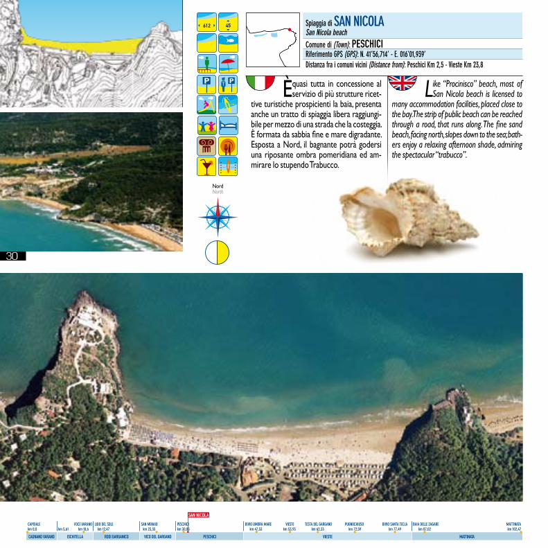
È quasi tutta in concessione al servizio di più strutture ricet-
tive turistiche prospicienti la baia, presenta anche un tratto di spiaggia libera raggiungi-bile per mezzo di una strada che la costeggia. È formata da sabbia fine e mare digradante. Esposta a Nord, il bagnante potrà godersi una riposante ombra pomeridiana ed am-mirare lo stupendo Trabucco.
Like “Procinisco” beach, most of San Nicola beach is licensed to
many accommodation facilities, placed close to the bay. The strip of public beach can be reached through a road, that runs along. The fine sand beach, facing north, slopes down to the sea; bath-ers enjoy a relaxing afternoon shade, admiring the spectacular “trabucco”.
612 45
NordNorth
Spiaggia di SAN NICOLASan Nicola beachComune di (Town): PESCHICIRiferimento GPS (GPS): N. 41’56,714’ - E. 016’01,939’Distanza fra i comuni vicini (Distance from): Peschici Km 2,5 - Vieste Km 23,8
SAN NICOLA
31
CAPOIALE FOCE VARANO LIDO DEL SOLE SAN MENAIO PESCHICI BIVIO UMBRA MARE VIESTE TESTA DEL GARGANO PUGNOCHIUSO BIVIO SANTA TECLA BAIA DELLE ZAGARE MATTINATA km 0,0 km 5,61 km 10,6 km 12,47 km 23,35 km 30,85 km 47,53 km 53,93 km 62,33 km 72,59 km 77,49 km 87,02 km 102,47
CAGNANO VARANO ISCHITELLA RODI GARGANICO VICO DEL GARGANO PESCHICI VIESTE MATTINATA
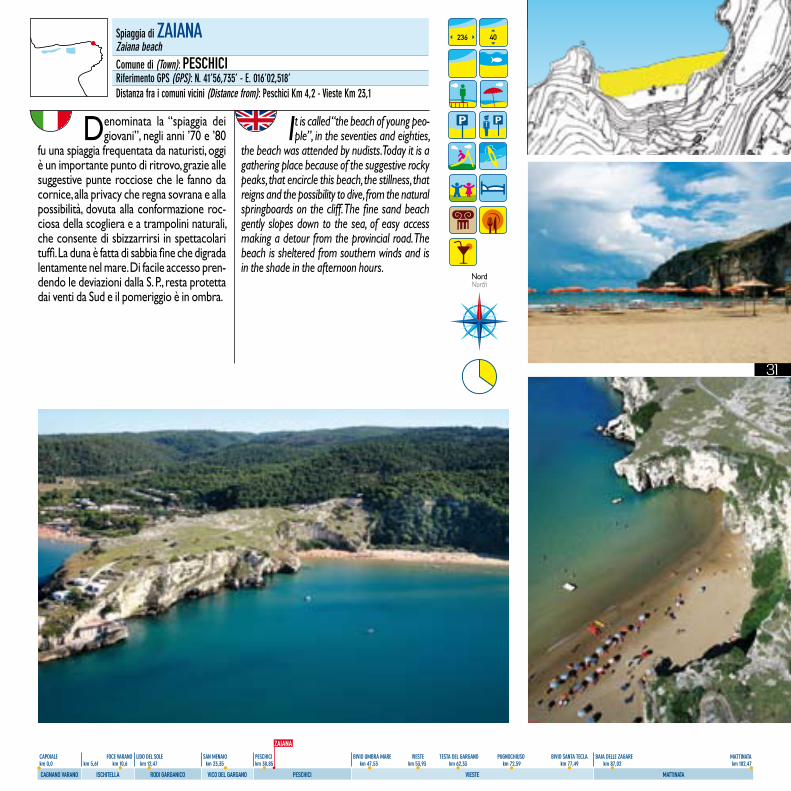
Denominata la “spiaggia dei giovani”, negli anni ’70 e ’80
fu una spiaggia frequentata da naturisti, oggi è un importante punto di ritrovo, grazie alle suggestive punte rocciose che le fanno da cornice, alla privacy che regna sovrana e alla possibilità, dovuta alla conformazione roc-ciosa della scogliera e a trampolini naturali, che consente di sbizzarrirsi in spettacolari tuffi. La duna è fatta di sabbia fine che digrada lentamente nel mare. Di facile accesso pren-dendo le deviazioni dalla S. P., resta protetta dai venti da Sud e il pomeriggio è in ombra.
It is called “the beach of young peo-ple”, in the seventies and eighties,
the beach was attended by nudists. Today it is a gathering place because of the suggestive rocky peaks, that encircle this beach, the stillness, that reigns and the possibility to dive, from the natural springboards on the cliff. The fine sand beach gently slopes down to the sea, of easy access making a detour from the provincial road. The beach is sheltered from southern winds and is in the shade in the afternoon hours.
236 40
Nord North
Spiaggia di ZAIANAZaiana beachComune di (Town): PESCHICIRiferimento GPS (GPS): N. 41’56,735’ - E. 016’02,518’Distanza fra i comuni vicini (Distance from): Peschici Km 4,2 - Vieste Km 23,1
ZAIANA
32
CAPOIALE FOCE VARANO LIDO DEL SOLE SAN MENAIO PESCHICI BIVIO UMBRA MARE VIESTE TESTA DEL GARGANO PUGNOCHIUSO BIVIO SANTA TECLA BAIA DELLE ZAGARE MATTINATA km 0,0 km 5,61 km 10,6 km 12,47 km 23,35 km 30,85 km 47,53 km 53,93 km 62,33 km 72,59 km 77,49 km 87,02 km 102,47
CAGNANO VARANO ISCHITELLA RODI GARGANICO VICO DEL GARGANO PESCHICI VIESTE MATTINATA
592 56
NordNorth
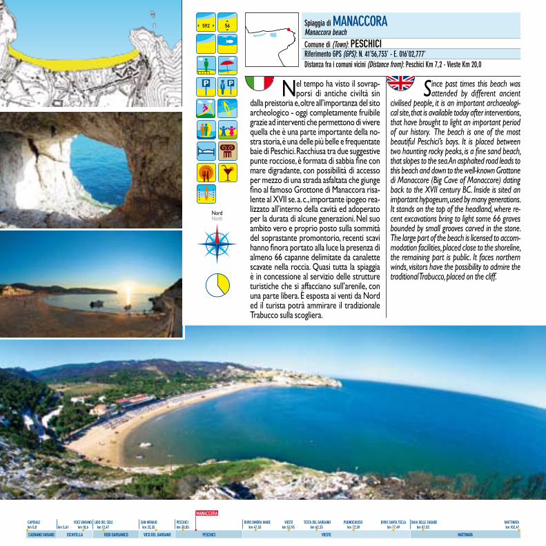
Nel tempo ha visto il sovrap-porsi di antiche civiltà sin
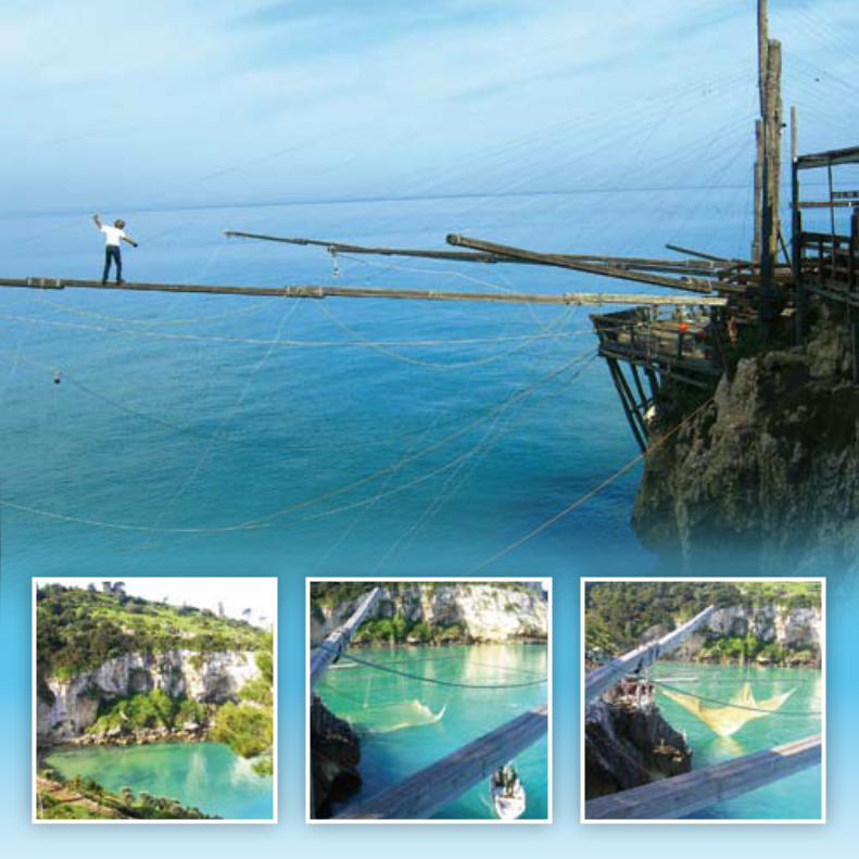
dalla preistoria e, oltre all’importanza del sito archeologico - oggi completamente fruibile grazie ad interventi che permettono di vivere quella che è una parte importante della no-stra storia, è una delle più belle e frequentate baie di Peschici. Racchiusa tra due suggestive punte rocciose, è formata di sabbia fine con mare digradante, con possibilità di accesso per mezzo di una strada asfaltata che giunge fino al famoso Grottone di Manaccora risa-lente al XVII se. a. c., importante ipogeo rea-lizzato all’interno della cavità ed adoperato per la durata di alcune generazioni. Nel suo ambito vero e proprio posto sulla sommità del soprastante promontorio, recenti scavi hanno finora portato alla luce la presenza di almeno 66 capanne delimitate da canalette scavate nella roccia. Quasi tutta la spiaggia è in concessione al servizio delle strutture turistiche che si affacciano sull’arenile, con una parte libera. È esposta ai venti da Nord ed il turista potrà ammirare il tradizionale Trabucco sulla scogliera.
Since past times this beach was attended by different ancient
civilised people, it is an important archaeologi-cal site, that is available today after interventions, that have brought to light an important period of our history. The beach is one of the most beautiful Peschici’s bays. It is placed between two haunting rocky peaks, is a fine sand beach, that slopes to the sea. An asphalted road leads to this beach and down to the well-known Grottone di Manaccore (Big Cave of Manaccore) dating back to the XVII century BC. Inside is sited an important hypogeum, used by many generations. It stands on the top of the headland, where re-cent excavations bring to light some 66 graves bounded by small grooves carved in the stone. The large part of the beach is licensed to accom-modation facilities, placed close to the shoreline, the remaining part is public. It faces northern winds, visitors have the possibility to admire the traditional Trabucco, placed on the cliff.
Spiaggia di MANACCORAManaccora beachComune di (Town): PESCHICIRiferimento GPS (GPS): N. 41’56,733’ - E. 016’02,777’Distanza fra i comuni vicini (Distance from): Peschici Km 7,2 - Vieste Km 20,0
MANACCORA
33
CAPOIALE FOCE VARANO LIDO DEL SOLE SAN MENAIO PESCHICI BIVIO UMBRA MARE VIESTE TESTA DEL GARGANO PUGNOCHIUSO BIVIO SANTA TECLA BAIA DELLE ZAGARE MATTINATA km 0,0 km 5,61 km 10,6 km 12,47 km 23,35 km 30,85 km 47,53 km 53,93 km 62,33 km 72,59 km 77,49 km 87,02 km 102,47
CAGNANO VARANO ISCHITELLA RODI GARGANICO VICO DEL GARGANO PESCHICI VIESTE MATTINATA
Spiaggia di CALA LUNGACala Lunga beachComune di (Town): PESCHICIRiferimento GPS (GPS): N. 41’56,684’ - E. 016’03,408’Distanza fra i comuni vicini (Distance from): Peschici Km 7,74 - Vieste Km 15,8
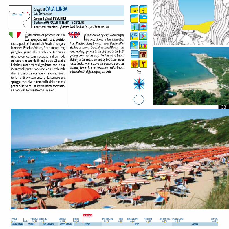
Èdelimitata da promontori che si spingono nel mare, posizio-
nata a pochi chilometri da Peschici, lungo la litoranea Peschici/Vieste, è facilmente rag-giungibile grazie alla strada che termina a ridosso del costone roccioso e al comodo sentiero che scende fin nella baia. Di sabbia finissima e con mare digradante, con le due incantevoli punte rocciose, con i trabucchi che le fanno da cornice e la onnipresen-te Torre di avvistamento, è da sempre una spiaggia esclusiva e tranquilla dalla quale si potrà osservare una interessante formazio-ne rocciosa terminate con un arco.
It is encircled by cliffs overhanging the sea, placed a few kilometres
from Peschici along the coast road Peschici/Vie-ste. The beach can be easily reached through the road leading up close to the cliff and to the path getting down to the bay. The fine sand beach, sloping to the sea, is framed by two picturesque rocky peaks, where stand the trabucchi and the warning tower. It is an exclusive restful beach, adorned with cliffs, shaping an arch.
182 40
NordNorth
CALA LUNGA
34
CAPOIALE FOCE VARANO LIDO DEL SOLE SAN MENAIO PESCHICI BIVIO UMBRA MARE VIESTE TESTA DEL GARGANO PUGNOCHIUSO BIVIO SANTA TECLA BAIA DELLE ZAGARE MATTINATA km 0,0 km 5,61 km 10,6 km 12,47 km 23,35 km 30,85 km 47,53 km 53,93 km 62,33 km 72,59 km 77,49 km 87,02 km 102,47
CAGNANO VARANO ISCHITELLA RODI GARGANICO VICO DEL GARGANO PESCHICI VIESTE MATTINATA
Ubicata tra la baia del Gusmay e la spiaggia di “Bescile” è una
delle baie - anche se piccola - meno affol-late e godibilissima di Peschici; di sabbia e mare che digrada dolcemente, facilmente raggiungibile per mezzo di una stradina che lambisce la baietta, proseguendo, poi, per un comodo sentiero. Esposta a Nord è riparata dai venti meridionali.
It stands between the Gusmay bay and the “Bescile” beach, is one of
the most fascinating and less crowded small Peschici’s beaches. The sand beach gently slopes to the sea and can be easily reached through a little road, that runs along the small bay and leads to a path. It faces north and is sheltered from southern winds.
10 5
Nord Nord-Est North-Northeast
Spiaggia di CALA DEL TURCOCala del Turco beachComune di (Town): PESCHICIRiferimento GPS (GPS): N. 41’56,717’ - E. 016’03,715’Distanza fra i comuni vicini (Distance from): Peschici Km 7,55 - Vieste Km 15,61
Spiaggia della CROCE O SANTA CROCEDella Croce or Santa Croce beachComune di (Town): PESCHICIRiferimento GPS (GPS): N. 41’56,555’ - E. 016’04,132’Distanza fra i comuni vicini (Distance from): Peschici Km 8,85 - Vieste Km 15,05
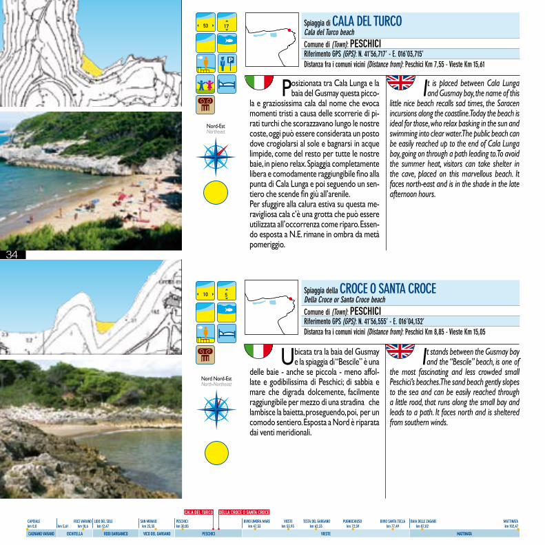
Posizionata tra Cala Lunga e la baia del Gusmay questa picco-
la e graziosissima cala dal nome che evoca momenti tristi a causa delle scorrerie di pi-rati turchi che scorazzavano lungo le nostre coste, oggi può essere considerata un posto dove crogiolarsi al sole e bagnarsi in acque limpide, come del resto per tutte le nostre baie, in pieno relax. Spiaggia completamente libera e comodamente raggiungibile fino alla punta di Cala Lunga e poi seguendo un sen-tiero che scende fin giù all’arenile.Per sfuggire alla calura estiva su questa me-ravigliosa cala c’è una grotta che può essere utilizzata all’occorrenza come riparo. Essen-do esposta a N.E. rimane in ombra da metà pomeriggio.
It is placed between Cala Lunga and Gusmay bay, the name of this
little nice beach recalls sad times, the Saracen incursions along the coastline. Today the beach is ideal for those, who relax basking in the sun and swimming into clear water. The public beach can be easily reached up to the end of Cala Lunga bay, going on through a path leading to. To avoid the summer heat, visitors can take shelter in the cave, placed on this marvellous beach. It faces north-east and is in the shade in the late afternoon hours.
53 17
Nord-EstNortheast
CALA DEL TURCO DELLA CROCE O SANTA CROCE
35
CAPOIALE FOCE VARANO LIDO DEL SOLE SAN MENAIO PESCHICI BIVIO UMBRA MARE VIESTE TESTA DEL GARGANO PUGNOCHIUSO BIVIO SANTA TECLA BAIA DELLE ZAGARE MATTINATA km 0,0 km 5,61 km 10,6 km 12,47 km 23,35 km 30,85 km 47,53 km 53,93 km 62,33 km 72,59 km 77,49 km 87,02 km 102,47
CAGNANO VARANO ISCHITELLA RODI GARGANICO VICO DEL GARGANO PESCHICI VIESTE MATTINATA
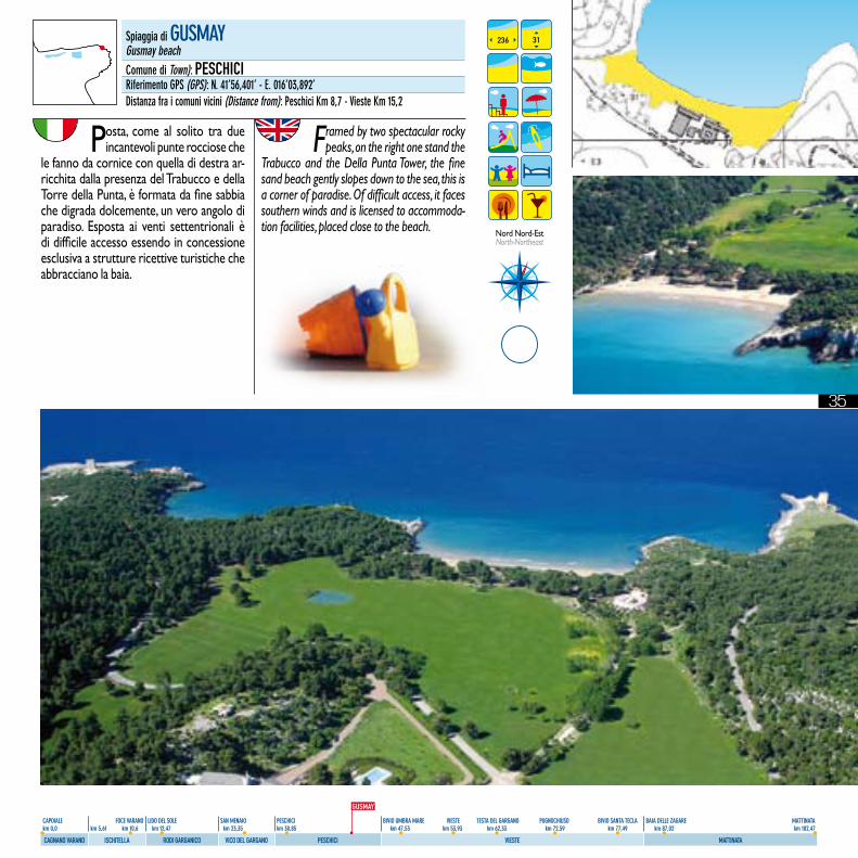
Posta, come al solito tra due incantevoli punte rocciose che
le fanno da cornice con quella di destra ar-ricchita dalla presenza del Trabucco e della Torre della Punta, è formata da fine sabbia che digrada dolcemente, un vero angolo di paradiso. Esposta ai venti settentrionali è di difficile accesso essendo in concessione esclusiva a strutture ricettive turistiche che abbracciano la baia.
Framed by two spectacular rocky peaks, on the right one stand the
Trabucco and the Della Punta Tower, the fine sand beach gently slopes down to the sea, this is a corner of paradise. Of difficult access, it faces southern winds and is licensed to accommoda-tion facilities, placed close to the beach.
236 31
Nord Nord-EstNorth-Northeast
Spiaggia di GUSMAYGusmay beachComune di Town): PESCHICIRiferimento GPS (GPS): N. 41’56,401’ - E. 016’03,892’Distanza fra i comuni vicini (Distance from): Peschici Km 8,7 - Vieste Km 15,2
GUSMAY
36
CAPOIALE FOCE VARANO LIDO DEL SOLE SAN MENAIO PESCHICI BIVIO UMBRA MARE VIESTE TESTA DEL GARGANO PUGNOCHIUSO BIVIO SANTA TECLA BAIA DELLE ZAGARE MATTINATA km 0,0 km 5,61 km 10,6 km 12,47 km 23,35 km 30,85 km 47,53 km 53,93 km 62,33 km 72,59 km 77,49 km 87,02 km 102,47
CAGNANO VARANO ISCHITELLA RODI GARGANICO VICO DEL GARGANO PESCHICI VIESTE MATTINATA
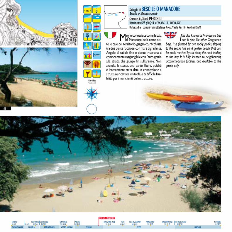
Meglio conosciuta come la baia di Manacore, bella come tut-
te le baie del territorio garganico, racchiusa tra due punte rocciose, con mare digradante. Angolo di sabbia fine e dorata riservata e comodamente raggiungibile con l’auto grazie alla strada che giunge fin sull’arenile. Non avendo, la stessa, una parte libera, poiché è interamente stata data in concessione a strutture ricettive limitrofe, è di difficile frui-bilità per i non clienti delle strutture.
It is also known as Manaccore bay and is nice like other Gargnano’s
bays. It is framed by two rocky peaks, sloping to the sea. A fine sand golden beach, that can be easily reached by car along the road leading to the bay. It is fully licensed to neighbouring accommodation facilities and available to the guests only.
417 36
Nord-EstNortheast
Spiaggia di BESCILE O MANACOREBescile or Manacore beachComune di (Town): PESCHICIRiferimento GPS (GPS): N. 41’56,434’ - E. 016’04,520’Distanza fra i comuni vicini (Distance from): Vieste Km 13 - Peschici Km 11
BESCILE - MANACORE
37
CAPOIALE FOCE VARANO LIDO DEL SOLE SAN MENAIO PESCHICI BIVIO UMBRA MARE VIESTE TESTA DEL GARGANO PUGNOCHIUSO BIVIO SANTA TECLA BAIA DELLE ZAGARE MATTINATA km 0,0 km 5,61 km 10,6 km 12,47 km 23,35 km 30,85 km 47,53 km 53,93 km 62,33 km 72,59 km 77,49 km 87,02 km 102,47
CAGNANO VARANO ISCHITELLA RODI GARGANICO VICO DEL GARGANO PESCHICI VIESTE MATTINATA
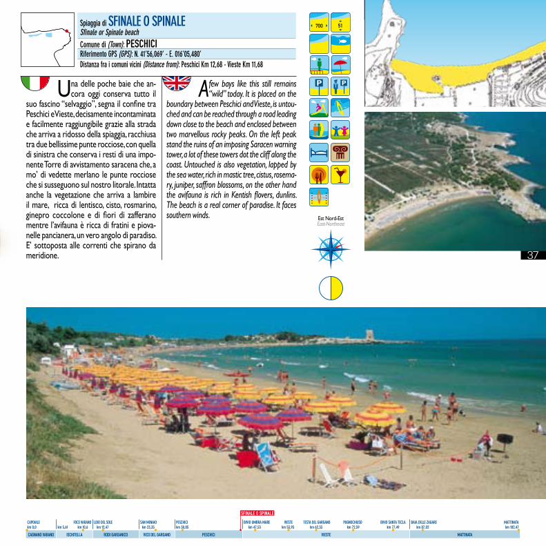
Una delle poche baie che an-cora oggi conserva tutto il
suo fascino “selvaggio”, segna il confine tra Peschici e Vieste, decisamente incontaminata e facilmente raggiungibile grazie alla strada che arriva a ridosso della spiaggia, racchiusa tra due bellissime punte rocciose, con quella di sinistra che conserva i resti di una impo-nente Torre di avvistamento saracena che, a mo’ di vedette merlano le punte rocciose che si susseguono sul nostro litorale. Intatta anche la vegetazione che arriva a lambire il mare, ricca di lentisco, cisto, rosmarino, ginepro coccolone e di fiori di zafferano mentre l’avifauna è ricca di fratini e piova-nelle pancianera, un vero angolo di paradiso. E’ sottoposta alle correnti che spirano da meridione.
A few bays like this still remains “wild” today. It is placed on the
boundary between Peschici and Vieste, is untou-ched and can be reached through a road leading down close to the beach and enclosed between two marvellous rocky peaks. On the left peak stand the ruins of an imposing Saracen warning tower, a lot of these towers dot the cliff along the coast. Untouched is also vegetation, lapped by the sea water, rich in mastic tree, cistus, rosema-ry, juniper, saffron blossoms, on the other hand the avifauna is rich in Kentish flovers, dunlins. The beach is a real corner of paradise. It faces southern winds.
700 51
Est Nord-Est East-Northeast
Spiaggia di SFINALE O SPINALESfinale or Spinale beachComune di (Town): PESCHICIRiferimento GPS (GPS): N. 41’56,069’ - E. 016’05,480’Distanza fra i comuni vicini (Distance from): Peschici Km 12,68 - Vieste Km 11,68
SFINALE O SPINALE
39
CAPOIALE FOCE VARANO LIDO DEL SOLE SAN MENAIO PESCHICI BIVIO UMBRA MARE VIESTE TESTA DEL GARGANO PUGNOCHIUSO BIVIO SANTA TECLA BAIA DELLE ZAGARE MATTINATA km 0,0 km 5,61 km 10,6 km 12,47 km 23,35 km 30,85 km 47,53 km 53,93 km 62,33 km 72,59 km 77,49 km 87,02 km 102,47
CAGNANO VARANO ISCHITELLA RODI GARGANICO VICO DEL GARGANO PESCHICI VIESTE MATTINATA
comune di
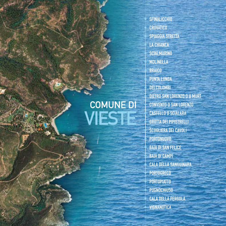
VieSTe
• SFINALICCHIO
• CROVATICO
• SPIAGGIA STRETTA
• LA CHIANCA
• SCIALMARINO
• MOLINELLA
• BRAICO
• PUNTA LUNGA
• DEI COLOMBI
• DIETRO SAN LORENZO O U MURT
• CONVENTO O SAN LORENZO
• CASTELLO O SCIALARA
• GROTTA DEI PIPISTRELLI
• SCOGLIERA DEI CAVOLI
• PORTONUOVO
• BAIA DI SAN FELICE
• BAIA DI CAMPI
• CALA DELLA SANGUINARA
• PORTOGRECO
• PORTOPIATTO
• PUGNOCHIUSO
• CALA DELLA PERGOLA
• VIGNANOTICA
40
CAPOIALE FOCE VARANO LIDO DEL SOLE SAN MENAIO PESCHICI BIVIO UMBRA MARE VIESTE TESTA DEL GARGANO PUGNOCHIUSO BIVIO SANTA TECLA BAIA DELLE ZAGARE MATTINATA km 0,0 km 5,61 km 10,6 km 12,47 km 23,35 km 30,85 km 47,53 km 53,93 km 62,33 km 72,59 km 77,49 km 87,02 km 102,47
CAGNANO VARANO ISCHITELLA RODI GARGANICO VICO DEL GARGANO PESCHICI VIESTE MATTINATA
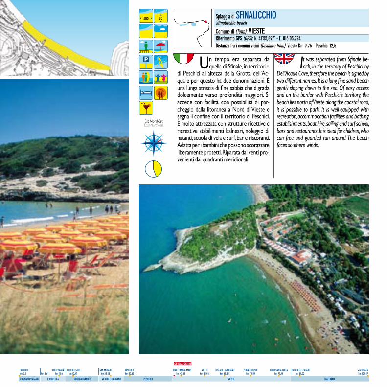
Un tempo era separata da quella di Sfinale, in territorio
di Peschici all’altezza della Grotta dell’Ac-qua e per questo ha due denominazioni. È una lunga striscia di fine sabbia che digrada dolcemente verso profondità maggiori. Si accede con facilità, con possibilità di par-cheggio dalla litoranea a Nord di Vieste e segna il confine con il territorio di Peschici. È molto attrezzata con strutture ricettive e ricreative stabilimenti balneari, noleggio di natanti, scuola di vela e surf, bar e ristoranti. Adatta per i bambini che possono scorazzare liberamente protetti. Riparata dai venti pro-venienti dai quadranti meridionali.
It was separated from Sfinale be-ach, in the territory of Peschici by
Dell’Acqua Cave, therefore the beach is signed by two different names. It is a long fine sand beach gently sloping down to the sea. Of easy access and on the border with Peschici’s territory, the beach lies north of Vieste along the coastal road, it is possible to park. It is well-equipped with recreation, accommodation facilities and bathing establishments, boat hire, sailing and surf school, bars and restaurants. It is ideal for children, who can free and guarded run around. The beach faces southern winds.
450 30
Est Nord-Est East-Northeast
Spiaggia di SFINALICCHIOSfinalicchio beachComune di (Town): VIESTERiferimento GPS (GPS): N. 41’55,897’ - E. 016’05,724’Distanza fra i comuni vicini (Distance from): Vieste Km 9,75 - Peschici 12,5
SFINALICCHIO
41
CAPOIALE FOCE VARANO LIDO DEL SOLE SAN MENAIO PESCHICI BIVIO UMBRA MARE VIESTE TESTA DEL GARGANO PUGNOCHIUSO BIVIO SANTA TECLA BAIA DELLE ZAGARE MATTINATA km 0,0 km 5,61 km 10,6 km 12,47 km 23,35 km 30,85 km 47,53 km 53,93 km 62,33 km 72,59 km 77,49 km 87,02 km 102,47
CAGNANO VARANO ISCHITELLA RODI GARGANICO VICO DEL GARGANO PESCHICI VIESTE MATTINATA
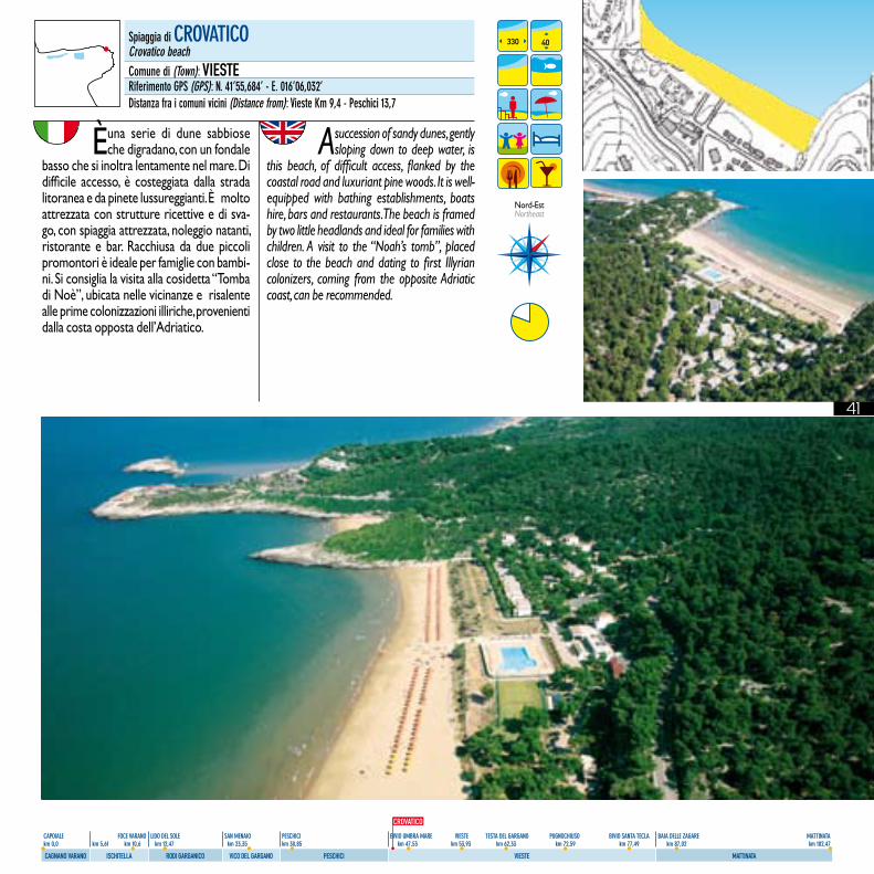
È una serie di dune sabbiose che digradano, con un fondale
basso che si inoltra lentamente nel mare. Di difficile accesso, è costeggiata dalla strada litoranea e da pinete lussureggianti. È molto attrezzata con strutture ricettive e di sva-go, con spiaggia attrezzata, noleggio natanti, ristorante e bar. Racchiusa da due piccoli promontori è ideale per famiglie con bambi-ni. Si consiglia la visita alla cosidetta “Tomba di Noè”, ubicata nelle vicinanze e risalente alle prime colonizzazioni illiriche, provenienti dalla costa opposta dell’Adriatico.
A succession of sandy dunes, gently sloping down to deep water, is
this beach, of difficult access, flanked by the coastal road and luxuriant pine woods. It is well-equipped with bathing establishments, boats hire, bars and restaurants. The beach is framed by two little headlands and ideal for families with children. A visit to the “Noah’s tomb”, placed close to the beach and dating to first Illyrian colonizers, coming from the opposite Adriatic coast, can be recommended.
330 40
Nord-EstNortheast
Spiaggia di CROVATICOCrovatico beachComune di (Town): VIESTERiferimento GPS (GPS): N. 41’55,684’ - E. 016’06,032’Distanza fra i comuni vicini (Distance from): Vieste Km 9,4 - Peschici 13,7
CROVATICO
42
CAPOIALE FOCE VARANO LIDO DEL SOLE SAN MENAIO PESCHICI BIVIO UMBRA MARE VIESTE TESTA DEL GARGANO PUGNOCHIUSO BIVIO SANTA TECLA BAIA DELLE ZAGARE MATTINATA km 0,0 km 5,61 km 10,6 km 12,47 km 23,35 km 30,85 km 47,53 km 53,93 km 62,33 km 72,59 km 77,49 km 87,02 km 102,47
CAGNANO VARANO ISCHITELLA RODI GARGANICO VICO DEL GARGANO PESCHICI VIESTE MATTINATA
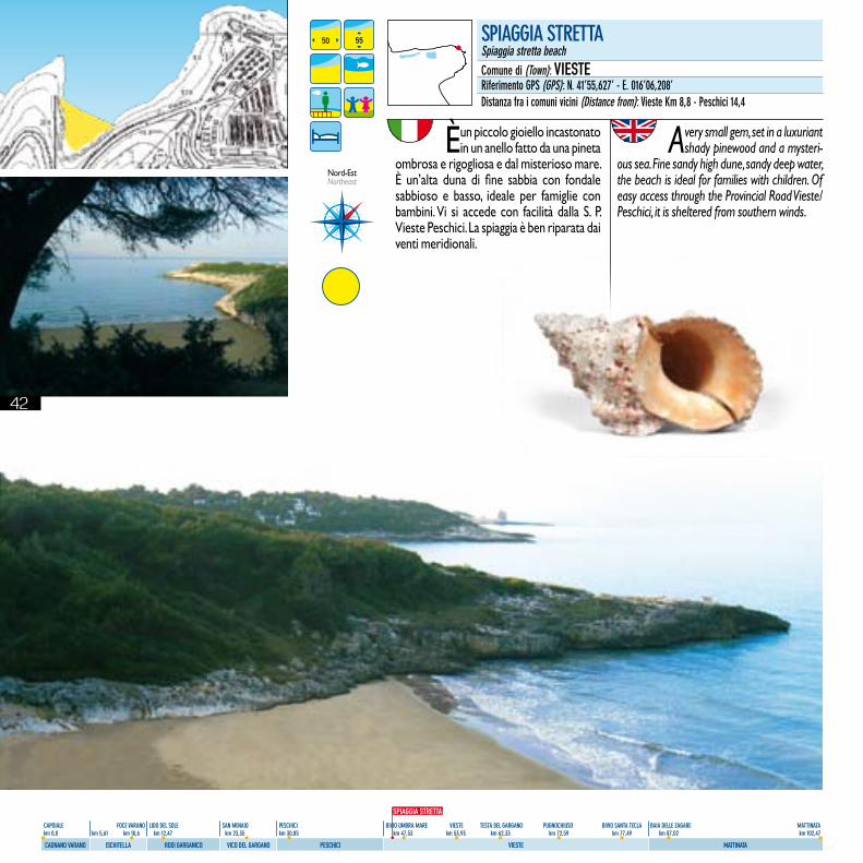
È un piccolo gioiello incastonato in un anello fatto da una pineta
ombrosa e rigogliosa e dal misterioso mare. È un’alta duna di fine sabbia con fondale sabbioso e basso, ideale per famiglie con bambini. Vi si accede con facilità dalla S. P. Vieste Peschici. La spiaggia è ben riparata dai venti meridionali.
A very small gem, set in a luxuriant shady pinewood and a mysteri-
ous sea. Fine sandy high dune, sandy deep water, the beach is ideal for families with children. Of easy access through the Provincial Road Vieste/Peschici, it is sheltered from southern winds.
50 55
Nord-EstNortheast
SPIAGGIA STRETTASpiaggia stretta beachComune di (Town): VIESTERiferimento GPS (GPS): N. 41’55,627’ - E. 016’06,208’Distanza fra i comuni vicini (Distance from): Vieste Km 8,8 - Peschici 14,4
SPIAGGIA STRETTA
43
CAPOIALE FOCE VARANO LIDO DEL SOLE SAN MENAIO PESCHICI BIVIO UMBRA MARE VIESTE TESTA DEL GARGANO PUGNOCHIUSO BIVIO SANTA TECLA BAIA DELLE ZAGARE MATTINATA km 0,0 km 5,61 km 10,6 km 12,47 km 23,35 km 30,85 km 47,53 km 53,93 km 62,33 km 72,59 km 77,49 km 87,02 km 102,47
CAGNANO VARANO ISCHITELLA RODI GARGANICO VICO DEL GARGANO PESCHICI VIESTE MATTINATA
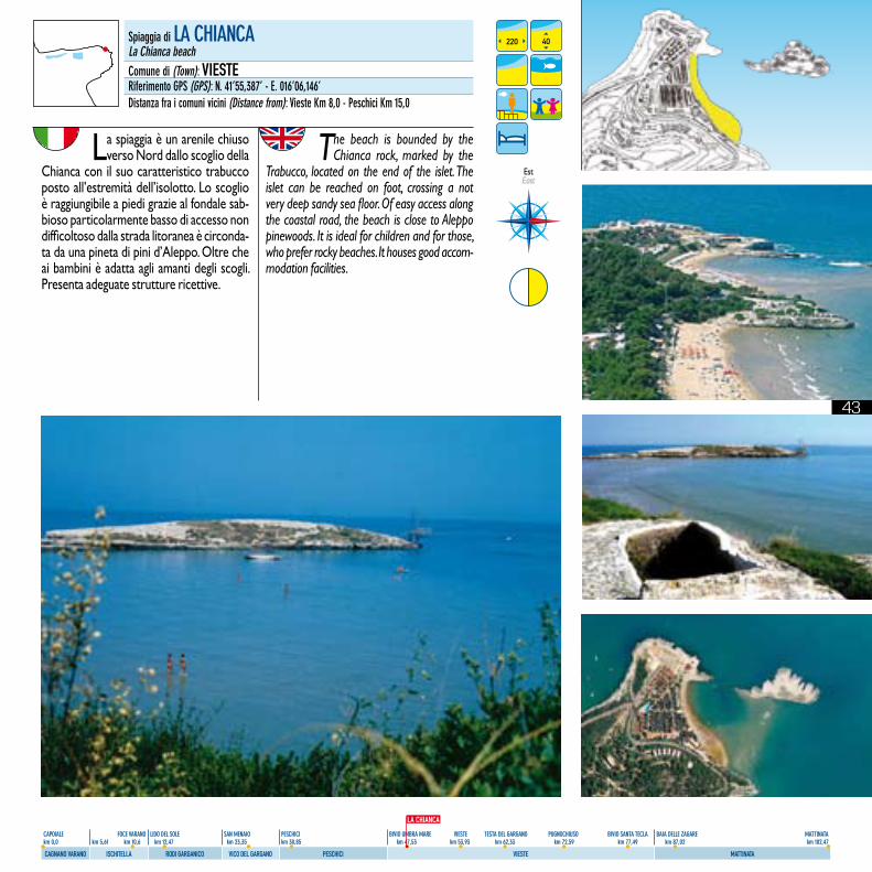
La spiaggia è un arenile chiuso verso Nord dallo scoglio della
Chianca con il suo caratteristico trabucco posto all’estremità dell’isolotto. Lo scoglio è raggiungibile a piedi grazie al fondale sab-bioso particolarmente basso di accesso non difficoltoso dalla strada litoranea è circonda-ta da una pineta di pini d’Aleppo. Oltre che ai bambini è adatta agli amanti degli scogli. Presenta adeguate strutture ricettive.
The beach is bounded by the Chianca rock, marked by the
Trabucco, located on the end of the islet. The islet can be reached on foot, crossing a not very deep sandy sea floor. Of easy access along the coastal road, the beach is close to Aleppo pinewoods. It is ideal for children and for those, who prefer rocky beaches. It houses good accom-modation facilities.
220 40
EstEast
Spiaggia di LA CHIANCALa Chianca beachComune di (Town): VIESTERiferimento GPS (GPS): N. 41’55,387’ - E. 016’06,146’Distanza fra i comuni vicini (Distance from): Vieste Km 8,0 - Peschici Km 15,0
LA CHIANCA
44
CAPOIALE FOCE VARANO LIDO DEL SOLE SAN MENAIO PESCHICI BIVIO UMBRA MARE VIESTE TESTA DEL GARGANO PUGNOCHIUSO BIVIO SANTA TECLA BAIA DELLE ZAGARE MATTINATA km 0,0 km 5,61 km 10,6 km 12,47 km 23,35 km 30,85 km 47,53 km 53,93 km 62,33 km 72,59 km 77,49 km 87,02 km 102,47
CAGNANO VARANO ISCHITELLA RODI GARGANICO VICO DEL GARGANO PESCHICI VIESTE MATTINATA
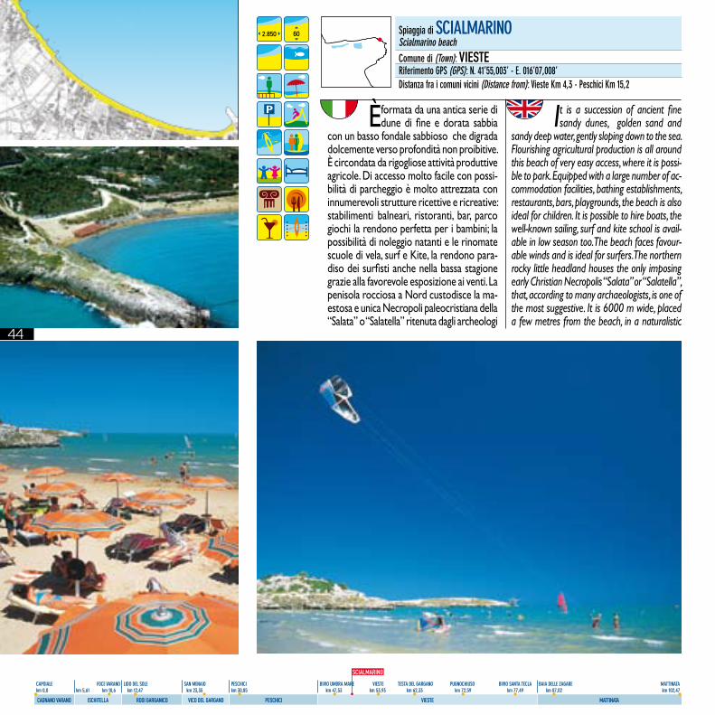
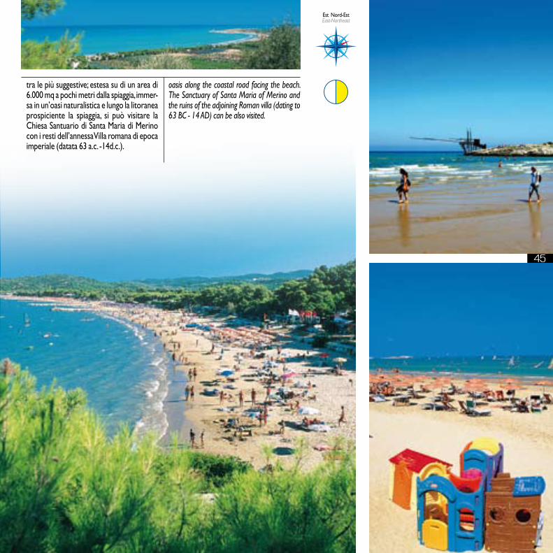
È formata da una antica serie di dune di fine e dorata sabbia
con un basso fondale sabbioso che digrada dolcemente verso profondità non proibitive. È circondata da rigogliose attività produttive agricole. Di accesso molto facile con possi-bilità di parcheggio è molto attrezzata con innumerevoli strutture ricettive e ricreative: stabilimenti balneari, ristoranti, bar, parco giochi la rendono perfetta per i bambini; la possibilità di noleggio natanti e le rinomate scuole di vela, surf e Kite, la rendono para-diso dei surfisti anche nella bassa stagione grazie alla favorevole esposizione ai venti. La penisola rocciosa a Nord custodisce la ma-estosa e unica Necropoli paleocristiana della “Salata” o “Salatella” ritenuta dagli archeologi
It is a succession of ancient fine sandy dunes, golden sand and
sandy deep water, gently sloping down to the sea. Flourishing agricultural production is all around this beach of very easy access, where it is possi-ble to park. Equipped with a large number of ac-commodation facilities, bathing establishments, restaurants, bars, playgrounds, the beach is also ideal for children. It is possible to hire boats, the well-known sailing, surf and kite school is avail-able in low season too. The beach faces favour-able winds and is ideal for surfers. The northern rocky little headland houses the only imposing early Christian Necropolis “Salata” or “Salatella”, that, according to many archaeologists, is one of the most suggestive. It is 6000 m wide, placed a few metres from the beach, in a naturalistic
2.850 60 Spiaggia di SCIALMARINOScialmarino beachComune di (Town): VIESTERiferimento GPS (GPS): N. 41’55,003’ - E. 016’07,008’Distanza fra i comuni vicini (Distance from): Vieste Km 4,3 - Peschici Km 15,2
SCIALMARINO
4545
oasis along the coastal road facing the beach. The Sanctuary of Santa Maria of Merino and the ruins of the adjoining Roman villa (dating to 63 BC - 14 AD) can be also visited.
Est Nord-Est East-Northeast
tra le più suggestive; estesa su di un area di 6.000 mq a pochi metri dalla spiaggia, immer-sa in un’oasi naturalistica e lungo la litoranea prospiciente la spiaggia, si può visitare la Chiesa Santuario di Santa Maria di Merino con i resti dell’annessa Villa romana di epoca imperiale (datata 63 a.c. -14d.c.).
46
CAPOIALE FOCE VARANO LIDO DEL SOLE SAN MENAIO PESCHICI BIVIO UMBRA MARE VIESTE TESTA DEL GARGANO PUGNOCHIUSO BIVIO SANTA TECLA BAIA DELLE ZAGARE MATTINATA km 0,0 km 5,61 km 10,6 km 12,47 km 23,35 km 30,85 km 47,53 km 53,93 km 62,33 km 72,59 km 77,49 km 87,02 km 102,47
CAGNANO VARANO ISCHITELLA RODI GARGANICO VICO DEL GARGANO PESCHICI VIESTE MATTINATA
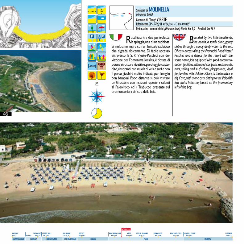
Racchiusa tra due penisolette, la spiaggia, una duna sabbiosa,
si inoltra nel mare con un fondale sabbioso che digrada dolcemente. Di facile accesso attraverso la S. P. Vieste-Peschici con de-viazione per l’omonima località, è dotata di buone strutture ricettive, parcheggio custo-dito, ristoranti, bar, scuola di vela e surf e con il parco giochi è molto indicata per famiglie con bambini. Poco distante si può visitare un Grottone con incisioni rupestri risalenti al Paleolitico ed il Trabucco presente sul promontorio, a sinistra della baia.
Bounded by two little headlands, the beach, a sandy dune, gently
slopes through a sandy deep water to the sea. Of easy access along the Provincial Road Vieste/Peschici and a detour for the resort with the same name, it is equipped with good accommo-dation facilities, attended car park, restaurants, bars, sailing and surf school, playgrounds, ideal for families with children. Close to the beach is a big Cave, with stone cuts, dating to the Paleolith Era and a Trabucco, placed on the promontory left of the bay.
380 50
Est East
Spiaggia di MOLINELLAMolinella beachComune di (Town): VIESTERiferimento GPS (GPS): N. 41’54,314’ - E. 016’09,033’Distanza fra i comuni vicini (Distance from): Vieste Km 3,2 - Peschici Km 21,2
MOLINELLA
47
CAPOIALE FOCE VARANO LIDO DEL SOLE SAN MENAIO PESCHICI BIVIO UMBRA MARE VIESTE TESTA DEL GARGANO PUGNOCHIUSO BIVIO SANTA TECLA BAIA DELLE ZAGARE MATTINATA km 0,0 km 5,61 km 10,6 km 12,47 km 23,35 km 30,85 km 47,53 km 53,93 km 62,33 km 72,59 km 77,49 km 87,02 km 102,47
CAGNANO VARANO ISCHITELLA RODI GARGANICO VICO DEL GARGANO PESCHICI VIESTE MATTINATA
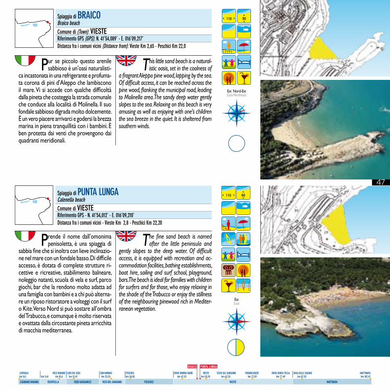
Prende il nome dall’omonima penisoletta, è una spiaggia di
sabbia fine che si inoltra con lieve inclinazio-ne nel mare con un fondale basso. Di difficile accesso, è dotata di complete strutture ri-cettive e ricreative, stabilimento balneare, noleggio natanti, scuola di vela e surf, parco giochi, bar che la rendono molto adatta ad una famiglia con bambini e a chi può alterna-re un riposo ristoratore a volteggi con il surf o Kite. Verso Nord si può sostare all’ombra del Trabucco, e comunque è molto riservata e ovattata dalla circostante pineta arricchita di macchia mediterranea.
The fine sand beach is named after the little peninsula and
gently slopes to the deep water. Of difficult access, it is equipped with recreation and ac-commodation facilities, bathing establishments, boat hire, sailing and surf school, playground, bars. The beach is ideal for families with children for surfers and for those, who enjoy relaxing in the shade of the Trabucco or enjoy the stillness of the neighbouring pinewood rich in Mediter-ranean vegetation.
110 60
Pur se piccolo questo arenile sabbioso è un’oasi naturalisti-
ca incastonata in una refrigerante e profuma-ta corona di pini d’Aleppo che lambiscono il mare. Vi si accede con qualche difficoltà dalla pineta che costeggia la strada comunale che conduce alla località di Molinella. Il suo fondale sabbioso digrada molto dolcemente. È un vero piacere arrivarci e godersi la brezza marina in piena tranquillità con i bambini. È ben protetta dai venti che provengono dai quadranti meridionali.
This little sand beach is a natural-istic oasis, set in the coolness of
a fragrant Aleppo pine wood, lapping by the sea. Of difficult access, it can be reached across the pine wood, flanking the municipal road, leading to Molinella area. The sandy deep water gently slopes to the sea. Relaxing on this beach is very amusing as well as enjoying with one’s children the sea breeze in the quiet. It is sheltered from southern winds.
110 50
Est East
Est Nord-Est East-Northeast
Spiaggia di BRAICOBraico beachComune di (Town): VIESTERiferimento GPS (GPS): N. 41’54,089’ - E. 016’09,217’Distanza fra i comuni vicini (Distance from): Vieste Km 2,65 - Peschici Km 22,0
Spiaggia di PUNTA LUNGACalenella beachComune di VIESTERiferimento GPS - N. 41’54,012’ - E. 016’09,210’Distanza fra i comuni vicini - Vieste Km 2,8 - Peschici Km 22,20
BRAICO PUNTA LUNGA
48
CAPOIALE FOCE VARANO LIDO DEL SOLE SAN MENAIO PESCHICI BIVIO UMBRA MARE VIESTE TESTA DEL GARGANO PUGNOCHIUSO BIVIO SANTA TECLA BAIA DELLE ZAGARE MATTINATA km 0,0 km 5,61 km 10,6 km 12,47 km 23,35 km 30,85 km 47,53 km 53,93 km 62,33 km 72,59 km 77,49 km 87,02 km 102,47
CAGNANO VARANO ISCHITELLA RODI GARGANICO VICO DEL GARGANO PESCHICI VIESTE MATTINATA
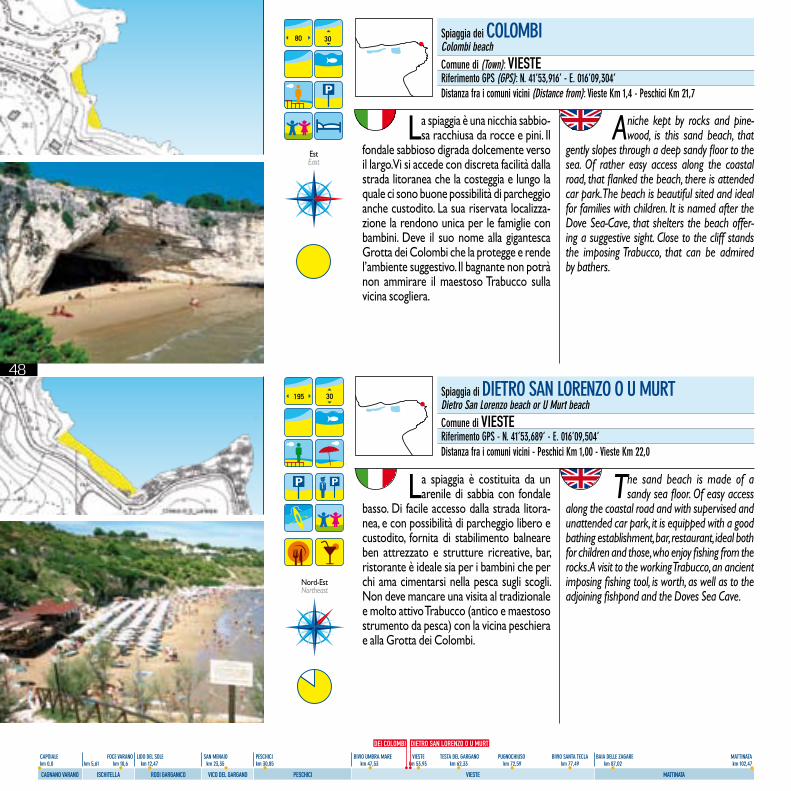
La spiaggia è costituita da un arenile di sabbia con fondale
basso. Di facile accesso dalla strada litora-nea, e con possibilità di parcheggio libero e custodito, fornita di stabilimento balneare ben attrezzato e strutture ricreative, bar, ristorante è ideale sia per i bambini che per chi ama cimentarsi nella pesca sugli scogli. Non deve mancare una visita al tradizionale e molto attivo Trabucco (antico e maestoso strumento da pesca) con la vicina peschiera e alla Grotta dei Colombi.
The sand beach is made of a sandy sea floor. Of easy access
along the coastal road and with supervised and unattended car park, it is equipped with a good bathing establishment, bar, restaurant, ideal both for children and those, who enjoy fishing from the rocks. A visit to the working Trabucco, an ancient imposing fishing tool, is worth, as well as to the adjoining fishpond and the Doves Sea Cave.
195 30
La spiaggia è una nicchia sabbio-sa racchiusa da rocce e pini. Il
fondale sabbioso digrada dolcemente verso il largo. Vi si accede con discreta facilità dalla strada litoranea che la costeggia e lungo la quale ci sono buone possibilità di parcheggio anche custodito. La sua riservata localizza-zione la rendono unica per le famiglie con bambini. Deve il suo nome alla gigantesca Grotta dei Colombi che la protegge e rende l’ambiente suggestivo. Il bagnante non potrà non ammirare il maestoso Trabucco sulla vicina scogliera.
A niche kept by rocks and pine-wood, is this sand beach, that
gently slopes through a deep sandy floor to the sea. Of rather easy access along the coastal road, that flanked the beach, there is attended car park. The beach is beautiful sited and ideal for families with children. It is named after the Dove Sea-Cave, that shelters the beach offer-ing a suggestive sight. Close to the cliff stands the imposing Trabucco, that can be admired by bathers.
80 30
Est East
Nord-EstNortheast
Spiaggia dei COLOMBIColombi beachComune di (Town): VIESTERiferimento GPS (GPS): N. 41’53,916’ - E. 016’09,304’Distanza fra i comuni vicini (Distance from): Vieste Km 1,4 - Peschici Km 21,7
Spiaggia di DIETRO SAN LORENZO O U MURTDietro San Lorenzo beach or U Murt beachComune di VIESTERiferimento GPS - N. 41’53,689’ - E. 016’09,504’Distanza fra i comuni vicini - Peschici Km 1,00 - Vieste Km 22,0
DEI COLOMBI DIETRO SAN LORENZO O U MURT
49
CAPOIALE FOCE VARANO LIDO DEL SOLE SAN MENAIO PESCHICI BIVIO UMBRA MARE VIESTE TESTA DEL GARGANO PUGNOCHIUSO BIVIO SANTA TECLA BAIA DELLE ZAGARE MATTINATA km 0,0 km 5,61 km 10,6 km 12,47 km 23,35 km 30,85 km 47,53 km 53,93 km 62,33 km 72,59 km 77,49 km 87,02 km 102,47
CAGNANO VARANO ISCHITELLA RODI GARGANICO VICO DEL GARGANO PESCHICI VIESTE MATTINATA
CONVENTO O SAN LORENZO
Spiaggia del CONVENTO O SAN LORENZOConvento or San Lorenzo beachComune di (Town): VIESTERiferimento GPS (GPS): N. 41’53,221’ - E. 016’10,013’Distanza fra i comuni vicini (Distance from): Vieste Km 0 - Peschici Km 22,2
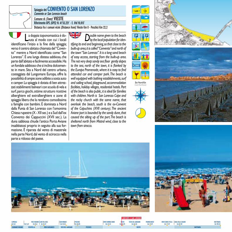
La doppia toponomastica è do-vuta al modo con cui i locali
identificano l’inizio e la fine della spiaggia; verso il centro abitato chiamata del “Coven-to” mentre a Nord identificata come “San Lorenzo”. È una lunga distesa sabbiosa, che parte dall’abitato e facilmente accessibile. Ha un fondale sabbioso che si inclina dolcemen-te in mare. Sita a Nord del centro urbano, costeggiata dal Lungomare Europa, offre la possibilità di ampie zone adibite a sosta auto e camper. La spiaggia è dotata di ben attrez-zati stabilimenti balneari con scuola di vela e surf, parco giochi, ottime strutture ricettive alberghiere ed extralberghiere e zone di spiaggia libera che la rendono comodissima a famiglie con bambini. È dominata a Nord dalla Punta di San Lorenzo con l’omonima Chiesa rupestre (X - XII sec.) e a Sud dall’ex Convento dei Cappuccini (XVII sec.). La duna sabbiosa chiude l’antico Porto Aviane insabbiatosi proprio in seguito alla sua for-mazione. È riparata dal vento di maestrale nella parte Nord, dal vento di scirocco nella parte a ridosso del paese.
Double name given to the beach by the local population for iden-
tifying its end and beginning, so that close to the built-up area, it is called “Convento” and north of the town “San Lorenzo”. It is a long sand beach of easy access, starting from the built-up area. The not very deep sandy sea floor gently slopes to the sea, north of the town, it is flanked by the Europa Promenade, where it is easy to find attended car and camper park. The beach is well equipped with bathing establishments, surf and sailing school, playground, accommodation facilities, holiday villages, residential hotels. Part of the beach is also public, it is ideal for families with children. North is San Lorenzo Cape and the rocky church with the same name, that overlook the beach, south is the ex-Convent of the Capuchins (XVII century). The ancient Aviane port is bounded by the sandy dune, that caused the silting up of the port. The beach is sheltered north from Mistral wind, close to the town from sirocco.
1400 120
Est Nord-EstEast-Northeast
50
CAPOIALE FOCE VARANO LIDO DEL SOLE SAN MENAIO PESCHICI BIVIO UMBRA MARE VIESTE TESTA DEL GARGANO PUGNOCHIUSO BIVIO SANTA TECLA BAIA DELLE ZAGARE MATTINATA km 0,0 km 5,61 km 10,6 km 12,47 km 23,35 km 30,85 km 47,53 km 53,93 km 62,33 km 72,59 km 77,49 km 87,02 km 102,47
CAGNANO VARANO ISCHITELLA RODI GARGANICO VICO DEL GARGANO PESCHICI VIESTE MATTINATA
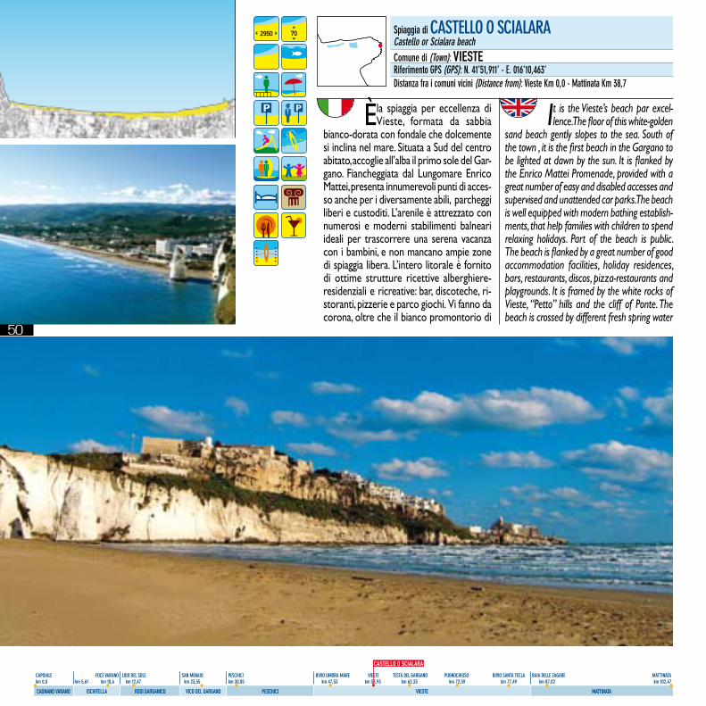
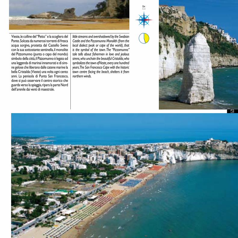
È la spiaggia per eccellenza di Vieste, formata da sabbia
bianco-dorata con fondale che dolcemente si inclina nel mare. Situata a Sud del centro abitato, accoglie all’alba il primo sole del Gar-gano. Fiancheggiata dal Lungomare Enrico Mattei, presenta innumerevoli punti di acces-so anche per i diversamente abili, parcheggi liberi e custoditi. L’arenile è attrezzato con numerosi e moderni stabilimenti balneari ideali per trascorrere una serena vacanza con i bambini, e non mancano ampie zone di spiaggia libera. L’intero litorale è fornito di ottime strutture ricettive alberghiere-residenziali e ricreative: bar, discoteche, ri-storanti, pizzerie e parco giochi. Vi fanno da corona, oltre che il bianco promontorio di
It is the Vieste’s beach par excel-lence. The floor of this white-golden
sand beach gently slopes to the sea. South of the town , it is the first beach in the Gargano to be lighted at dawn by the sun. It is flanked by the Enrico Mattei Promenade, provided with a great number of easy and disabled accesses and supervised and unattended car parks. The beach is well equipped with modern bathing establish-ments, that help families with children to spend relaxing holidays. Part of the beach is public. The beach is flanked by a great number of good accommodation facilities, holiday residences, bars, restaurants, discos, pizza-restaurants and playgrounds. It is framed by the white rocks of Vieste, “Petto” hills and the cliff of Ponte. The beach is crossed by different fresh spring water
2950 70 Spiaggia di CASTELLO O SCIALARACastello or Scialara beachComune di (Town): VIESTERiferimento GPS (GPS): N. 41’51,911’ - E. 016’10,463’Distanza fra i comuni vicini (Distance from): Vieste Km 0,0 - Mattinata Km 38,7
CASTELLO O SCIALARA
51
CAPOIALE FOCE VARANO LIDO DEL SOLE SAN MENAIO PESCHICI BIVIO UMBRA MARE VIESTE TESTA DEL GARGANO PUGNOCHIUSO BIVIO SANTA TECLA BAIA DELLE ZAGARE MATTINATA km 0,0 km 5,61 km 10,6 km 12,47 km 23,35 km 30,85 km 47,53 km 53,93 km 62,33 km 72,59 km 77,49 km 87,02 km 102,47
CAGNANO VARANO ISCHITELLA RODI GARGANICO VICO DEL GARGANO PESCHICI VIESTE MATTINATA
Vieste, le colline del “Petto” e la scogliera del Ponte. Solcata da numerosi torrenti di fresca acqua sorgiva, protetta dal Castello Svevo con la sua sottostante sentinella, il monolite del Pizzomunno (punta o capo del mondo) simbolo della città, il Pizzomunno è legato ad una leggenda di marinai innamorati e di sire-ne gelose che liberano dalle catene marine la bella Cristalda (Vieste) una volta ogni cento anni. La penisola di Punta San Francesco, dove si può osservare il centro storico che guarda verso la spiaggia, ripara la parte Nord dell’arenile dai venti di maestrale.
little streams and overshadowed by the Swabian Castle and the Pizzomunno Monolith (from the local dialect: peak or cape of the world), that is the symbol of the town. The “Pizzomunno” tale tells about fishermen in love and jealous sirens, who unchain the beautiful Cristalda, who symbolizes the town of Vieste, every one hundred years. The San Francesco Cape with the historic town centre facing the beach, shelters it from northern winds.
Est East
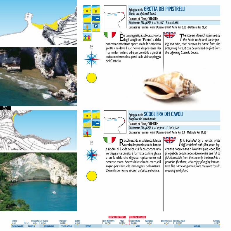
52
CAPOIALE FOCE VARANO LIDO DEL SOLE SAN MENAIO PESCHICI BIVIO UMBRA MARE VIESTE TESTA DEL GARGANO PUGNOCHIUSO BIVIO SANTA TECLA BAIA DELLE ZAGARE MATTINATA km 0,0 km 5,61 km 10,6 km 12,47 km 23,35 km 30,85 km 47,53 km 53,93 km 62,33 km 72,59 km 77,49 km 87,02 km 102,47
CAGNANO VARANO ISCHITELLA RODI GARGANICO VICO DEL GARGANO PESCHICI VIESTE MATTINATA
È una spiaggetta sabbiosa avvolta dagli scogli del “Ponte” e dalla
concava e maestosa apertura della omonima grotta che deve il suo nome alla presenza dei mammiferi volanti ed è percorribile a piedi. Si può accedere solo a piedi dalla vicina spiaggia del Castello.
The little sand beach is framed by the Ponte rocks and the impos-
ing sea cave, that borrows its name from the bats, living here. It can be reached on foot from the adjoining Castello beach.
60 25 Spiaggia della GROTTA DEI PIPISTRELLIGrotta dei pipistrelli beachComune di (Town): VIESTERiferimento GPS (GPS): N. 41’51,199’ - E. 016’10,635’Distanza fra i comuni vicini (Distance from): Vieste Km 3,00 - Mattinata Km 38,75
Spiaggia della SCOGLIERA DEI CAVOLIScogliera dei cavoli beachComune di (Town): VIESTERiferimento GPS (GPS): N. 41’49,898’ - E. 016’11,342’Distanza fra i comuni vicini (Distance from): Vieste Km 6,4 - Mattinata Km 34,62
Racchiusa da una bianca falesia carsica impreziosita da bande
e noduli di lucida selce cui fa da corona una verdeggiante pineta, è formata da fine ghiaia e un fondale che digrada rapidamente nel pescoso mare. Accessibile solo dal mare, è il sogno per chi vuole immergersi nella natura. Deve il suo nome ai caul’ un’erba selvatica.
It is bounded by a karstic white cliff, enriched with flint-stone lay-
ers and nodules and a luxuriant pine wood. The fine pebbly beach slopes down to the sea, full of fish. Accessible from the sea only, the beach is a paradise for those, who enjoy plunging into na-ture. The name originates from the word “caul”, meaning wild plant.
40 4
Est East
GROTTA DEI PIPISTRELLI SCOGLIERA DEI CAVOLI
Est East
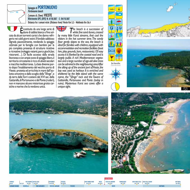
53
CAPOIALE FOCE VARANO LIDO DEL SOLE SAN MENAIO PESCHICI BIVIO UMBRA MARE VIESTE TESTA DEL GARGANO PUGNOCHIUSO BIVIO SANTA TECLA BAIA DELLE ZAGARE MATTINATA km 0,0 km 5,61 km 10,6 km 12,47 km 23,35 km 30,85 km 47,53 km 53,93 km 62,33 km 72,59 km 77,49 km 87,02 km 102,47
CAGNANO VARANO ISCHITELLA RODI GARGANICO VICO DEL GARGANO PESCHICI VIESTE MATTINATA
È costituita da una lunga serie di dune di sabbia bianca e fine sol-
cata da alcuni torrenti carsici che danno refri-gerio nei caldi giorni estivi. Il fondale sabbioso digrada piacevolmente, rendendo la spiaggia ottimale per le famiglie con bambini per la più completa presenza di strutture ricettive e ricreative (noleggio natanti, parco giochi,bar, ristoranti…). Di facile accesso dalla strada litoranea e con ampie zone di spiaggia libera, il territorio circostante è ricco di uliveti secolari e macchia mediterranea. La baia divenne por-to dopo l’insabbiamento del vecchio porto di Vieste; protetta ed arricchita in mare dall’iso-lotto omonimo e dallo scoglio della “Sfinge”, e da terra dalle Torri costiere del XVI sec. della Gattarella, di Portonuovo e del Ponte (ruderi), non vi mancano alcune misteriose grotte car-siche e marine che la rendono unica.
The beach is a succession of white fine sand dunes, crossed
by many little Karst streams, that cool the visitors in the hot summer time. The sandy floor gently slopes to the sea, the beach is ideal for families with children, equipped with accommodation and recreation facilities (boat hire, play grounds, bars, restaurants). Of easy access it is flanked by the coastal road and is largely public. A rich Mediterranean vegeta-tion and a large number of age-old olive trees can be admired in the neighbouring area. After the silting up of the ancient port of Vieste, the bay was used as harbour. It is enriched and sheltered by the little island with the same name, the “Sfinge” rock and the Towers of Gattarella, Portonuovo and Ponte (today in ruins). Mysterious Karst sea caves offer a unique sight.
Spiaggia di PORTONUOVOPortonuovo beachComune di (Town): VIESTERiferimento GPS (GPS): N. 41’50,583’ - E. 016’10,583’Distanza fra i comuni vicini (Distance from): Vieste Km 3,3 - Mattinata Km 36,4
1415 80
Est Nord-Est East-Northeast
PORTONUOVO
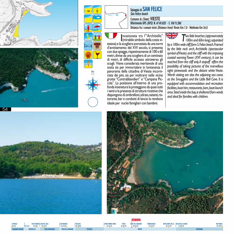
54
CAPOIALE FOCE VARANO LIDO DEL SOLE SAN MENAIO PESCHICI BIVIO UMBRA MARE VIESTE TESTA DEL GARGANO PUGNOCHIUSO BIVIO SANTA TECLA BAIA DELLE ZAGARE MATTINATA km 0,0 km 5,61 km 10,6 km 12,47 km 23,35 km 30,85 km 47,53 km 53,93 km 62,33 km 72,59 km 77,49 km 87,02 km 102,47
CAGNANO VARANO ISCHITELLA RODI GARGANICO VICO DEL GARGANO PESCHICI VIESTE MATTINATA
Incastonata tra l’“Architiello” (mirabile simbolo della costa vi-
estana) e la scogliera sovrastata da una torre d’avvistamento del XVI secolo, si presenta con due spiagge, rispettivamente di 100 e 60 metri, divise da una scogliera di un centinaio di metri, di difficile accesso attraverso gli scogli. Viene considerata meritevole di una sosta sia per immortalare in lontananza il panorama della cittadina di Vieste incorni-ciata dai pini, sia per inoltrarsi nelle vicine grotte “Contrabbandieri” e “Campana Pic-cola”. La posizione all’interno di una pro-fonda insenatura la proteggono da quasi tutti i venti e la presenza di strutture ricettive che dispongono di ombrelloni, sdraio, natanti, ris-torante, bar e condotti di lancio la rendono ideale per nuclei famigliari con bambini.
Two little beaches (approximately 100m and 60m long), separated
by a 100m wide cliff, form S. Felice beach. Framed by the little rock arch, Architiello (spectacular symbol of Vieste) and the cliff with the imposing coastal warning Tower (XVI century), it can be reached from the cliff only. A stopoff offers the possibility of taking pictures of the marvellous sight: pinewoods and the distant white Vieste. Worth visiting are also the adjoining sea caves as the Smugglers and the Little Bell Cave. It is equipped with accommodation and recreation facilities, boat hire, restaurants, bars, boat launch area. Sited inside the bay, is sheltered from winds and ideal for families with children.
160 30 Spiaggia di SAN FELICESan Felice beachComune di (Town): VIESTERiferimento GPS (GPS): N. 41’49,825’ - E. 016’11,286’Distanza fra i comuni vicini (Distance from): Vieste Km 7,0 - Mattinata Km 34,0
EstEast
SAN FELICE
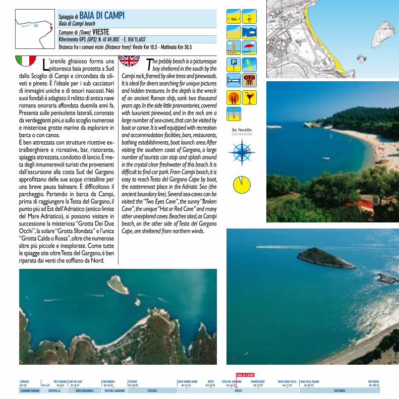
55
CAPOIALE FOCE VARANO LIDO DEL SOLE SAN MENAIO PESCHICI BIVIO UMBRA MARE VIESTE TESTA DEL GARGANO PUGNOCHIUSO BIVIO SANTA TECLA BAIA DELLE ZAGARE MATTINATA km 0,0 km 5,61 km 10,6 km 12,47 km 23,35 km 30,85 km 47,53 km 53,93 km 62,33 km 72,59 km 77,49 km 87,02 km 102,47
CAGNANO VARANO ISCHITELLA RODI GARGANICO VICO DEL GARGANO PESCHICI VIESTE MATTINATA
L’arenile ghiaioso forma una pittoresca baia protetta a Sud
dallo Scoglio di Campi e circondata da oli-veti e pinete. È l’ideale per i sub cacciatori di immagini uniche e di tesori nascosti. Nei suoi fondali è adagiato il relitto di antica nave romana onoraria affondata duemila anni fa. Presenta sulle penisolette laterali, coronate da verdeggianti pini, e sullo scoglio numerose e misteriose grotte marine da esplorare in barca o con canoa.È ben attrezzata con strutture ricettive ex-tralberghiere e ricreative, bar, ristorante, spiaggia attrezzata, condotto di lancio. È me-ta degli innumerevoli turisti che provenienti dall’escursione alla costa Sud del Gargano approfittano delle sue acque cristalline per una breve pausa balneare. È difficoltoso il parcheggio. Partendo in barca da Campi, prima di raggiungere la Testa del Gargano, il punto più ad Est dell’Adriatico (antico limite del Mare Adriatico), si possono visitare in successione la misteriosa “Grotta Dei Due Occhi”, la solare “Grotta Sfondata” e l’unica “Grotta Calda o Rossa”, oltre che numerose altre più piccole e inesplorate. Come tutte le spiagge site oltre Testa del Gargano, è ben riparata dai venti che soffiano da Nord.
The pebbly beach is a picturesque bay sheltered in the south by the
Campi rock, framed by olive trees and pinewoods. It is ideal for divers searching for unique pictures and hidden treasures. In the depth is the wreck of an ancient Roman ship, sank two thousand years ago. In the side little promontories, covered with luxuriant pinewood, and in the rock are a large number of sea-caves, that can be visited by boat or canoe. It is well equipped with recreation and accommodation facilities, bars, restaurants, bathing establishments, boat launch area. After visiting the southern coast of Gargano, a large number of tourists can stop and splash around in the crystal clear freshwater of this beach. It is difficult to find car park. From Campi beach, it is easy to reach Testa del Gargano Cape by boat, the easternmost place in the Adriatic Sea (the ancient boundary line). Several sea-caves can be visited: the “Two Eyes Cave”, the sunny “Broken Cave”, the unique “Hot or Red Cave” and many other unexplored caves. Beaches sited, as Campi beach, on the other side of Testa del Gargano Cape, are sheltered from northern winds.
Spiaggia di BAIA DI CAMPIBaia di Campi beachComune di (Town): VIESTERiferimento GPS (GPS): N. 41’49,005’ - E. 016’11,653’Distanza fra i comuni vicini (Distance from): Vieste Km 10,5 - Mattinata Km 30,5
544 40
Est Nord-Est East-Northeast
BAIA DI CAMPI
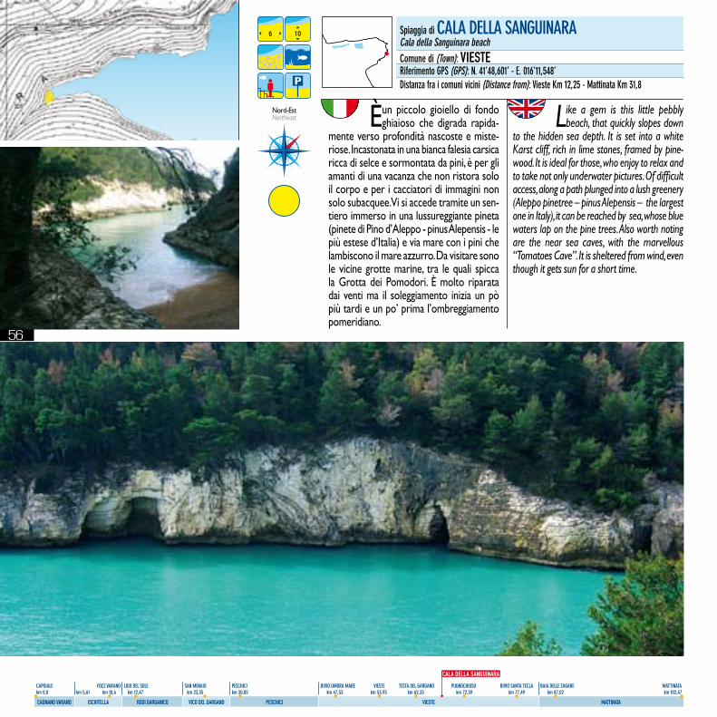
56
CAPOIALE FOCE VARANO LIDO DEL SOLE SAN MENAIO PESCHICI BIVIO UMBRA MARE VIESTE TESTA DEL GARGANO PUGNOCHIUSO BIVIO SANTA TECLA BAIA DELLE ZAGARE MATTINATA km 0,0 km 5,61 km 10,6 km 12,47 km 23,35 km 30,85 km 47,53 km 53,93 km 62,33 km 72,59 km 77,49 km 87,02 km 102,47
CAGNANO VARANO ISCHITELLA RODI GARGANICO VICO DEL GARGANO PESCHICI VIESTE MATTINATA
È un piccolo gioiello di fondo ghiaioso che digrada rapida-
mente verso profondità nascoste e miste-riose. Incastonata in una bianca falesia carsica ricca di selce e sormontata da pini, è per gli amanti di una vacanza che non ristora solo il corpo e per i cacciatori di immagini non solo subacquee. Vi si accede tramite un sen-tiero immerso in una lussureggiante pineta (pinete di Pino d’Aleppo - pinus Alepensis - le più estese d’Italia) e via mare con i pini che lambiscono il mare azzurro. Da visitare sono le vicine grotte marine, tra le quali spicca la Grotta dei Pomodori. È molto riparata dai venti ma il soleggiamento inizia un pò più tardi e un po’ prima l’ombreggiamento pomeridiano.
Like a gem is this little pebbly beach, that quickly slopes down
to the hidden sea depth. It is set into a white Karst cliff, rich in lime stones, framed by pine-wood. It is ideal for those, who enjoy to relax and to take not only underwater pictures. Of difficult access, along a path plunged into a lush greenery (Aleppo pinetree – pinus Alepensis – the largest one in Italy), it can be reached by sea, whose blue waters lap on the pine trees. Also worth noting are the near sea caves, with the marvellous “Tomatoes Cave”. It is sheltered from wind, even though it gets sun for a short time.
6 10
Nord-Est Northeast
Spiaggia di CALA DELLA SANGUINARACala della Sanguinara beachComune di (Town): VIESTERiferimento GPS (GPS): N. 41’48,601’ - E. 016’11,548’Distanza fra i comuni vicini (Distance from): Vieste Km 12,25 - Mattinata Km 31,8
CALA DELLA SANGUINARA
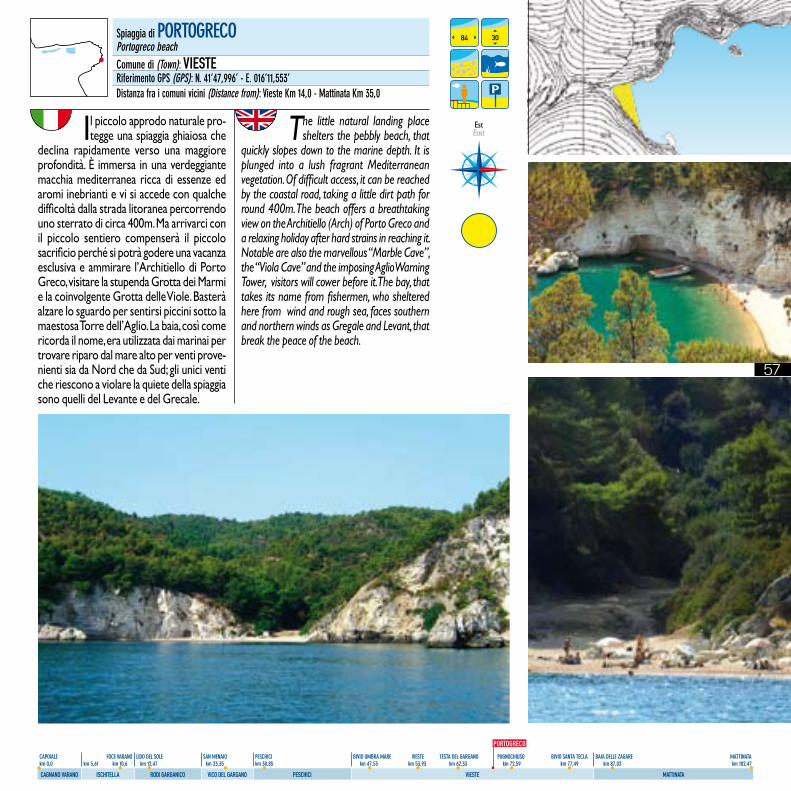
57
CAPOIALE FOCE VARANO LIDO DEL SOLE SAN MENAIO PESCHICI BIVIO UMBRA MARE VIESTE TESTA DEL GARGANO PUGNOCHIUSO BIVIO SANTA TECLA BAIA DELLE ZAGARE MATTINATA km 0,0 km 5,61 km 10,6 km 12,47 km 23,35 km 30,85 km 47,53 km 53,93 km 62,33 km 72,59 km 77,49 km 87,02 km 102,47
CAGNANO VARANO ISCHITELLA RODI GARGANICO VICO DEL GARGANO PESCHICI VIESTE MATTINATA
Il piccolo approdo naturale pro-tegge una spiaggia ghiaiosa che
declina rapidamente verso una maggiore profondità. È immersa in una verdeggiante macchia mediterranea ricca di essenze ed aromi inebrianti e vi si accede con qualche difficoltà dalla strada litoranea percorrendo uno sterrato di circa 400m. Ma arrivarci con il piccolo sentiero compenserà il piccolo sacrificio perché si potrà godere una vacanza esclusiva e ammirare l’Architiello di Porto Greco, visitare la stupenda Grotta dei Marmi e la coinvolgente Grotta delle Viole. Basterà alzare lo sguardo per sentirsi piccini sotto la maestosa Torre dell’Aglio. La baia, così come ricorda il nome, era utilizzata dai marinai per trovare riparo dal mare alto per venti prove-nienti sia da Nord che da Sud; gli unici venti che riescono a violare la quiete della spiaggia sono quelli del Levante e del Grecale.
The little natural landing place shelters the pebbly beach, that
quickly slopes down to the marine depth. It is plunged into a lush fragrant Mediterranean vegetation. Of difficult access, it can be reached by the coastal road, taking a little dirt path for round 400m. The beach offers a breathtaking view on the Architiello (Arch) of Porto Greco and a relaxing holiday after hard strains in reaching it. Notable are also the marvellous “Marble Cave”, the “Viola Cave” and the imposing Aglio Warning Tower, visitors will cower before it. The bay, that takes its name from fishermen, who sheltered here from wind and rough sea, faces southern and northern winds as Gregale and Levant, that break the peace of the beach.
84 30Spiaggia di PORTOGRECOPortogreco beachComune di (Town): VIESTERiferimento GPS (GPS): N. 41’47,996’ - E. 016’11,553’Distanza fra i comuni vicini (Distance from): Vieste Km 14,0 - Mattinata Km 35,0
Est East
PORTOGRECO
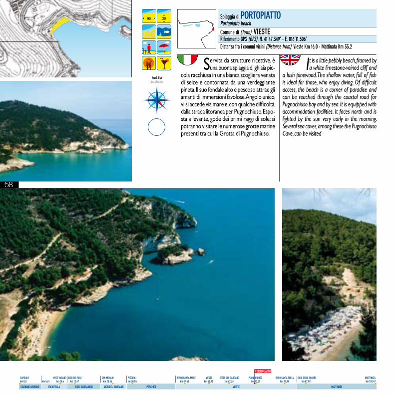
58
CAPOIALE FOCE VARANO LIDO DEL SOLE SAN MENAIO PESCHICI BIVIO UMBRA MARE VIESTE TESTA DEL GARGANO PUGNOCHIUSO BIVIO SANTA TECLA BAIA DELLE ZAGARE MATTINATA km 0,0 km 5,61 km 10,6 km 12,47 km 23,35 km 30,85 km 47,53 km 53,93 km 62,33 km 72,59 km 77,49 km 87,02 km 102,47
CAGNANO VARANO ISCHITELLA RODI GARGANICO VICO DEL GARGANO PESCHICI VIESTE MATTINATA
Servita da strutture ricettive, è una buona spiaggia di ghiaia pic-
cola racchiusa in una bianca scogliera venata di selce e contornata da una verdeggiante pineta. Il suo fondale alto e pescoso attrae gli amanti di immersioni favolose. Angolo unico, vi si accede via mare e, con qualche difficoltà, dalla strada litoranea per Pugnochiuso. Espo-sta a levante, gode dei primi raggi di sole; si potranno visitare le numerose grotte marine presenti tra cui la Grotta di Pugnochiuso.
It is a little pebbly beach, framed by a white limestone-veined cliff and
a lush pinewood. The shallow water, full of fish is ideal for those, who enjoy diving. Of difficult access, the beach is a corner of paradise and can be reached through the coastal road for Pugnochiuso bay and by sea. It is equipped with accommodation facilities. It faces north and is lighted by the sun very early in the morning. Several sea caves, among these the Pugnochiuso Cave, can be visited
Sud-EstSoutheast
90 20 Spiaggia di PORTOPIATTOPortopiatto beachComune di (Town): VIESTERiferimento GPS (GPS): N. 41’47,349’ - E. 016’11,306’Distanza fra i comuni vicini (Distance from): Vieste Km 16,0 - Mattinata Km 33,2
PORTOPIATTO
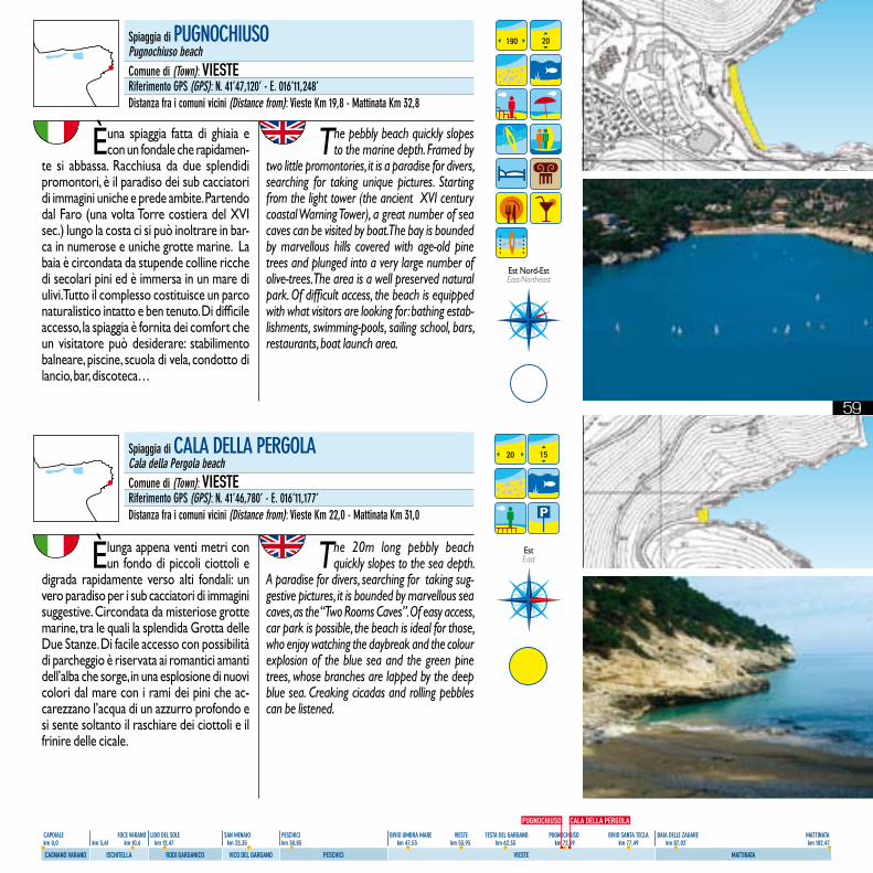
59
CAPOIALE FOCE VARANO LIDO DEL SOLE SAN MENAIO PESCHICI BIVIO UMBRA MARE VIESTE TESTA DEL GARGANO PUGNOCHIUSO BIVIO SANTA TECLA BAIA DELLE ZAGARE MATTINATA km 0,0 km 5,61 km 10,6 km 12,47 km 23,35 km 30,85 km 47,53 km 53,93 km 62,33 km 72,59 km 77,49 km 87,02 km 102,47
CAGNANO VARANO ISCHITELLA RODI GARGANICO VICO DEL GARGANO PESCHICI VIESTE MATTINATA
È una spiaggia fatta di ghiaia e con un fondale che rapidamen-
te si abbassa. Racchiusa da due splendidi promontori, è il paradiso dei sub cacciatori di immagini uniche e prede ambite. Partendo dal Faro (una volta Torre costiera del XVI sec.) lungo la costa ci si può inoltrare in bar-ca in numerose e uniche grotte marine. La baia è circondata da stupende colline ricche di secolari pini ed è immersa in un mare di ulivi. Tutto il complesso costituisce un parco naturalistico intatto e ben tenuto. Di difficile accesso, la spiaggia è fornita dei comfort che un visitatore può desiderare: stabilimento balneare, piscine, scuola di vela, condotto di lancio, bar, discoteca…
The pebbly beach quickly slopes to the marine depth. Framed by
two little promontories, it is a paradise for divers, searching for taking unique pictures. Starting from the light tower (the ancient XVI century coastal Warning Tower), a great number of sea caves can be visited by boat. The bay is bounded by marvellous hills covered with age-old pine trees and plunged into a very large number of olive-trees. The area is a well preserved natural park. Of difficult access, the beach is equipped with what visitors are looking for: bathing estab-lishments, swimming-pools, sailing school, bars, restaurants, boat launch area.
190 20
Est Nord-Est East-Northeast
È lunga appena venti metri con un fondo di piccoli ciottoli e
digrada rapidamente verso alti fondali: un vero paradiso per i sub cacciatori di immagini suggestive. Circondata da misteriose grotte marine, tra le quali la splendida Grotta delle Due Stanze. Di facile accesso con possibilità di parcheggio è riservata ai romantici amanti dell’alba che sorge, in una esplosione di nuovi colori dal mare con i rami dei pini che ac-carezzano l’acqua di un azzurro profondo e si sente soltanto il raschiare dei ciottoli e il frinire delle cicale.
The 20m long pebbly beach quickly slopes to the sea depth.
A paradise for divers, searching for taking sug-gestive pictures, it is bounded by marvellous sea caves, as the “Two Rooms Caves”. Of easy access, car park is possible, the beach is ideal for those, who enjoy watching the daybreak and the colour explosion of the blue sea and the green pine trees, whose branches are lapped by the deep blue sea. Creaking cicadas and rolling pebbles can be listened.
20 15
EstEast
Spiaggia di PUGNOCHIUSOPugnochiuso beachComune di (Town): VIESTERiferimento GPS (GPS): N. 41’47,120’ - E. 016’11,248’Distanza fra i comuni vicini (Distance from): Vieste Km 19,8 - Mattinata Km 32,8
Spiaggia di CALA DELLA PERGOLACala della Pergola beachComune di (Town): VIESTERiferimento GPS (GPS): N. 41’46,780’ - E. 016’11,177’Distanza fra i comuni vicini (Distance from): Vieste Km 22,0 - Mattinata Km 31,0
PUGNOCHIUSO CALA DELLA PERGOLA
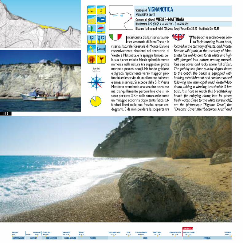
60
CAPOIALE FOCE VARANO LIDO DEL SOLE SAN MENAIO PESCHICI BIVIO UMBRA MARE VIESTE TESTA DEL GARGANO PUGNOCHIUSO BIVIO SANTA TECLA BAIA DELLE ZAGARE MATTINATA km 0,0 km 5,61 km 10,6 km 12,47 km 23,35 km 30,85 km 47,53 km 53,93 km 62,33 km 72,59 km 77,49 km 87,02 km 102,47
CAGNANO VARANO ISCHITELLA RODI GARGANICO VICO DEL GARGANO PESCHICI VIESTE MATTINATA
Incastonata tra la riserva faunis-tica venatoria di Santa Tecla e la
riserva naturale forestale di Monte Barone rispettivamente ricadenti nel territorio di Vieste e Mattinata, è la spiaggia famosa per la sua bianca ed alta falesia splendidamente immersa nella natura tra suggestive grotte marine e pescosi scogli. Ha fondo ghiaioso e digrada rapidamente verso maggiori pro-fondità ed è servita da stabilimento balneare e annessi servizi. Si accede dalla S. P. Vieste Mattinata prendendo una stradina tortuosa ma tranquillamente percorribile che si in-sinua per circa 3 Km nella natura ed è come un miraggio scoprirla dopo tanta fatica tuf-fandosi liberi nelle sue fresche acque ver-deggianti. È da non perdere la scoperta tra
The beach is set between San-ta Tecla hunting fauna park,
located in the territory of Vieste, and Monte Barone wild park, in the territory of Mat-tinata. It is well-known for its white and high cliff, plunged into nature among marvel-lous sea caves and rocky shore full of fish. The pebbly sea floor quickly slopes down to the depth; the beach is equipped with bathing establishment and can be reached following the municipal road Vieste/Mat-tinata, taking a winding practicable 3 km path. It is hard to reach this breathtaking beach for enjoying diving into its green fresh water. Close to the white karstic cliff, are the picturesque “Pigeous Cave”, the “Dreams Cave”, the “Lacework Arch” and
780 40 Spiaggia di VIGNANOTICAVignanotica beachComune di (Town): VIESTE-MATTINATARiferimento GPS (GPS): N. 41’45,719’ - E. 016’09,939’Distanza fra i comuni vicini (Distance from): Vieste Km 23,29 - Mattinata Km 22,85
Sud-EstSoutheast
VIGNANOTICA
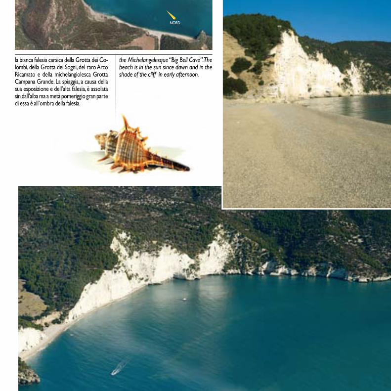
61
CAPOIALE FOCE VARANO LIDO DEL SOLE SAN MENAIO PESCHICI BIVIO UMBRA MARE VIESTE TESTA DEL GARGANO PUGNOCHIUSO BIVIO SANTA TECLA BAIA DELLE ZAGARE MATTINATA km 0,0 km 5,61 km 10,6 km 12,47 km 23,35 km 30,85 km 47,53 km 53,93 km 62,33 km 72,59 km 77,49 km 87,02 km 102,47
CAGNANO VARANO ISCHITELLA RODI GARGANICO VICO DEL GARGANO PESCHICI VIESTE MATTINATA
la bianca falesia carsica della Grotta dei Co-lombi, della Grotta dei Sogni, del raro Arco Ricamato e della michelangiolesca Grotta Campana Grande. La spiaggia, a causa della sua esposizione e dell’alta falesia, è assolata sin dall’alba ma a metà pomeriggio gran parte di essa è all’ombra della falesia.
the Michelangelesque “Big Bell Cave”. The beach is in the sun since dawn and in the shade of the cliff in early afternoon.
NORD

62
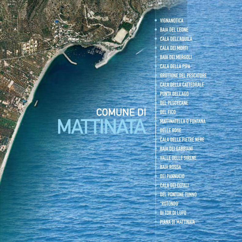
63
CAPOIALE FOCE VARANO LIDO DEL SOLE SAN MENAIO PESCHICI BIVIO UMBRA MARE VIESTE TESTA DEL GARGANO PUGNOCHIUSO BIVIO SANTA TECLA BAIA DELLE ZAGARE MATTINATA km 0,0 km 5,61 km 10,6 km 12,47 km 23,35 km 30,85 km 47,53 km 53,93 km 62,33 km 72,59 km 77,49 km 87,02 km 102,47
CAGNANO VARANO ISCHITELLA RODI GARGANICO VICO DEL GARGANO PESCHICI VIESTE MATTINATA
comune di
mATTinATA
• VIGNANOTICA
• BAIA DEL LEONE
• CALA DELL’AQUILA
• CALA DEI MORTI
• BAIA DEI MERGOLI
• CALA DELLA PIPA
• GROTTONE DEL PESCATORE
• CALA DELLA CATTEDRALE
• PUNTA DELL’AGO
• DEL PESCECANE
• DEL FICO
• MATTINATELLA O FONTANA
DELLE ROSE
• CALA DELLE PIETRE NERE
• BAIA DEI GABBIANI
• VALLE DELLE SIRENE
• BAIA ROSSA
• DEI PANNUCID
• CALA DEI CEFALI
• DEL PONTONE TUNNO
“ROTONDO”
• DI TOR DI LUPO
• PIANA DI MATTINATA
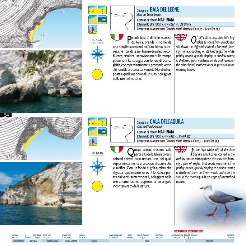
64
CAPOIALE FOCE VARANO LIDO DEL SOLE SAN MENAIO PESCHICI BIVIO UMBRA MARE VIESTE TESTA DEL GARGANO PUGNOCHIUSO BIVIO SANTA TECLA BAIA DELLE ZAGARE MATTINATA km 0,0 km 5,61 km 10,6 km 12,47 km 23,35 km 30,85 km 47,53 km 53,93 km 62,33 km 72,59 km 77,49 km 87,02 km 102,47
CAGNANO VARANO ISCHITELLA RODI GARGANICO VICO DEL GARGANO PESCHICI VIESTE MATTINATA
Piccola baia di difficile accesso da terra, prende il nome da
uno scoglio staccatosi dall’alta falesia calca-rea, che ricorda le sembianze di un leone con fluente criniera accovacciato sulle zampe posteriori. La spiaggia con fondo di bianca ghiaia, che repentinamente si protende verso alti fondali, protetta dai venti da Nord ed es-posta a quelli meridionali, risulta soleggiata nelle ore del mattino.
Of difficult access, this little bay takes its name from a rock, that
slid down the cliff and shaped a lion with flow-ing mane, crouching on its hind legs. The white pebbly beach, quickly sloping to shallow water, is sheltered from northern winds and faces, on the other hand, southern ones. It gets sun in the morning hours.
Questa caletta presenta sulla parte alta della falesia diversi
anfratti scavati dalla natura, uno dei quali ospita annualmente una coppia di aquile che vi nidifica. Con un fondo di ghiaia mista che digrada rapidamente verso il fondale, ripar-ata dai venti settentrionali, soleggiata nelle ore antimeridiane, rappresenta un angolo incontaminato della natura.
In the high white cliff of this little bay are small caves carved in the
rock by nature, among these, the sea cave, hous-ing a pair of eagles, that yearly nests here. The pebbly beach, quickly sloping to shallow water, is sheltered from northern winds and is in the sun in the morning. It is an edge of untouched nature.
70
50
6
4
Spiaggia di BAIA DEL LEONEBaia del Leone beachComune di (Town): MATTINATARiferimento GPS (GPS): N. 41’45,227’ - E. 016’09,615’Distanza fra i comuni vicini (Distance from): Mattinata Km 16,15 - Vieste Km 24,6
Spiaggia di CALA DELL’AQUILACala dell’Aquila beachComune di (Town): MATTINATARiferimento GPS (GPS): N. 41’45,082 - E. 016’09,362’Distanza fra i comuni vicini (Distance from): Mattinata Km 15,7 - Vieste Km 24,1
BAIA DEL LEONE CALA DELL’AQUILA
Est Sud-Est East-Southeast
Est Sud-Est East-Southeast
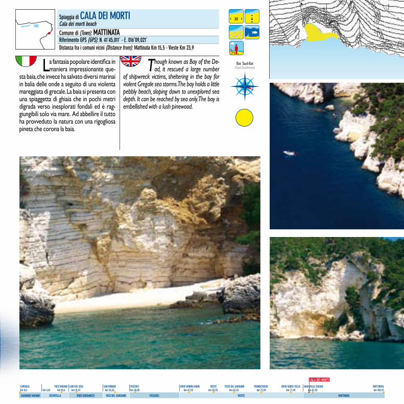
65
CAPOIALE FOCE VARANO LIDO DEL SOLE SAN MENAIO PESCHICI BIVIO UMBRA MARE VIESTE TESTA DEL GARGANO PUGNOCHIUSO BIVIO SANTA TECLA BAIA DELLE ZAGARE MATTINATA km 0,0 km 5,61 km 10,6 km 12,47 km 23,35 km 30,85 km 47,53 km 53,93 km 62,33 km 72,59 km 77,49 km 87,02 km 102,47
CAGNANO VARANO ISCHITELLA RODI GARGANICO VICO DEL GARGANO PESCHICI VIESTE MATTINATA
La fantasia popolare identifica in maniera impressionante que-
sta baia, che invece ha salvato diversi marinai in balia delle onde a seguito di una violenta mareggiata di grecale. La baia si presenta con una spiaggetta di ghiaia che in pochi metri digrada verso inesplorati fondali ed è rag-giungibili solo via mare. Ad abbellire il tutto ha provveduto la natura con una rigogliosa pineta che corona la baia.
Though known as Bay of the De-ad, it rescued a large number
of shipwreck victims, sheltering in the bay for violent Gregale sea storms. The bay holds a little pebbly beach, sloping down to unexplored sea depth. It can be reached by sea only. The bay is embellished with a lush pinewood.
20 4Spiaggia di CALA DEI MORTICala dei morti beachComune di (Town): MATTINATARiferimento GPS (GPS): N. 41’45,011’ - E. 016’09,021’Distanza fra i comuni vicini (Distance from): Mattinata Km 15,5 - Vieste Km 23,9
CALA DEI MORTI
Est Sud-Est East-Southeast
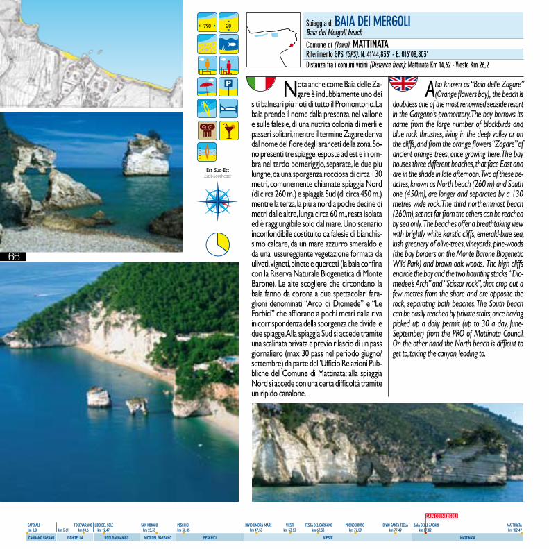
66
CAPOIALE FOCE VARANO LIDO DEL SOLE SAN MENAIO PESCHICI BIVIO UMBRA MARE VIESTE TESTA DEL GARGANO PUGNOCHIUSO BIVIO SANTA TECLA BAIA DELLE ZAGARE MATTINATA km 0,0 km 5,61 km 10,6 km 12,47 km 23,35 km 30,85 km 47,53 km 53,93 km 62,33 km 72,59 km 77,49 km 87,02 km 102,47
CAGNANO VARANO ISCHITELLA RODI GARGANICO VICO DEL GARGANO PESCHICI VIESTE MATTINATA
Nota anche come Baia delle Za-gare è indubbiamente uno dei
siti balneari più noti di tutto il Promontorio. La baia prende il nome dalla presenza, nel vallone e sulle falesie, di una nutrita colonia di merli e passeri solitari, mentre il termine Zagare deriva dal nome del fiore degli aranceti della zona. So-no presenti tre spiagge, esposte ad est e in om-bra nel tardo pomeriggio, separate, le due piu lunghe, da una sporgenza rocciosa di circa 130 metri, comunemente chiamate spiaggia Nord (di circa 260 m.) e spiaggia Sud (di circa 450 m.) mentre la terza, la più a nord a poche decine di metri dalle altre, lunga circa 60 m., resta isolata ed è raggiungibile solo dal mare. Uno scenario inconfondibile costituito da falesie di bianchis-simo calcare, da un mare azzurro smeraldo e da una lussureggiante vegetazione formata da uliveti, vigneti, pinete e querceti (la baia confina con la Riserva Naturale Biogenetica di Monte Barone). Le alte scogliere che circondano la baia fanno da corona a due spettacolari fara-glioni denominati “Arco di Diomede” e “Le Forbici” che affiorano a pochi metri dalla riva in corrispondenza della sporgenza che divide le due spiagge. Alla spiaggia Sud si accede tramite una scalinata privata e previo rilascio di un pass giornaliero (max 30 pass nel periodo giugno/settembre) da parte dell’Ufficio Relazioni Pub-bliche del Comune di Mattinata; alla spiaggia Nord si accede con una certa difficoltà tramite un ripido canalone.
Also known as “Baia delle Zagare” (Orange flowers bay), the beach is
doubtless one of the most renowned seaside resort in the Gargano’s promontory. The bay borrows its name from the large number of blackbirds and blue rock thrushes, living in the deep valley or on the cliffs, and from the orange flowers “Zagare” of ancient orange trees, once growing here. The bay houses three different beaches, that face East and are in the shade in late afternoon. Two of these be-aches, known as North beach (260 m) and South one (450m), are longer and separated by a 130 metres wide rock. The third northernmost beach (260m), set not far from the others can be reached by sea only. The beaches offer a breathtaking view with brightly white karstic cliffs, emerald-blue sea, lush greenery of olive-trees, vineyards, pine-woods (the bay borders on the Monte Barone Biogenetic Wild Park) and brown oak woods. The high cliffs encircle the bay and the two haunting stacks “Dio-medee’s Arch” and “Scissor rock”, that crop out a few metres from the shore and are opposite the rock, separating both beaches. The South beach can be easily reached by private stairs, once having picked up a daily permit (up to 30 a day, June-September) from the PRO of Mattinata Council. On the other hand the North beach is difficult to get to, taking the canyon, leading to.
790 20 Spiaggia di BAIA DEI MERGOLIBaia dei Mergoli beachComune di (Town): MATTINATARiferimento GPS (GPS): N. 41’44,833’ - E. 016’08,803’Distanza fra i comuni vicini (Distance from): Mattinata Km 14,62 - Vieste Km 26,2
BAIA DEI MERGOLI
Est Sud-Est East-Southeast
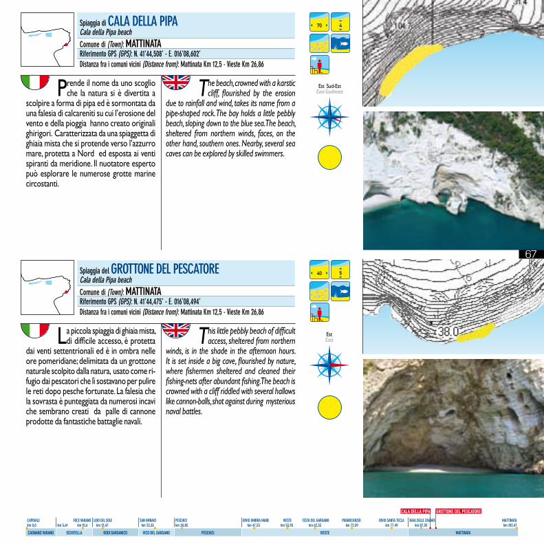
67
CAPOIALE FOCE VARANO LIDO DEL SOLE SAN MENAIO PESCHICI BIVIO UMBRA MARE VIESTE TESTA DEL GARGANO PUGNOCHIUSO BIVIO SANTA TECLA BAIA DELLE ZAGARE MATTINATA km 0,0 km 5,61 km 10,6 km 12,47 km 23,35 km 30,85 km 47,53 km 53,93 km 62,33 km 72,59 km 77,49 km 87,02 km 102,47
CAGNANO VARANO ISCHITELLA RODI GARGANICO VICO DEL GARGANO PESCHICI VIESTE MATTINATA
Prende il nome da uno scoglio che la natura si è divertita a
scolpire a forma di pipa ed è sormontata da una falesia di calcareniti su cui l’erosione del vento e della pioggia hanno creato originali ghirigori. Caratterizzata da una spiaggetta di ghiaia mista che si protende verso l’azzurro mare, protetta a Nord ed esposta ai venti spiranti da meridione. Il nuotatore esperto può esplorare le numerose grotte marine circostanti.
The beach, crowned with a karstic cliff, flourished by the erosion
due to rainfall and wind, takes its name from a pipe-shaped rock. The bay holds a little pebbly beach, sloping down to the blue sea. The beach, sheltered from northern winds, faces, on the other hand, southern ones. Nearby, several sea caves can be explored by skilled swimmers.
La piccola spiaggia di ghiaia mista, di difficile accesso, è protetta
dai venti settentrionali ed è in ombra nelle ore pomeridiane; delimitata da un grottone naturale scolpito dalla natura, usato come ri-fugio dai pescatori che lì sostavano per pulire le reti dopo pesche fortunate. La falesia che la sovrasta è punteggiata da numerosi incavi che sembrano creati da palle di cannone prodotte da fantastiche battaglie navali.
This little pebbly beach of difficult access, sheltered from northern
winds, is in the shade in the afternoon hours. It is set inside a big cave, flourished by nature, where fishermen sheltered and cleaned their fishing-nets after abundant fishing. The beach is crowned with a cliff riddled with several hallows like cannon-balls, shot against during mysterious naval battles.
70
40
4
5
Spiaggia di CALA DELLA PIPACala della Pipa beachComune di (Town): MATTINATARiferimento GPS (GPS): N. 41’44,508’ - E. 016’08,602’Distanza fra i comuni vicini (Distance from): Mattinata Km 12,5 - Vieste Km 26,86
Spiaggia del GROTTONE DEL PESCATORECala della Pipa beachComune di (Town): MATTINATARiferimento GPS (GPS): N. 41’44,475’ - E. 016’08,494’Distanza fra i comuni vicini (Distance from): Mattinata Km 12,5 - Vieste Km 26,86
EstEast
CALA DELLA PIPA GROTTONE DEL PESCATORE
Est Sud-Est East-Southeast
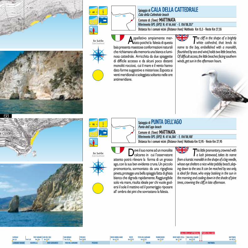
68
CAPOIALE FOCE VARANO LIDO DEL SOLE SAN MENAIO PESCHICI BIVIO UMBRA MARE VIESTE TESTA DEL GARGANO PUGNOCHIUSO BIVIO SANTA TECLA BAIA DELLE ZAGARE MATTINATA km 0,0 km 5,61 km 10,6 km 12,47 km 23,35 km 30,85 km 47,53 km 53,93 km 62,33 km 72,59 km 77,49 km 87,02 km 102,47
CAGNANO VARANO ISCHITELLA RODI GARGANICO VICO DEL GARGANO PESCHICI VIESTE MATTINATA
Appellativo ampiamente mer-itato poiché la falesia di questa
baia presenta maestose conformazioni naturali che richiamano alla memoria una bianca e lumi-nosa cattedrale. Arricchita da due spiaggette di difficile accesso e da alcuni poco distanti monoliti rocciosi, cui il mare e il vento hanno dato forme suggestive e misteriose. Esposta ai venti meridionali e soleggiata soltanto nelle ore antimeridiane.
The cliff in the shape of a brightly white cathedral, that lends its
name to the bay, embellished with a monolith, flourished by sea and wind, holds two little beaches. Of difficult access, the little beaches facing southern winds, get sun in the afternoon hours.
Deve il suo nome ad un monolite calcareo in cui l’osservatore
attento potrà rilevare la forma di un grosso ago, con la sua ben evidente cruna. Un piccolo promontorio, sormontato da una rigogliosa pineta, protegge una bella spiaggia fatta di ghiaia bianca che digrada rapidamente. Raggiungibile solo via mare, risulta ideale per chi vuole god-ersi il sole il mattino ed il pomeriggio riposare all’ ombra dei pini che sovrastano la falesia.
This little promontory, crowned with a lush pinewood, takes its name
from a karstic monolith in the shape of a big needle, whose eye shelters a nice white pebbly beach, slop-ing down to the sea. It can be reached by sea only, is ideal for those, who enjoy basking in the sun in the morning and cooling down in the shade of pine trees, crowning the cliff, in late afternoon.
Spiaggia di CALA DELLA CATTEDRALECala della Cattedrale beachComune di (Town): MATTINATARiferimento GPS (GPS): N. 41’44,446’ - E. 016’08,357’Distanza fra i comuni vicini (Distance from): Mattinata Km 13,3 - Vieste Km 27,55
Spiaggia di PUNTA DELL’AGOPunta dell’ago beachComune di (Town): MATTINATARiferimento GPS (GPS): N. 41’44,384’ - E. 016’08,100’Distanza fra i comuni vicini (Distance from): Mattinata Km 12,95 - Vieste Km 27,95
60
90
5
7
PUNTA DELL’AGOCALA DELLA CATTREDALE
Est Sud-Est East-Southeast
Est Sud-Est East-Southeast
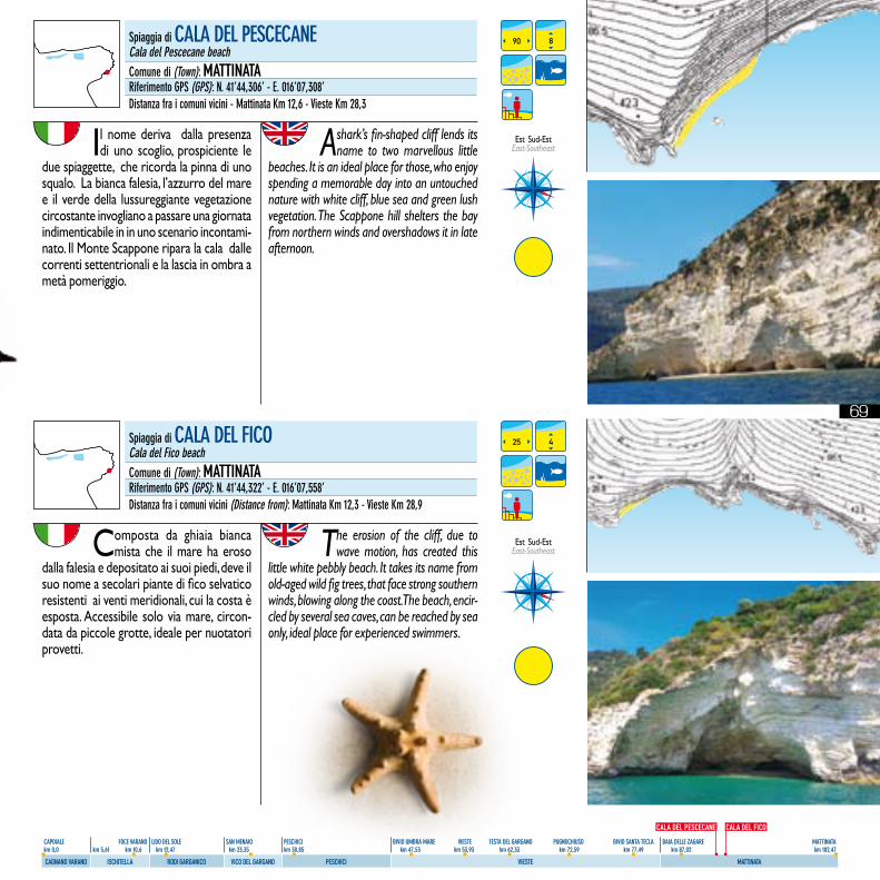
69
CAPOIALE FOCE VARANO LIDO DEL SOLE SAN MENAIO PESCHICI BIVIO UMBRA MARE VIESTE TESTA DEL GARGANO PUGNOCHIUSO BIVIO SANTA TECLA BAIA DELLE ZAGARE MATTINATA km 0,0 km 5,61 km 10,6 km 12,47 km 23,35 km 30,85 km 47,53 km 53,93 km 62,33 km 72,59 km 77,49 km 87,02 km 102,47
CAGNANO VARANO ISCHITELLA RODI GARGANICO VICO DEL GARGANO PESCHICI VIESTE MATTINATA
Il nome deriva dalla presenza di uno scoglio, prospiciente le
due spiaggette, che ricorda la pinna di uno squalo. La bianca falesia, l’azzurro del mare e il verde della lussureggiante vegetazione circostante invogliano a passare una giornata indimenticabile in in uno scenario incontami-nato. Il Monte Scappone ripara la cala dalle correnti settentrionali e la lascia in ombra a metà pomeriggio.
A shark’s fin-shaped cliff lends its name to two marvellous little
beaches. It is an ideal place for those, who enjoy spending a memorable day into an untouched nature with white cliff, blue sea and green lush vegetation. The Scappone hill shelters the bay from northern winds and overshadows it in late afternoon.
Composta da ghiaia bianca mista che il mare ha eroso
dalla falesia e depositato ai suoi piedi, deve il suo nome a secolari piante di fico selvatico resistenti ai venti meridionali, cui la costa è esposta. Accessibile solo via mare, circon-data da piccole grotte, ideale per nuotatori provetti.
The erosion of the cliff, due to wave motion, has created this
little white pebbly beach. It takes its name from old-aged wild fig trees, that face strong southern winds, blowing along the coast. The beach, encir-cled by several sea caves, can be reached by sea only, ideal place for experienced swimmers.
90
25
8
4
Spiaggia di CALA DEL PESCECANECala del Pescecane beachComune di (Town): MATTINATARiferimento GPS (GPS): N. 41’44,306’ - E. 016’07,308’Distanza fra i comuni vicini - Mattinata Km 12,6 - Vieste Km 28,3
Spiaggia di CALA DEL fICOCala del fico beachComune di (Town): MATTINATARiferimento GPS (GPS): N. 41’44,322’ - E. 016’07,558’Distanza fra i comuni vicini (Distance from): Mattinata Km 12,3 - Vieste Km 28,9
CALA DEL PESCECANE CALA DEL FICO
Est Sud-Est East-Southeast
Est Sud-Est East-Southeast
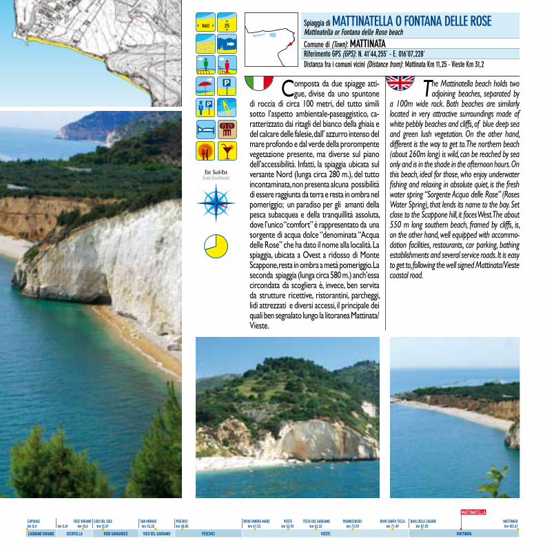
70
CAPOIALE FOCE VARANO LIDO DEL SOLE SAN MENAIO PESCHICI BIVIO UMBRA MARE VIESTE TESTA DEL GARGANO PUGNOCHIUSO BIVIO SANTA TECLA BAIA DELLE ZAGARE MATTINATA km 0,0 km 5,61 km 10,6 km 12,47 km 23,35 km 30,85 km 47,53 km 53,93 km 62,33 km 72,59 km 77,49 km 87,02 km 102,47
CAGNANO VARANO ISCHITELLA RODI GARGANICO VICO DEL GARGANO PESCHICI VIESTE MATTINATA
Composta da due spiagge atti-gue, divise da uno spuntone
di roccia di circa 100 metri, del tutto simili sotto l’aspetto ambientale-paseaggistico, ca-ratterizzato dai ritagli del bianco della ghiaia e del calcare delle falesie, dall’ azzurro intenso del mare profondo e dal verde della prorompente vegetazione presente, ma diverse sul piano dell’accessibilità. Infatti, la spiaggia ubicata sul versante Nord (lunga circa 280 m.), del tutto incontaminata, non presenta alcuna possibilità di essere raggiunta da terra e resta in ombra nel pomeriggio; un paradiso per gli amanti della pesca subacquea e della tranquillità assoluta, dove l’unico “comfort” è rappresentato da una sorgente di acqua dolce “denominata “Acqua delle Rose” che ha dato il nome alla località. La spiaggia, ubicata a Ovest a ridosso di Monte Scappone, resta in ombra a metà pomeriggio. La seconda spiaggia (lunga circa 580 m.) anch’essa circondata da scogliera è, invece, ben servita da strutture ricettive, ristorantini, parcheggi, lidi attrezzati e diversi accessi, il principale dei quali ben segnalato lungo la litoranea Mattinata/Vieste.
The Mattinatella beach holds two adjoining beaches, separated by
a 100m wide rock. Both beaches are similarly located in very attractive surroundings made of white pebbly beaches and cliffs, of blue deep sea and green lush vegetation. On the other hand, different is the way to get to. The northern beach (about 260m long) is wild, can be reached by sea only and is in the shade in the afternoon hours. On this beach, ideal for those, who enjoy underwater fishing and relaxing in absolute quiet, is the fresh water spring “Sorgente Acqua delle Rose” (Roses Water Spring), that lends its name to the bay. Set close to the Scappone hill, it faces West. The about 550 m long southern beach, framed by cliffs, is, on the other hand, well equipped with accommo-dation facilities, restaurants, car parking, bathing establishments and several service roads. It is easy to get to, following the well signed Mattinata/Vieste coastal road.
860 25 Spiaggia di MATTINATELLA O fONTANA DELLE ROSEMattinatella or fontana delle Rose beachComune di (Town): MATTINATARiferimento GPS (GPS): N. 41’44,255’ - E. 016’07,228’Distanza fra i comuni vicini (Distance from): Mattinata Km 11,25 - Vieste Km 31,2
MATTINATELLA
Est Sud-Est East-Southeast
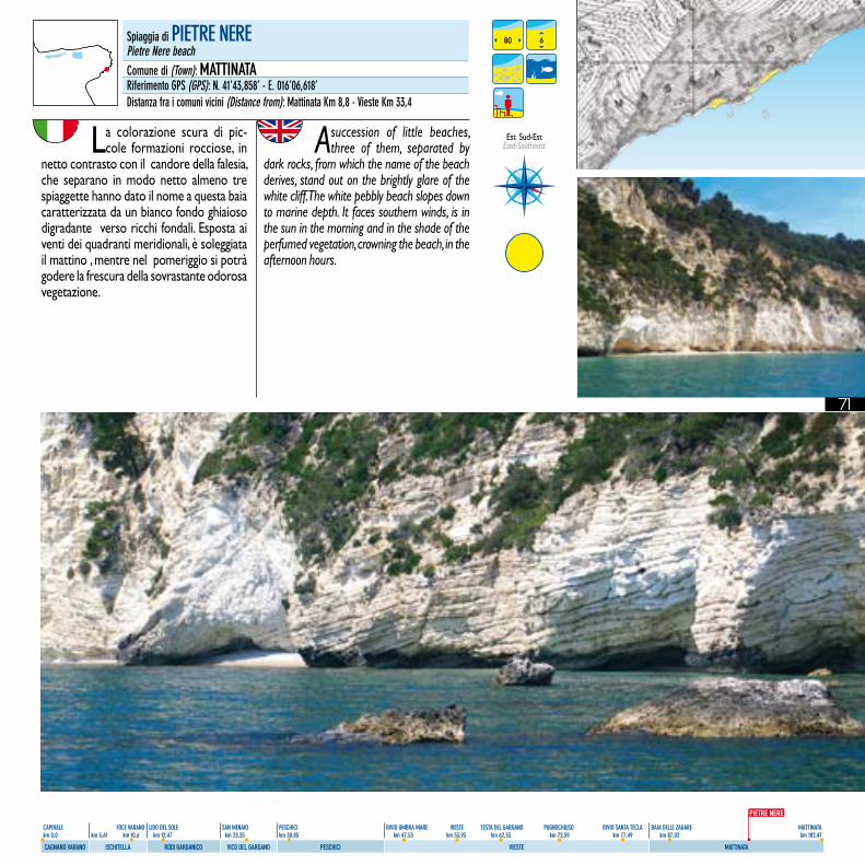
71
CAPOIALE FOCE VARANO LIDO DEL SOLE SAN MENAIO PESCHICI BIVIO UMBRA MARE VIESTE TESTA DEL GARGANO PUGNOCHIUSO BIVIO SANTA TECLA BAIA DELLE ZAGARE MATTINATA km 0,0 km 5,61 km 10,6 km 12,47 km 23,35 km 30,85 km 47,53 km 53,93 km 62,33 km 72,59 km 77,49 km 87,02 km 102,47
CAGNANO VARANO ISCHITELLA RODI GARGANICO VICO DEL GARGANO PESCHICI VIESTE MATTINATA
La colorazione scura di pic-cole formazioni rocciose, in
netto contrasto con il candore della falesia, che separano in modo netto almeno tre spiaggette hanno dato il nome a questa baia caratterizzata da un bianco fondo ghiaioso digradante verso ricchi fondali. Esposta ai venti dei quadranti meridionali, è soleggiata il mattino , mentre nel pomeriggio si potrà godere la frescura della sovrastante odorosa vegetazione.
A succession of little beaches, three of them, separated by
dark rocks, from which the name of the beach derives, stand out on the brightly glare of the white cliff. The white pebbly beach slopes down to marine depth. It faces southern winds, is in the sun in the morning and in the shade of the perfumed vegetation, crowning the beach, in the afternoon hours.
80 6Spiaggia di PIETRE NEREPietre Nere beachComune di (Town): MATTINATARiferimento GPS (GPS): N. 41’43,858’ - E. 016’06,618’Distanza fra i comuni vicini (Distance from): Mattinata Km 8,8 - Vieste Km 33,4
PIETRE NERE
Est Sud-Est East-Southeast
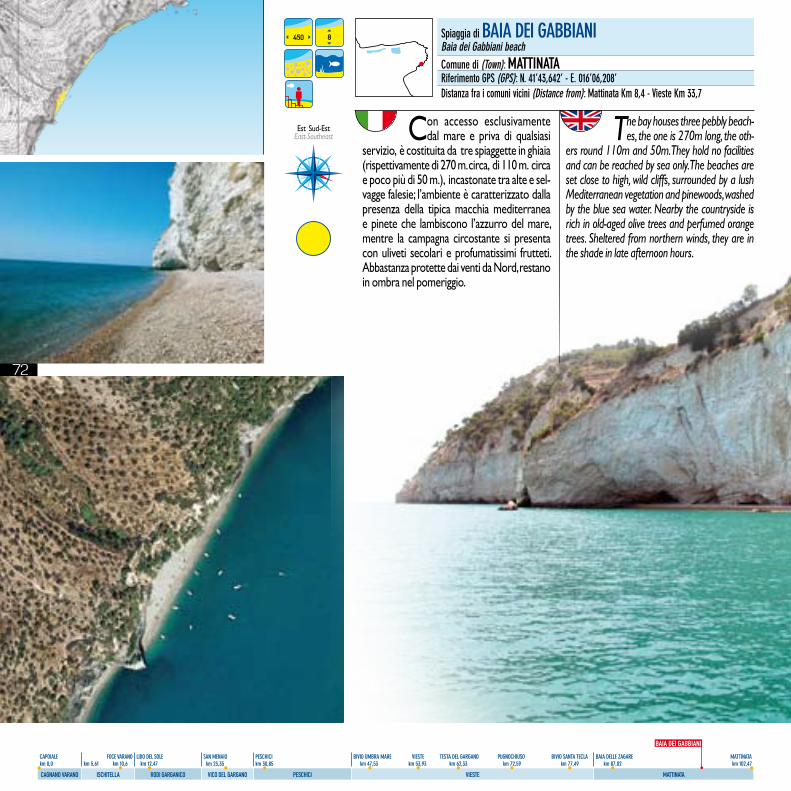
72
CAPOIALE FOCE VARANO LIDO DEL SOLE SAN MENAIO PESCHICI BIVIO UMBRA MARE VIESTE TESTA DEL GARGANO PUGNOCHIUSO BIVIO SANTA TECLA BAIA DELLE ZAGARE MATTINATA km 0,0 km 5,61 km 10,6 km 12,47 km 23,35 km 30,85 km 47,53 km 53,93 km 62,33 km 72,59 km 77,49 km 87,02 km 102,47
CAGNANO VARANO ISCHITELLA RODI GARGANICO VICO DEL GARGANO PESCHICI VIESTE MATTINATA
450 8 Spiaggia di BAIA DEI GABBIANIBaia dei Gabbiani beachComune di (Town): MATTINATARiferimento GPS (GPS): N. 41’43,642’ - E. 016’06,208’Distanza fra i comuni vicini (Distance from): Mattinata Km 8,4 - Vieste Km 33,7
BAIA DEI GABBIANI
Est Sud-Est East-Southeast Con accesso esclusivamente
dal mare e priva di qualsiasi servizio, è costituita da tre spiaggette in ghiaia (rispettivamente di 270 m. circa, di 110 m. circa e poco più di 50 m.), incastonate tra alte e sel-vagge falesie; l’ambiente è caratterizzato dalla presenza della tipica macchia mediterranea e pinete che lambiscono l’azzurro del mare, mentre la campagna circostante si presenta con uliveti secolari e profumatissimi frutteti. Abbastanza protette dai venti da Nord, restano in ombra nel pomeriggio.
The bay houses three pebbly beach-es, the one is 270m long, the oth-
ers round 110m and 50m. They hold no facilities and can be reached by sea only. The beaches are set close to high, wild cliffs, surrounded by a lush Mediterranean vegetation and pinewoods, washed by the blue sea water. Nearby the countryside is rich in old-aged olive trees and perfumed orange trees. Sheltered from northern winds, they are in the shade in late afternoon hours.
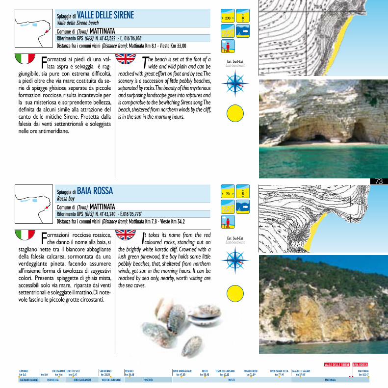
73
CAPOIALE FOCE VARANO LIDO DEL SOLE SAN MENAIO PESCHICI BIVIO UMBRA MARE VIESTE TESTA DEL GARGANO PUGNOCHIUSO BIVIO SANTA TECLA BAIA DELLE ZAGARE MATTINATA km 0,0 km 5,61 km 10,6 km 12,47 km 23,35 km 30,85 km 47,53 km 53,93 km 62,33 km 72,59 km 77,49 km 87,02 km 102,47
CAGNANO VARANO ISCHITELLA RODI GARGANICO VICO DEL GARGANO PESCHICI VIESTE MATTINATA
Formazioni rocciose rossicce, che danno il nome alla baia, si
stagliano nette tra il biancore abbagliante della falesia calcarea, sormontata da una verdeggiante pineta, facendo assumere all’insieme forma di tavolozza di suggestivi colori. Presenta spiaggette di ghiaia mista, accessibili solo via mare, riparate dai venti settentrionali e soleggiate il mattino. Di note-vole fascino le piccole grotte circostanti.
It takes its name from the red coloured rocks, standing out on
the brightly white karstic cliff. Crowned with a lush green pinewood, the bay holds some little pebbly beaches, that, sheltered from northern winds, get sun in the morning hours. It can be reached by sea only, nearby, worth visiting are the sea caves.
230
70
8
5
Spiaggia di VALLE DELLE SIRENEValle delle Sirene beachComune di (Town): MATTINATARiferimento GPS (GPS): N. 41’43,522’ - E. 016’06,106’Distanza fra i comuni vicini (Distance from): Mattinata Km 8,1 - Vieste Km 33,00
Spiaggia di BAIA ROSSARossa bayComune di (Town): MATTINATARiferimento GPS (GPS): N. 41’43,240’ - E.016’05,778’Distanza fra i comuni vicini (Distance from): Mattinata Km 7,8 - Vieste Km 34,2
VALLE DELLE SIRENE BAIA ROSSA
Est Sud-Est East-Southeast
Est Sud-Est East-Southeast
Formatasi ai piedi di una val-lata aspra e selvaggia è rag-
giungibile, sia pure con estrema difficoltà, a piedi oltre che via mare; costituita da se-rie di spiagge ghiaiose separate da piccole formazioni rocciose, risulta incantevole per la sua misteriosa e sorprendente bellezza, definita da alcuni simile alla attrazione del canto delle mitiche Sirene. Protetta dalla falesia dai venti settentrionali e soleggiata nelle ore antimeridiane.
The beach is set at the foot of a wide and wild plain and can be
reached with great effort on foot and by sea. The scenery is a succession of little pebbly beaches, separated by rocks. The beauty of this mysterious and surprising landscape goes into raptures and is comparable to the bewitching Sirens song. The beach, sheltered from northern winds by the cliff, is in the sun in the morning hours.
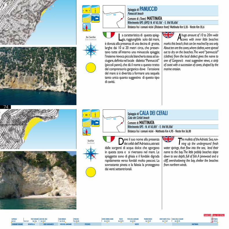
74
CAPOIALE FOCE VARANO LIDO DEL SOLE SAN MENAIO PESCHICI BIVIO UMBRA MARE VIESTE TESTA DEL GARGANO PUGNOCHIUSO BIVIO SANTA TECLA BAIA DELLE ZAGARE MATTINATA km 0,0 km 5,61 km 10,6 km 12,47 km 23,35 km 30,85 km 47,53 km 53,93 km 62,33 km 72,59 km 77,49 km 87,02 km 102,47
CAGNANO VARANO ISCHITELLA RODI GARGANICO VICO DEL GARGANO PESCHICI VIESTE MATTINATA
La caratteristica di questa spiag-gia, raggiungibile solo dal mare,
è dovuta alla presenza di una decina di grotte, larghe dai 10 ai 20 metri circa, che presen-tano tutte all’interno una minuscola spiaggia; l’insieme rievoca piccola biancheria stesa ad as-ciugare, definita nel locale dialetto “Pannuccid” (piccoli panni), che dà il nome a questo tratto del comprensorio garganico dove l’erosione del mare si è divertita a formare una sequela tanto unica quanto suggestiva di questo tipo di cavità.
A huge amount of 10 to 20m wide caves with inner little beaches
marks this beach, that can be reached by sea only. About ten are the caves, where clothes, were spread out to dry on the beaches. The word “pannuccid” (clothes) from the local dialect gives the name to one of Gargano’s most suggestive views, a strip of coast with a succession of caves, shaped by the marine erosion.
Deve il suo nome alla presenza dei cefali dell’Adriatico, attratti
dalle sorgenti di acqua dolce che sgorgano in questa zona e si riversano nel mare. Le spiaggette sono di ghiaia e il fondale digrada rapidamente verso fondali molto pescosi. La sovrastante pineta e la falesia la proteggono dai venti settentrionali.
The mullets of the Adriatic Sea, run-ning up the underground fresh
water springs, that flow into the sea, lend their name to the bay. The little pebbly beaches slope down to sea depth, full of fish. A pinewood and a cliff, overshadowing the bay, shelter the beaches from northern winds.
70
80
4
5
Spiaggia di PANUCCIDPanuccid beachComune di (Town): MATTINATARiferimento GPS (GPS): N. 41’43,136’ - E. 016’05,656’Distanza fra i comuni vicini (Distance from): Mattinata Km 5,35 - Vieste Km 35,6
Spiaggia di CALA DEI CEfALICala dei Cefali beachComune di MATTINATARiferimento GPS - N. 41’43,051’ - E. 016’05,556’Distanza fra i comuni vicini - Mattinata Km 4,95 - Vieste Km 36,00
Sud-EstSoutheast
PANUCCID CALA DEI CEFALI
Est Sud-Est East-Southeast
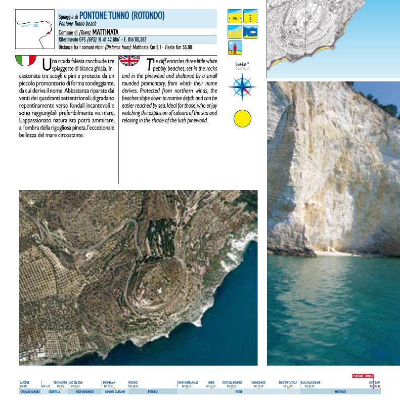
75
CAPOIALE FOCE VARANO LIDO DEL SOLE SAN MENAIO PESCHICI BIVIO UMBRA MARE VIESTE TESTA DEL GARGANO PUGNOCHIUSO BIVIO SANTA TECLA BAIA DELLE ZAGARE MATTINATA km 0,0 km 5,61 km 10,6 km 12,47 km 23,35 km 30,85 km 47,53 km 53,93 km 62,33 km 72,59 km 77,49 km 87,02 km 102,47
CAGNANO VARANO ISCHITELLA RODI GARGANICO VICO DEL GARGANO PESCHICI VIESTE MATTINATA
Una ripida falesia racchiude tre spiaggette di bianca ghiaia, in-
castonate tra scogli e pini e protette da un piccolo promontorio di forma tondeggiante, da cui deriva il nome. Abbastanza riparate dai venti dei quadranti settentrionali, digradano repentinamente verso fondali incantevoli e sono raggiungibili preferibilmente via mare. L’appassionato naturalista potrà ammirare, all’ombra della rigogliosa pineta, l’eccezionale bellezza del mare circostante.
The cliff encircles three little white pebbly beaches, set in the rocks
and in the pinewood and sheltered by a small rounded promontory, from which their name derives. Protected from northern winds, the beaches slope down to marine depth and can be easier reached by sea. Ideal for those, who enjoy watching the explosion of colours of the sea and relaxing in the shade of the lush pinewood.
90 6Spiaggia di PONTONE TUNNO (ROTONDO)Pontone Tunno beachComune di (Town): MATTINATARiferimento GPS (GPS): N. 41’42,886’ - E. 016’05,383’Distanza fra i comuni vicini (Distance from): Mattinata Km 8,1 - Vieste Km 33,00
Sud-Est MSoutheast
PONTONE TUNNO
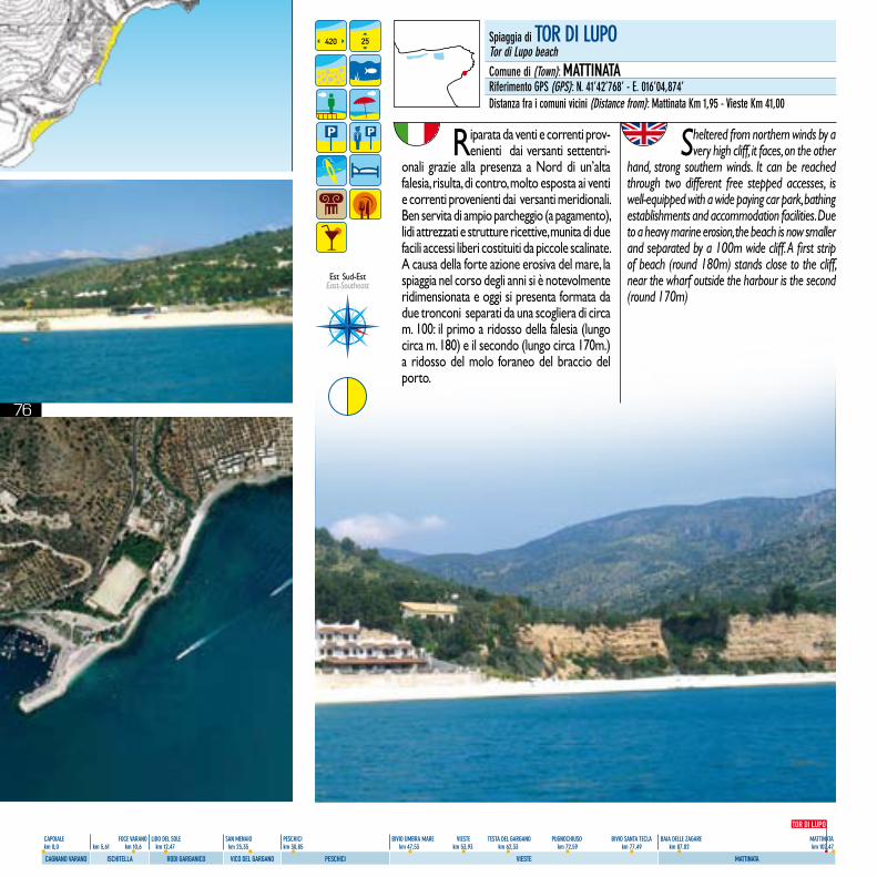
76
CAPOIALE FOCE VARANO LIDO DEL SOLE SAN MENAIO PESCHICI BIVIO UMBRA MARE VIESTE TESTA DEL GARGANO PUGNOCHIUSO BIVIO SANTA TECLA BAIA DELLE ZAGARE MATTINATA km 0,0 km 5,61 km 10,6 km 12,47 km 23,35 km 30,85 km 47,53 km 53,93 km 62,33 km 72,59 km 77,49 km 87,02 km 102,47
CAGNANO VARANO ISCHITELLA RODI GARGANICO VICO DEL GARGANO PESCHICI VIESTE MATTINATA
Riparata da venti e correnti prov-enienti dai versanti settentri-
onali grazie alla presenza a Nord di un’alta falesia, risulta, di contro, molto esposta ai venti e correnti provenienti dai versanti meridionali. Ben servita di ampio parcheggio (a pagamento), lidi attrezzati e strutture ricettive, munita di due facili accessi liberi costituiti da piccole scalinate. A causa della forte azione erosiva del mare, la spiaggia nel corso degli anni si è notevolmente ridimensionata e oggi si presenta formata da due tronconi separati da una scogliera di circa m. 100: il primo a ridosso della falesia (lungo circa m. 180) e il secondo (lungo circa 170m.) a ridosso del molo foraneo del braccio del porto.
Sheltered from northern winds by a very high cliff, it faces, on the other
hand, strong southern winds. It can be reached through two different free stepped accesses, is well-equipped with a wide paying car park, bathing establishments and accommodation facilities. Due to a heavy marine erosion, the beach is now smaller and separated by a 100m wide cliff. A first strip of beach (round 180m) stands close to the cliff, near the wharf outside the harbour is the second (round 170m)
420 25 Spiaggia di TOR DI LUPOTor di Lupo beachComune di (Town): MATTINATARiferimento GPS (GPS): N. 41’42’768’ - E. 016’04,874’Distanza fra i comuni vicini (Distance from): Mattinata Km 1,95 - Vieste Km 41,00
TOR DI LUPO
Est Sud-Est East-Southeast
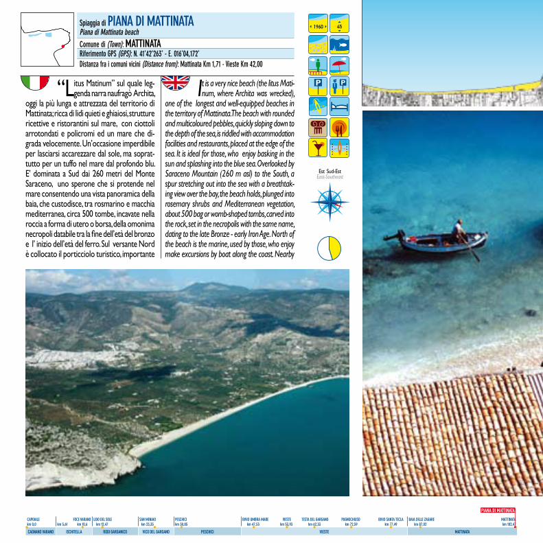
77
CAPOIALE FOCE VARANO LIDO DEL SOLE SAN MENAIO PESCHICI BIVIO UMBRA MARE VIESTE TESTA DEL GARGANO PUGNOCHIUSO BIVIO SANTA TECLA BAIA DELLE ZAGARE MATTINATA km 0,0 km 5,61 km 10,6 km 12,47 km 23,35 km 30,85 km 47,53 km 53,93 km 62,33 km 72,59 km 77,49 km 87,02 km 102,47
CAGNANO VARANO ISCHITELLA RODI GARGANICO VICO DEL GARGANO PESCHICI VIESTE MATTINATA
“Litus Matinum” sul quale leg-genda narra naufragò Archita,
oggi la più lunga e attrezzata del territorio di Mattinata; ricca di lidi quieti e ghiaiosi, strutture ricettive e ristorantini sul mare, con ciottoli arrotondati e policromi ed un mare che di-grada velocemente. Un’occasione imperdibile per lasciarsi accarezzare dal sole, ma soprat-tutto per un tuffo nel mare dal profondo blu. E’ dominata a Sud dai 260 metri del Monte Saraceno, uno sperone che si protende nel mare consentendo una vista panoramica della baia, che custodisce, tra rosmarino e macchia mediterranea, circa 500 tombe, incavate nella roccia a forma di utero o borsa, della omonima necropoli databile tra la fine dell’età del bronzo e l’ inizio dell’età del ferro. Sul versante Nord è collocato il porticciolo turistico, importante
It is a very nice beach (the litus Mati-num, where Archita was wrecked),
one of the longest and well-equipped beaches in the territory of Mattinata. The beach with rounded and multicoloured pebbles, quickly sloping down to the depth of the sea, is riddled with accommodation facilities and restaurants, placed at the edge of the sea. It is ideal for those, who enjoy basking in the sun and splashing into the blue sea. Overlooked by Saraceno Mountain (260 m asl) to the South, a spur stretching out into the sea with a breathtak-ing view over the bay, the beach holds, plunged into rosemary shrubs and Mediterranean vegetation, about 500 bag or womb-shaped tombs, carved into the rock, set in the necropolis with the same name, dating to the late Bronze - early Iron Age. North of the beach is the marine, used by those, who enjoy make excursions by boat along the coast. Nearby
Spiaggia di PIANA DI MATTINATAPiana di Mattinata beachComune di (Town): MATTINATARiferimento GPS (GPS): N. 41’42’263’ - E. 016’04,172’Distanza fra i comuni vicini (Distance from): Mattinata Km 1,71 - Vieste Km 42,00
1960 45
PIANA DI MATTINATA
Est Sud-Est East-Southeast
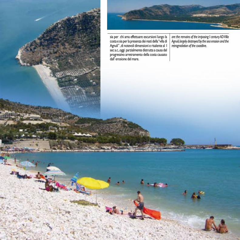
78
CAPOIALE FOCE VARANO LIDO DEL SOLE SAN MENAIO PESCHICI BIVIO UMBRA MARE VIESTE TESTA DEL GARGANO PUGNOCHIUSO BIVIO SANTA TECLA BAIA DELLE ZAGARE MATTINATA km 0,0 km 5,61 km 10,6 km 12,47 km 23,35 km 30,85 km 47,53 km 53,93 km 62,33 km 72,59 km 77,49 km 87,02 km 102,47
CAGNANO VARANO ISCHITELLA RODI GARGANICO VICO DEL GARGANO PESCHICI VIESTE MATTINATA
sia per chi ama effettuare escursioni lungo la costa e sia per la presenza dei resti della “villa di Agnuli” , di notevoli dimensioni e risalente al I sec a.c., oggi parzialmente distrutta a causa del progressivo arretramento della costa causato dall’ erosione del mare.
are the remains of the imposing I century AD Villa Agnuli, largely destroyed by the sea erosion and the retrogradation of the coastline.
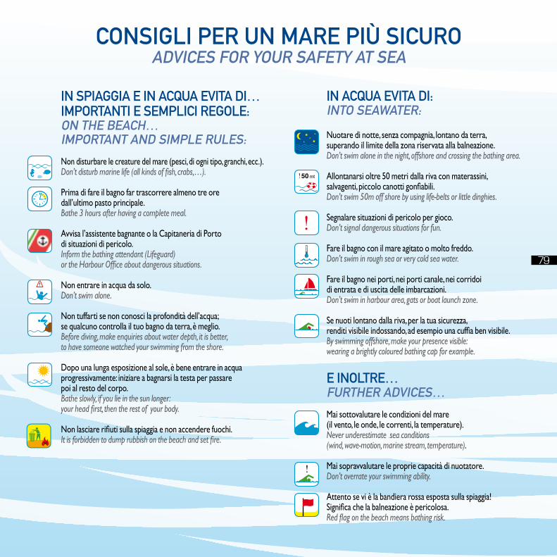
Consigli per un mare più siCuroadviCes for your safety at sea
in spiaggia e in aCQua evita di…importanti e sempliCi regole:on the beaCh…important and simple rules:
Non disturbare le creature del mare (pesci, di ogni tipo, granchi, ecc.).Don’t disturb marine life (all kinds of fish, crabs,…).
Prima di fare il bagno far trascorrere almeno tre oredall’ultimo pasto principale.Bathe 3 hours after having a complete meal.
Avvisa l’assistente bagnante o la Capitaneria di Portodi situazioni di pericolo.Inform the bathing attendant (Lifeguard)or the Harbour Office about dangerous situations.
Non entrare in acqua da solo.Don’t swim alone.
Non tuffarti se non conosci la profondità dell’acqua;se qualcuno controlla il tuo bagno da terra, è meglio.Before diving, make enquiries about water depth, it is better,to have someone watched your swimming from the shore.
Dopo una lunga esposizione al sole, è bene entrare in acquaprogressivamente: iniziare a bagnarsi la testa per passarepoi al resto del corpo.Bathe slowly, if you lie in the sun longer:your head first, then the rest of your body.
Non lasciare rifiuti sulla spiaggia e non accendere fuochi.It is forbidden to dump rubbish on the beach and set fire.
in aCQua evita di:into seawater:
Nuotare di notte, senza compagnia, lontano da terra,superando il limite della zona riservata alla balneazione.Don’t swim alone in the night, offshore and crossing the bathing area.
Allontanarsi oltre 50 metri dalla riva con materassini,salvagenti, piccolo canotti gonfiabili.Don’t swim 50m off shore by using life-belts or little dinghies.
Segnalare situazioni di pericolo per gioco.Don’t signal dangerous situations for fun.
Fare il bagno con il mare agitato o molto freddo.Don’t swim in rough sea or very cold sea water.
Fare il bagno nei porti, nei porti canale, nei corridoidi entrata e di uscita delle imbarcazioni.Don’t swim in harbour area, gats or boat launch zone.
Se nuoti lontano dalla riva, per la tua sicurezza,renditi visibile indossando, ad esempio una cuffia ben visibile.By swimming offshore, make your presence visible:wearing a brightly coloured bathing cap for example.
e inoltre…further adviCes…
Mai sottovalutare le condizioni del mare(il vento, le onde, le correnti, la temperature).Never underestimate sea conditions(wind, wave-motion, marine stream, temperature).
Mai sopravvalutare le proprie capacità di nuotatore.Don’t overrate your swimming ability.
Attento se vi è la bandiera rossa esposta sulla spiaggia!Significa che la balneazione è pericolosa.Red flag on the beach means bathing risk.
79
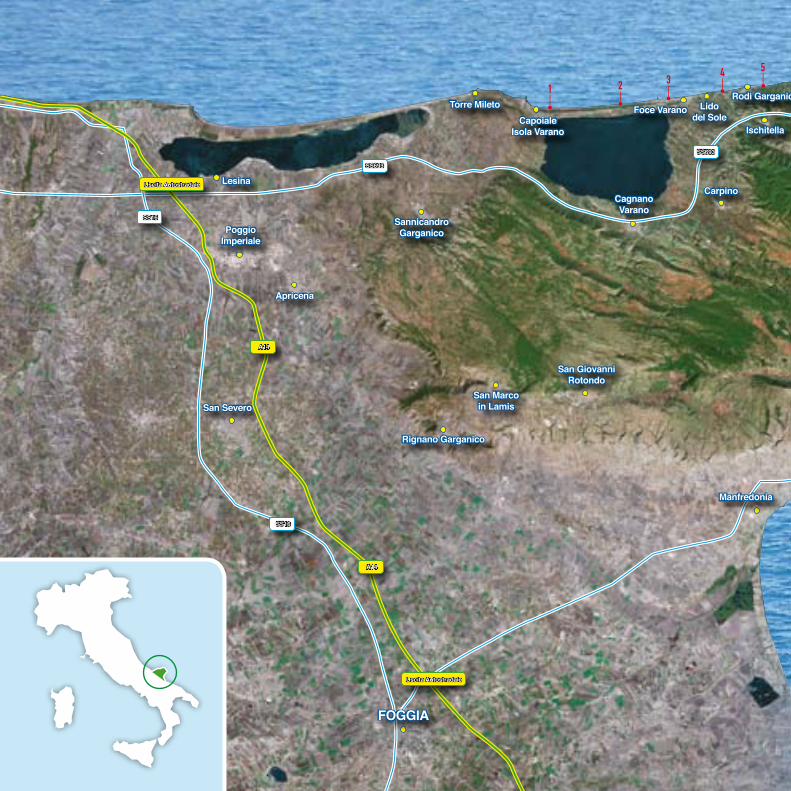
80
CAPOIALE FOCE VARANO LIDO DEL SOLE SAN MENAIO PESCHICI BIVIO UMBRA MARE VIESTE TESTA DEL GARGANO PUGNOCHIUSO BIVIO SANTA TECLA BAIA DELLE ZAGARE MATTINATA km 0,0 km 5,61 km 10,6 km 12,47 km 23,35 km 30,85 km 47,53 km 53,93 km 62,33 km 72,59 km 77,49 km 87,02 km 102,47
CAGNANO VARANO ISCHITELLA RODI GARGANICO VICO DEL GARGANO PESCHICI VIESTE MATTINATA
1 2 34 5
6 78
9
1011
1213 14
15 1716 18
2324
1920
2122 25
26
2728
29
3031
32 33
34
353637
38
3940
41
4243
44
4546
4748
4950
5152
53
54
55
56
57
58
59
6061
62
63
64
65
PoggioImperiale
Apricena
CagnanoVarano
Foce VaranoCapoiale
Isola Varano
SannicandroGarganico
San Marcoin Lamis
Rignano Garganico
Torre Mileto
Lesina
Lidodel Sole
Rodi Garganico
Ischitella
Carpino
San GiovanniRotondo
San Severo
Vico delGargano
San Menaio
Manfredonia
FoGGIA
A14
A14
Uscita Autostradale
Uscita Autostradale
SS16
SS16
SS693
SS693
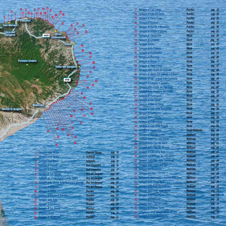
81
17 Spiaggia di Cala Lunga Peschici pag. 3318 Spiaggia di Cala del Turco Peschici pag. 3419 Spiaggia di Santa Croce Peschici pag. 3420 Spiaggia di Gusmay Peschici pag. 3521 Spiaggia di Bescile o Manacora Peschici pag. 3622 Spiaggia di Sfinale o Spinare Peschici pag. 3723 Spiaggia di Sfinalicchio Vieste pag. 4024 Spiaggia di Crovatico Vieste pag. 4125 Spiaggia Stretta Vieste pag. 4226 Spiaggia della Chianca Vieste pag. 4327 Spiaggia di Scialmarino Vieste pag. 4428 Spiaggia di Molinella Vieste pag. 46 29 Spiaggia di Braico Vieste pag. 4730 Spiaggia di Punta Lunga Vieste pag. 4731 Spiaggia della Grotta dei Colombi Vieste pag. 4832 Spiaggia di dietro San Lorenzo o U murt Vieste pag. 4833 Spiaggia di San Lorenzo o del Convento Vieste pag. 4934 Spiaggia di Castello o Scialara Vieste pag. 5035 Spiaggia della Grotta dei Pipistrelli Vieste pag. 5236 Spiaggia della Scogliera dei Cavoli Vieste pag. 5237 Spiaggia di Portonuovo Vieste pag. 5338 Spiaggia di San felice Vieste pag. 5439 Spiaggia di Baia di Campi Vieste pag. 5540 Spiaggia di Cala della Sanguinara Vieste pag. 5641 Spiaggia di Portogreco Vieste pag. 5742 Spiaggia di Portopiatto Vieste pag. 5843 Spiaggia di Pugnochiuso Vieste pag. 5944 Spiaggia di Cala della Pergola Vieste pag. 5945 Spiaggia di Vignanotica Vieste/Mattinata pag. 6046 Spiaggia di Baia del Leone Mattinata pag. 6447 Spiaggia della Cala dell’Aquila Mattinata pag. 6448 Spiaggia della Cala dei Morti Mattinata pag. 6549 Spiaggia della Baia dei Mergoli Mattinata pag. 6650 Spiaggia di Cala della Pipa Mattinata pag. 6751 Spiaggia del Grottone del Pescatore Mattinata pag. 6752 Spiaggia della Cala della Cattedrale Mattinata pag. 6853 Spiaggia della Punta dell’Ago Mattinata pag. 6854 Spiaggia del Pescecane Mattinata pag. 6955 Spiaggia del fico Mattinata pag. 6956 Spiaggia di Mattinatella o fontana delle Rose Mattinata pag. 7057 Spiaggia delle Pietre Nere Mattinata pag. 7058 Spiaggia della Baia dei Gabbiani Mattinata pag. 7259 Spiaggia della Valle delle Sirene Mattinata pag. 7360 Spiaggia della Baia Rossa Mattinata pag. 7361 Spiaggia dei Panuccid Mattinata pag. 7462 Spiaggia della Cala dei Cefali Mattinata pag. 7463 Spiaggia di Pontone Tunno Mattinata pag. 7564 Complesso delle spiagge di Tor di Lupo Mattinata pag. 7665 Spiaggia di Piana di Mattinata Mattinata pag. 77
1 2 34 5
6 78
9
1011
1213 14
15 1716 18
2324
1920
2122 25
26
2728
29
3031
32 33
34
353637
38
3940
41
4243
44
4546
4748
4950
5152
53
54
55
56
57
58
59
6061
62
63
64
65
Rodi Garganico
Ischitella
Monte S. Angelo
Foresta Umbra
Vico delGargano
San MenaioPeschici
BivioUmbramare
Vieste
Mattinata
SP53
SS89
Testa del Gargano
1 Spiaggia Isola Varano Cagnano Varano pag. 102 Spiaggia Isola Varano Ischitella pag. 123 Spiaggia foce Varano Ischitella pag. 134 Spiaggia di Ponente Rodi Garganico pag. 165 Spiaggia di Levante Rodi Garganico pag. 176 Spiaggia di San Menaio Vico del Gargano pag. 207 Spiaggia dei Cento Scalini o delle Tufare Vico del Gargano pag. 228 Spiaggia dello scoglio della Madonna o Sospetto Vico del Gargano pag. 239 Spiaggia di Calenelle Vico del Gargano pag. 24
10 Spiaggia di Jalillo Peschici pag. 2611 Spiaggia di Marina di Peschici Peschici pag. 2712 Spiaggia della Cala Peschici pag. 2913 Spiaggia di Procinisco Peschici pag. 2914 Spiaggia di San Nicola Peschici pag. 3015 Spiaggia Zaiana Peschici pag. 3116 Spiaggia di Manaccora Peschici pag. 32
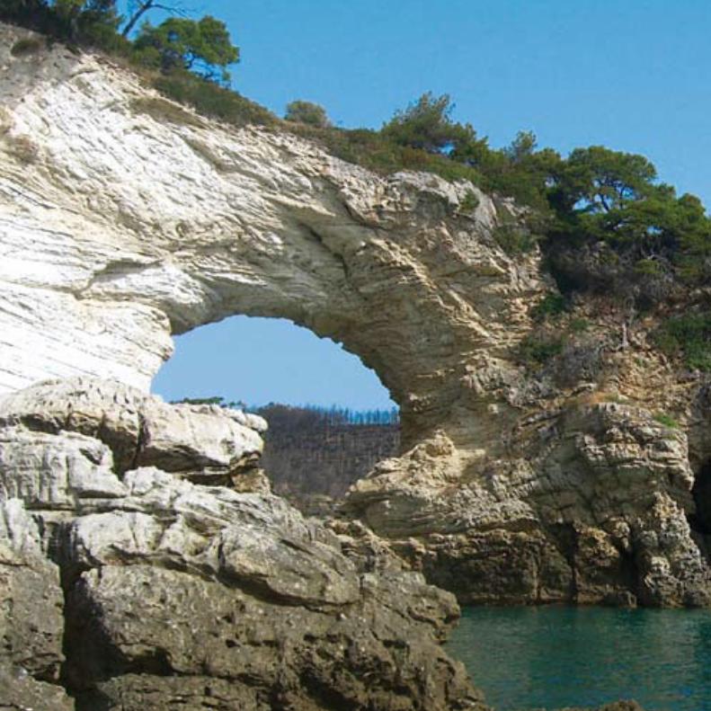
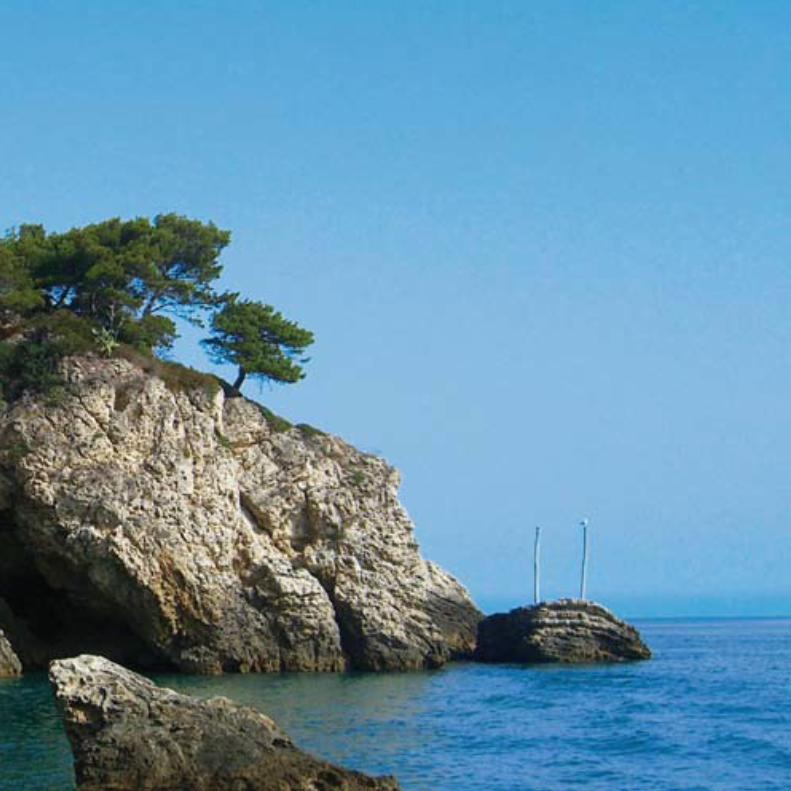
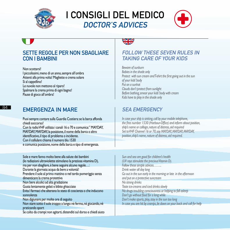
84
CAPOIALE FOCE VARANO LIDO DEL SOLE SAN MENAIO PESCHICI BIVIO UMBRA MARE VIESTE TESTA DEL GARGANO PUGNOCHIUSO BIVIO SANTA TECLA BAIA DELLE ZAGARE MATTINATA km 0,0 km 5,61 km 10,6 km 12,47 km 23,35 km 30,85 km 47,53 km 53,93 km 62,33 km 72,59 km 77,49 km 87,02 km 102,47
CAGNANO VARANO ISCHITELLA RODI GARGANICO VICO DEL GARGANO PESCHICI VIESTE MATTINATA
84
Sole e mare fanno molto bene alla salute dei bambini(le radiazioni ultraviolette stimolano la preziosa vitamina D),ma per non sbagliare, è bene seguire alcune regole…:Durante la giornata: acqua da bere a volontà!Prendere il sole al primo mattino o nel tardo pomeriggio senza dimenticare la crema protettivaNon bere alcolici ad alta gradazioneGusta lentamente gelati e bibite ghiacciateEvita I farmaci che alterano lo stato di coscienza o che inducono sonnolenzaNon digiunare per molte ore di seguitoNon stare sotto il sole troppo a lungo: nè fermo, nè giocando, nè praticando sportSe colto da crampi: non agitarti, distenditi sul dorso e chiedi aiuto
Sun and sea are good for children’s health(UV rays stimulate the precious Vitamin D).Follow these simple advices…….. Drink water all day long Go out in the sun early in the morning or late in the afternoonand put on a protective suncreamNo strong drinksTaste ice-creams and iced drinks slowlyNo drugs troubling consciousness or helping to fall asleepDon’t go without food for a long whileDon’t make sports, play, stay in the sun too longIn case you are hit by cramps, lie down on your back and call for help
i Consigli del mediCodoCtor’s adviCes
sette regole per non sbagliareCon i bambini
Non scottarsi!I piccolissimi, meno di un anno, sempre all’ombra Attenti alla prima volta! Magliette e crema solareSi al cappellino!Le nuvole non mettono al riparo!Spalmare la crema prima di ogni bagno!Pause di gioco all’ombra!
follow these seven rules intaking Care of your kids
Beware of sunburnBabies in the shade onlyProtect with sun cream and T-shirt the first going out in the sunof your kids’ bodyPut on a sunhatClouds don’t protect from sunlightBefore bathing, smear your kids’ body with creamKids have to play in the shade only
emergenZa in mare
Puoi sempre contare sulla Guardia Costiera: se la barca affonda chiedi soccorso! Con la radio VHF utilizza i canali 16 o 70 e comunica:” MAYDAY, MAYDAY, MAYDAY, la posizione, il nome della barca o altro identificativo, il tipo di problema o incidente.Con il cellulare chiama il numero blu 1530e comunica posizione, nome della barca e tipo di emergenza.
sea emergenCy
In case your ship is sinking, call by your mobile telephone,the free number 1530 (Harbour-Office) and inform about position,ship’s name or callsign, nature of distress, aid requiredSet to VHF Channel 16 or 70, say MAYDAY, MAYDAY, MAYDAY,position, ship’s name, nature of distress, aid required.


